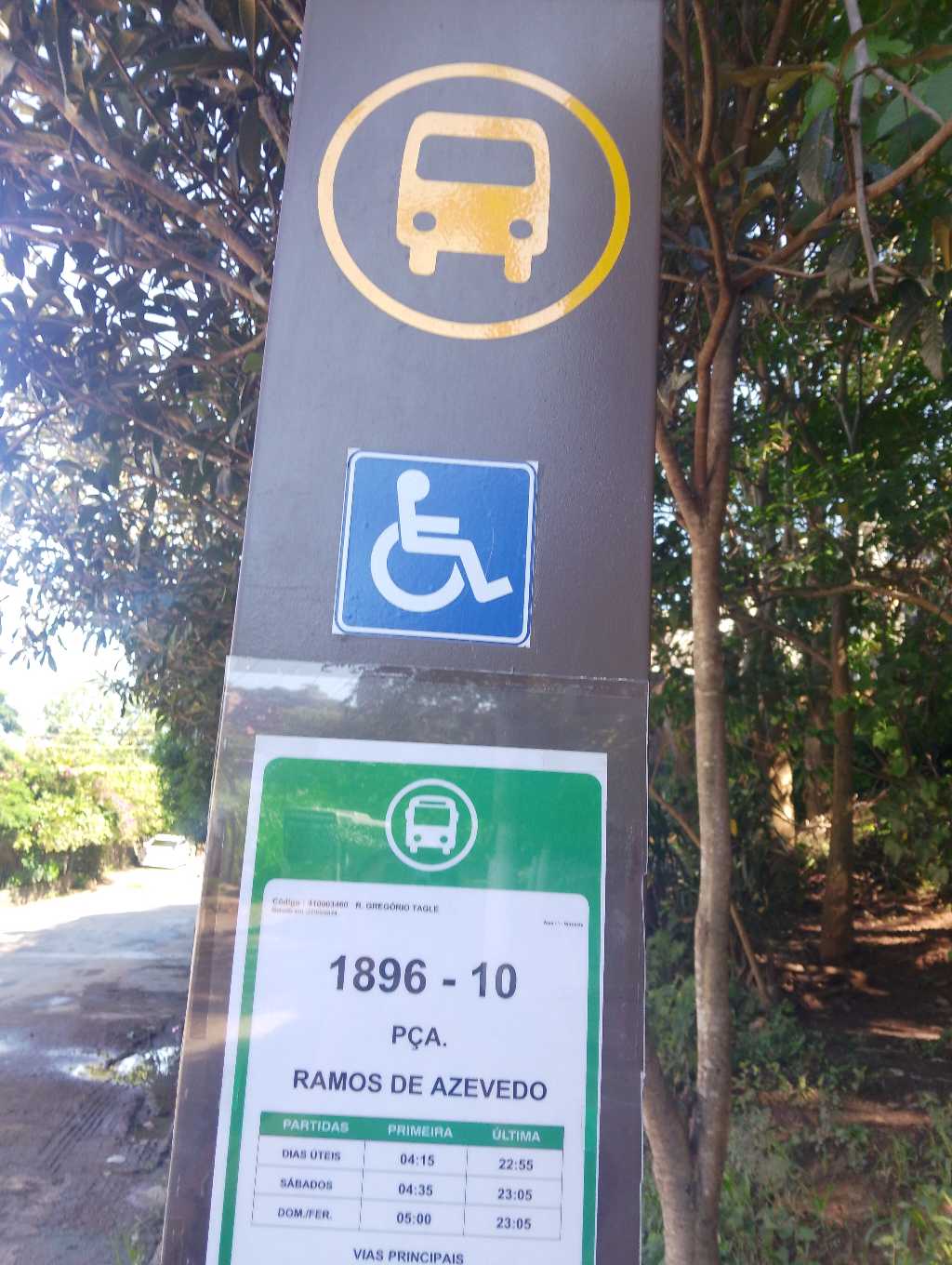
R. Gregório Tagle stop - Friday schedule
| Line | Direction | Time |
|---|---|---|
| 1896-10 | Pça. Ramos de Azevedo | 4:15 AM |
| 1896-10 | Pça. Ramos de Azevedo | 4:35 AM |
| 1896-10 | Pça. Ramos de Azevedo | 4:54 AM |
| 1896-10 | Pça. Ramos de Azevedo | 5:12 AM |
| 1896-10 | Pça. Ramos de Azevedo | 5:30 AM |
| 1896-10 | Pça. Ramos de Azevedo | 5:45 AM |
| 1896-10 | Pça. Ramos de Azevedo | 6:00 AM |
| 1896-10 | Pça. Ramos de Azevedo | 6:15 AM |
| 1896-10 | Pça. Ramos de Azevedo | 6:35 AM |
| 1896-10 | Pça. Ramos de Azevedo | 6:55 AM |
| 1896-10 | Jaraguá | 6:58 AM |
| 1896-10 | Pça. Ramos de Azevedo | 7:15 AM |
| 1896-10 | Jaraguá | 7:30 AM |
| 1896-10 | Pça. Ramos de Azevedo | 7:35 AM |
| 1896-10 | Pça. Ramos de Azevedo | 7:55 AM |
| 1896-10 | Jaraguá | 7:56 AM |
| 1896-10 | Pça. Ramos de Azevedo | 8:20 AM |
| 1896-10 | Jaraguá | 8:22 AM |
| 1896-10 | Jaraguá | 8:48 AM |
| 1896-10 | Pça. Ramos de Azevedo | 8:54 AM |
| 1896-10 | Jaraguá | 9:11 AM |
| 1896-10 | Pça. Ramos de Azevedo | 9:30 AM |
| 1896-10 | Jaraguá | 9:31 AM |
| 1896-10 | Jaraguá | 9:51 AM |
| 1896-10 | Pça. Ramos de Azevedo | 10:08 AM |
Directions to R. Gregório Tagle stop (Jaraguá) with public transit
The following transit lines have routes that pass near R. Gregório Tagle
 Bus: 1896-10, 8009-31.
- Train: LINHA 7.
How to get to R. Gregório Tagle stop by bus?
Click on the bus route to see step by step directions with maps, line arrival times and updated time schedules.
How to get to R. Gregório Tagle stop by train?
Click on the train route to see step by step directions with maps, line arrival times and updated time schedules.
Bus stops near R. Gregório Tagle stop in Jaraguá
- R. Pedro Valdívia, 45, 1 min walk,
- R. Gregório Tagle, 172, 2 min walk,
Train stations near R. Gregório Tagle station in Jaraguá
- Jaraguá, 31 min walk,
Bus lines to R. Gregório Tagle stop in Jaraguá
- 1896-10, Jaraguá,
- 8009-31, Term. Pirituba,
What are the closest stations to R. Gregório Tagle?
The closest stations to R. Gregório Tagle are:
- R. Pedro Valdívia, 45 stop is 7 meters away, 1 min walk.
- R. Gregório Tagle, 172 stop is 155 meters away, 2 min walk.
- Jaraguá station is 2437 meters away, 31 min walk.
Which bus lines stop near R. Gregório Tagle?
These bus lines stop near R. Gregório Tagle: 1896-10, 8009-31.
Which train line stops near R. Gregório Tagle?
LINHA 7 (Jundiaí)
What’s the nearest bus station to R. Gregório Tagle in Jaraguá?
The nearest bus station to R. Gregório Tagle in Jaraguá is R. Pedro Valdívia, 45. It’s a 1 min walk away.
What time is the first train to R. Gregório Tagle in Jaraguá?
The LINHA 7 is the first train that goes to R. Gregório Tagle in Jaraguá. It stops nearby at 4:15 AM.
What time is the last train to R. Gregório Tagle in Jaraguá?
The LINHA 7 is the last train that goes to R. Gregório Tagle in Jaraguá. It stops nearby at 12:47 AM.
What time is the first bus to R. Gregório Tagle in Jaraguá?
The 1896-10 is the first bus that goes to R. Gregório Tagle in Jaraguá. It stops nearby at 4:15 AM.
What time is the last bus to R. Gregório Tagle in Jaraguá?
The 8009-31 is the last bus that goes to R. Gregório Tagle in Jaraguá. It stops nearby at 1:43 AM.
R. Gregório Tagle station
 Taken by Anonymous
See R. Gregório Tagle stop, Jaraguá, on the map
Public transit to R. Gregório Tagle stop in Jaraguá
Looking for directions to R. Gregório Tagle in Jaraguá, Brazil?
Download the Moovit App to find the current schedule and step-by-step directions for Bus or Train routes that pass through R. Gregório Tagle.
Looking for the nearest stops closest to R. Gregório Tagle ? Check out this list of closest stops to your destination: R. Pedro Valdívia; R. Gregório Tagle; Jaraguá.
Bus: 1896-10, 8009-31.Train: LINHA 7.
We make riding on public transit to R. Gregório Tagle easy, which is why over 1.7 billion users, including users in Jaraguá trust Moovit as the best app for public transit.
Use the app to navigate to popular places including to the airport, hospital, stadium, grocery store, mall, coffee shop, school, college, and university.
The first line to this stop is 1896-10, at 4:15 AM, and the last line is 1896-10 at 1:52 AM.
SN Rua Gregorio Tagle, São Paulo, Brazil
This stop serves SPTrans’s lines
- R. Pedro Valdívia, 45,
- R. Gregório Tagle, 172
Bus stops near R. Gregório Tagle stop
- Jaraguá
Train station near R. Gregório Tagle station
- Av. Guilherme Cotching, 980,
- Ana Rosa,
- Av. Inconfidência Mineira, 1225,
- R. Maporé, 637,
- Avenida Celso dos Santos 1225,
- R. Voluntários da Pátria, 3744,
- Hospital Leonor Mendes de Barros,
- Rua Capitão John Cordeiro e Silva 57,
- Avenida Rangel Pestana,
- Chácara Klabin,
- Avenida Presidente Castelo Branco (N. 5000),
- Pinheiros,
- São Joaquim,
- Alto da Boa Vista,
- Av Cruzeiro do Sul 3358,
- Praça Jurema • Metrô Sumaré,
- Parada Oscar Freire B/C,
- Avenida Marginal do Ribeirão,
- Avenida Brigadeiro Faria Lima, 3500,
- Butantã
Popular public transit stations in Jaraguá
Get around Jaraguá by public transit!
Traveling around Jaraguá has never been so easy. See step by step directions as you travel to any attraction, street or major public transit station. View bus and train schedules, arrival times, service alerts and detailed routes on a map, so you know exactly how to get to anywhere in Jaraguá.
When traveling to any destination around Jaraguá use Moovit's Live Directions with Get Off Notifications to know exactly where and how far to walk, how long to wait for your line, and how many stops are left. Moovit will alert you when it's time to get off — no need to constantly re-check whether yours is the next stop.
Wondering how to use public transit in Jaraguá or how to pay for public transit in Jaraguá? Moovit public transit app can help you navigate your way with public transit easily, and at minimum cost. It includes public transit fees, ticket prices, and costs. Looking for a map of Jaraguá public transit lines? Moovit public transit app shows all public transit maps in Jaraguá with all Bus, Train, Metro, Light Rail, Ferry, Gondola, Cable Car and Funicular routes and stops on an interactive map.
Sao Paulo Region has 8 transit type(s), including: Bus, Train, Metro, Light Rail, Ferry, Gondola, Cable Car and Funicular, operated by several transit agencies, including SPTrans, CPTM, ViaMobilidade, Aquático SP, SPTRANS, EMTU, ViaQuatro, Auto Ônibus Moratense, GRU Airport (Aeroporto de Guarulhos), Auto Viação Urubupungá (Cajamar), Viação Cometa, Auto Viação Urubupungá (Osasco), Viação Ultra / Rápido Brasil, Auto Viação Urubupungá (Santana de Parnaíba) and Expresso Luxo