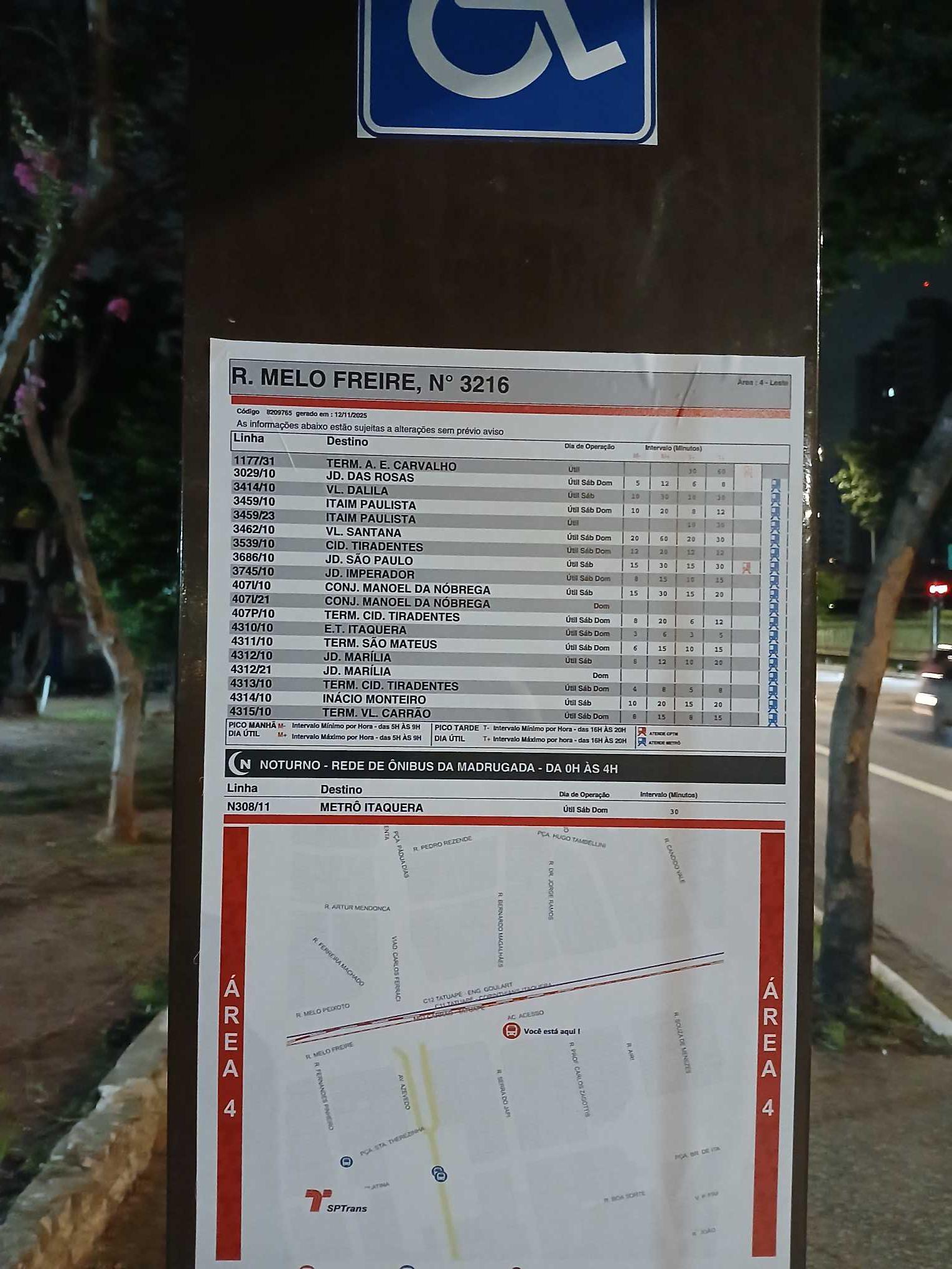
R. Melo Freire, 3216 stop - Monday schedule
| Line | Direction | Time |
|---|---|---|
| N308-11 | Metrô Itaquera | 3:10 AM |
| N308-11 | Metrô Itaquera | 3:40 AM |
| N308-11 | Metrô Itaquera | 4:25 AM |
| 4313-10 | Term. Cid. Tiradentes | 4:49 AM |
| 3462-10 | Vl. Santana | 4:52 AM |
| 4310-10 | E.T. Itaquera | 4:54 AM |
| 4315-10 | Term. Vl. Carrão | 4:55 AM |
| 407P-10 | Term. Cid. Tiradentes | 5:02 AM |
| 4313-10 | Term. Cid. Tiradentes | 5:04 AM |
| 4314-10 | Inácio Monteiro | 5:06 AM |
| 4310-10 | E.T. Itaquera | 5:08 AM |
| 4310-10 | E.T. Itaquera | 5:15 AM |
| 3459-10 | Itaim Paulista | 5:16 AM |
| 4310-10 | E.T. Itaquera | 5:21 AM |
| 4311-10 | Term. São Mateus | 5:21 AM |
| 3539-10 | Cid. Tiradentes | 5:21 AM |
| 3029-10 | Jd. das Rosas | 5:22 AM |
| 3745-10 | Jd. Imperador | 5:22 AM |
| 4312-10 | Jd. Marília | 5:25 AM |
| 4313-10 | Term. Cid. Tiradentes | 5:26 AM |
| 407I-10 | Conj. Manoel da Nóbrega | 5:26 AM |
| 4315-10 | Term. Vl. Carrão | 5:27 AM |
| 407P-10 | Term. Cid. Tiradentes | 5:27 AM |
| 4310-10 | E.T. Itaquera | 5:28 AM |
| 3029-10 | Jd. das Rosas | 5:30 AM |
Directions to R. Melo Freire, 3216 stop (Tatuapé) with public transit
The following transit lines have routes that pass near R. Melo Freire, 3216
 Bus: 3414-10, 3459-10, 3539-10, 4310-10, 4311-10.
- Metro: LINHA 3.
- Train: LINHA 11, LINHA 12.
How to get to R. Melo Freire, 3216 stop by bus?
Click on the bus route to see step by step directions with maps, line arrival times and updated time schedules.
How to get to R. Melo Freire, 3216 stop by train?
Click on the train route to see step by step directions with maps, line arrival times and updated time schedules.
How to get to R. Melo Freire, 3216 stop by metro?
Click on the metro route to see step by step directions with maps, line arrival times and updated time schedules.
Bus stops near R. Melo Freire, 3216 stop in Tatuapé
- R. Tijuco Preto, 671, 1 min walk,
- R. Simas Pimenta, 133, 2 min walk,
- R. Baguari, 64, 3 min walk,
- Rua Coronel Carlos Oliva 36, 5 min walk,
- R. Pe. Estevão Pernet, 832, 6 min walk,
- R. Vilela, 663, 7 min walk,
- Av. Azevedo, 288, 8 min walk,
- Pça. Cel. Sandoval Figueiredo, 9 min walk,
Metro stations near R. Melo Freire, 3216 station in Tatuapé
- Tatuapé, 11 min walk,
Train stations near R. Melo Freire, 3216 station in Tatuapé
- Tatuapé, 11 min walk,
Bus lines to R. Melo Freire, 3216 stop in Tatuapé
- 407J-10, Jardim Soares - Metrô Tatuapé,
- N407-11, Terminal Vila Carrão - Metrô Belém,
- 524L-10, Parque São Lucas - Metrô Tatuapé,
- 3029-10, Jardim Das Rosas - Metrô Tatuapé,
- 3745-10, Jardim Imperador - Metrô Tatuapé,
- 3762-10, Jardim Iva - Metrô Tatuapé,
- 414P-10, Term. Norte Metrô Carrão,
- 2762-10, Ermelino Matarazzo - Metrô Tatuapé,
- 2765-10, Vila Cisper - Metrô Tatuapé,
- 2767-10, Cidade Pedro José Nunes - Metrô Tatuapé,
- 2769-10, Jardim Romano - Metrô Tatuapé,
- 208V-10, Terminal A. E. Carvalho - Terminal Parque Dom Pedro Ii,
- 271P-10, Cangaíba - Pça Do Correio,
- 274P-10, Penha - Metrô Vila Mariana,
- 278A-10, Metrô Santana - Penha,
- N301-11, Terminal A. E. Carvalho - Terminal Parque Dom Pedro Ii,
- 390E-10, Terminal Penha - Terminal Parque Dom Pedro Ii,
- 2290-10, Terminal São Mateus - Terminal Parque Dom Pedro Ii,
- 2363-10, Jardim Domnfer - Terminal Parque Dom Pedro Ii,
- 2551-10, Terminal A. E. Carvalho - Terminal Parque Dom Pedro Ii,
What are the closest stations to R. Melo Freire, 3216?
The closest stations to R. Melo Freire, 3216 are:
- R. Tijuco Preto, 671 stop is 53 meters away, 1 min walk.
- R. Simas Pimenta, 133 stop is 140 meters away, 2 min walk.
- R. Baguari, 64 stop is 216 meters away, 3 min walk.
- Rua Coronel Carlos Oliva 36 stop is 300 meters away, 5 min walk.
- R. Pe. Estevão Pernet, 832 stop is 449 meters away, 6 min walk.
- R. Vilela, 663 stop is 532 meters away, 7 min walk.
- Av. Azevedo, 288 stop is 584 meters away, 8 min walk.
- Pça. Cel. Sandoval Figueiredo stop is 681 meters away, 9 min walk.
- Tatuapé station is 802 meters away, 11 min walk.
Which bus lines stop near R. Melo Freire, 3216?
These bus lines stop near R. Melo Freire, 3216: 3414-10, 3459-10, 3539-10, 4310-10, 4311-10, 4312-10, 4313-10.
Which metro line stops near R. Melo Freire, 3216?
LINHA 3 (Corinthians-Itaquera)
Which train lines stop near R. Melo Freire, 3216?
These train lines stop near R. Melo Freire, 3216: LINHA 11, LINHA 12.
What’s the nearest metro station to R. Melo Freire, 3216 in Tatuapé?
The nearest metro station to R. Melo Freire, 3216 in Tatuapé is Tatuapé. It’s a 11 min walk away.
What’s the nearest train station to R. Melo Freire, 3216 in Tatuapé?
The nearest train station to R. Melo Freire, 3216 in Tatuapé is Tatuapé. It’s a 11 min walk away.
What’s the nearest bus station to R. Melo Freire, 3216 in Tatuapé?
The nearest bus station to R. Melo Freire, 3216 in Tatuapé is R. Tijuco Preto, 671. It’s a 1 min walk away.
What time is the first metro to R. Melo Freire, 3216 in Tatuapé?
The LINHA 3 is the first metro that goes to R. Melo Freire, 3216 in Tatuapé. It stops nearby at 4:58 AM.
What time is the last metro to R. Melo Freire, 3216 in Tatuapé?
The LINHA 3 is the last metro that goes to R. Melo Freire, 3216 in Tatuapé. It stops nearby at 12:32 AM.
What time is the first train to R. Melo Freire, 3216 in Tatuapé?
The LINHA 12 is the first train that goes to R. Melo Freire, 3216 in Tatuapé. It stops nearby at 4:04 AM.
What time is the last train to R. Melo Freire, 3216 in Tatuapé?
The LINHA 11 is the last train that goes to R. Melo Freire, 3216 in Tatuapé. It stops nearby at 12:54 AM.
What time is the first bus to R. Melo Freire, 3216 in Tatuapé?
The N301-11 is the first bus that goes to R. Melo Freire, 3216 in Tatuapé. It stops nearby at 3:08 AM.
What time is the last bus to R. Melo Freire, 3216 in Tatuapé?
The N301-11 is the last bus that goes to R. Melo Freire, 3216 in Tatuapé. It stops nearby at 3:08 AM.
R. Melo Freire, 3216 station
 Taken by Anonymous
See R. Melo Freire, 3216 stop, Tatuapé, on the map
Public transit to R. Melo Freire, 3216 stop in Tatuapé
Looking for directions to R. Melo Freire, 3216 in Tatuapé, Brazil?
Download the Moovit App to find the current schedule and step-by-step directions for Bus, Metro or Train routes that pass through R. Melo Freire, 3216.
Looking for the nearest stops closest to R. Melo Freire, 3216 ? Check out this list of closest stops to your destination: R. Tijuco Preto; R. Simas Pimenta; R. Baguari; Rua Coronel Carlos Oliva 36; R. Pe. Estevão Pernet; R. Vilela; Av. Azevedo; Pça. Cel. Sandoval Figueiredo; Tatuapé.
Bus: 3414-10, 3459-10, 3539-10, 4310-10, 4311-10, 4312-10, 4313-10, 407J-10, N407-11, 524L-10, 3029-10, 3745-10, 414P-10, 2762-10, 2765-10, 2767-10, 2769-10, 208V-10, 271P-10, 274P-10, 278A-10, N301-11.Metro: LINHA 3.Train: LINHA 11, LINHA 12.
We make riding on public transit to R. Melo Freire, 3216 easy, which is why over 1.7 billion users, including users in Tatuapé trust Moovit as the best app for public transit.
Use the app to navigate to popular places including to the airport, hospital, stadium, grocery store, mall, coffee shop, school, college, and university.
The first line to this stop is N308-11, at 3:10 AM, and the last line is N308-11 at 2:40 AM.
This stop serves SPTrans’s lines
- R. Tijuco Preto, 671,
- R. Simas Pimenta, 133,
- R. Baguari, 64,
- Rua Coronel Carlos Oliva 36,
- R. Pe. Estevão Pernet, 832,
- R. Vilela, 663,
- Av. Azevedo, 288,
- Pça. Cel. Sandoval Figueiredo
Bus stops near R. Melo Freire, 3216 stop
- Tatuapé
Metro station near R. Melo Freire, 3216 station
- Tatuapé
Train station near R. Melo Freire, 3216 station
- Av. Indianópolis, 3096,
- Av. Dr. Abraão Ribeiro, 313,
- Avenida Adolfo Pinheiro 1000,
- Terminal Urbano Amador Aguiar (Vila Yara),
- Av. Alexios Jafet,
- Hospital Campo Limpo B/C,
- R. Clodomiro Amazonas, 1291,
- R. João Amado Coutinho, 400,
- Alto da Boa Vista,
- Rua Pedro de Toledo 1082,
- Rua Doutor Miguel de Campos Júnior- 100,
- R. Alcântara, 113,
- Estrada Marechal Tomoki Hiramoto (Sitio Tirulim),
- Av. Horácio Lafer, 225,
- R. Leopoldo Couto de Magalhães Júnior, 758,
- Piratininga,
- Av. Cde. de Frontin, 542,
- Juventus-Mooca,
- Av. Angélica, 928,
- Av. República do Líbano, 990
Popular public transit stations in Tatuapé
Get around Tatuapé by public transit!
Traveling around Tatuapé has never been so easy. See step by step directions as you travel to any attraction, street or major public transit station. View bus and train schedules, arrival times, service alerts and detailed routes on a map, so you know exactly how to get to anywhere in Tatuapé.
When traveling to any destination around Tatuapé use Moovit's Live Directions with Get Off Notifications to know exactly where and how far to walk, how long to wait for your line, and how many stops are left. Moovit will alert you when it's time to get off — no need to constantly re-check whether yours is the next stop.
Wondering how to use public transit in Tatuapé or how to pay for public transit in Tatuapé? Moovit public transit app can help you navigate your way with public transit easily, and at minimum cost. It includes public transit fees, ticket prices, and costs. Looking for a map of Tatuapé public transit lines? Moovit public transit app shows all public transit maps in Tatuapé with all Bus, Train, Metro, Light Rail, Ferry, Gondola, Cable Car and Funicular routes and stops on an interactive map.
Sao Paulo Region has 8 transit type(s), including: Bus, Train, Metro, Light Rail, Ferry, Gondola, Cable Car and Funicular, operated by several transit agencies, including SPTrans, CPTM, ViaMobilidade, Aquático SP, SPTRANS, EMTU, ViaQuatro, Auto Ônibus Moratense, GRU Airport (Aeroporto de Guarulhos), Auto Viação Urubupungá (Cajamar), Viação Cometa, Auto Viação Urubupungá (Osasco), Viação Ultra / Rápido Brasil, Auto Viação Urubupungá (Santana de Parnaíba) and Expresso Luxo