Reti station - Monday schedule
| Line | Direction | Time |
|---|---|---|
| N3S | Ostiense Square-Pyramid (Metro-Rail) | 3:25 AM |
| N3S | Ostiense Square-Pyramid (Metro-Rail) | 3:25 AM |
| N3S | Ostiense Square-Pyramid (Metro-Rail) | 4:00 AM |
| N3S | Ostiense Square-Pyramid (Metro-Rail) | 4:00 AM |
| N3S | Ostiense Square-Pyramid (Metro-Rail) | 4:30 AM |
| N3S | Ostiense Square-Pyramid (Metro-Rail) | 4:30 AM |
| 2 | Mancini | 4:39 AM |
| 2 | Flaminio | 4:48 AM |
| 2 | Mancini | 4:51 AM |
| N3S | Ostiense Square-Pyramid (Metro-Rail) | 5:00 AM |
| N3S | Ostiense Square-Pyramid (Metro-Rail) | 5:00 AM |
| 3 | Valle Giulia | 5:01 AM |
| 2 | Mancini | 5:02 AM |
| 19L | Valle Giulia | 5:17 AM |
| 3 | Valle Giulia | 5:17 AM |
| 19L | Valle Giulia | 5:25 AM |
| 3 | Valle Giulia | 5:33 AM |
| 19L | Valle Giulia | 5:38 AM |
| 3 | Valle Giulia | 5:50 AM |
| 19L | Valle Giulia | 5:51 AM |
| 2 | Mancini | 5:59 AM |
| 19L | Valle Giulia | 6:05 AM |
| 3 | Valle Giulia | 6:07 AM |
| 19L | Valle Giulia | 6:19 AM |
| 3 | Valle Giulia | 6:24 AM |
Directions to Reti station (Roma) with public transit
The following transit lines have routes that pass near Reti
 Bus: 163, 492, 542, 71, C2.
- Train: FL5, R.
- Metro: A.
- Light Rail: 3.
How to get to Reti station by bus?
Click on the bus route to see step by step directions with maps, line arrival times and updated time schedules.
How to get to Reti station by train?
Click on the train route to see step by step directions with maps, line arrival times and updated time schedules.
How to get to Reti station by metro?
Click on the metro route to see step by step directions with maps, line arrival times and updated time schedules.
Bus stops near Reti stop in Roma
- Sardi, 2 min walk,
- Tiburtina/Marrucini, 3 min walk,
- Verano, 5 min walk,
- Roma | De Lollis Street, 7 min walk,
Light Rail stations near Reti station in Roma
- Verano/De Lollis, 5 min walk,
Bus lines to Reti station in Roma
- N3D, Piazzale Ostiense-Piramide (Metro B-Rail Line),
- 71, Tiburtina Station (Metro B),
- C3, Tiburtina Station (Metro B),
- 492, Cipro Metro Station (Line A),
- C2, Termini (Metro A-Metro B-Railway),
- N3S, Ostiense Square-Pyramid (Metro-Rail),
- 448, Balsamo Crivelli,
- 88, Verano,
- 545, St. Luke the Evangelist,
- 163, Verano,
- 542, Piazza Delle Camelie,
- COTRAL, Rome Termini Station (Giolitti),
What are the closest stations to Reti?
The closest stations to Reti are:
- Sardi stop is 140 meters away, 2 min walk.
- Tiburtina/Marrucini stop is 159 meters away, 3 min walk.
- Verano/De Lollis station is 331 meters away, 5 min walk.
- Verano stop is 374 meters away, 5 min walk.
- Roma | De Lollis Street stop is 475 meters away, 7 min walk.
Which bus lines stop near Reti?
These bus lines stop near Reti: 163, 492, 542, 71, C2.
Which train lines stop near Reti?
These train lines stop near Reti: FL5, R.
Which metro line stops near Reti?
A (Anagnina)
Which light rail line stops near Reti?
3 (Trastevere Station (Rail))
What’s the nearest light rail station to Reti in Roma?
The nearest light rail station to Reti in Roma is Verano/De Lollis. It’s a 5 min walk away.
What’s the nearest bus station to Reti in Roma?
The nearest bus station to Reti in Roma is Sardi. It’s a 2 min walk away.
What time is the first light rail to Reti in Roma?
The 2 is the first light rail that goes to Reti in Roma. It stops nearby at 4:45 AM.
What time is the last light rail to Reti in Roma?
The 3 is the last light rail that goes to Reti in Roma. It stops nearby at 2:05 AM.
What time is the first bus to Reti in Roma?
The N3S is the first bus that goes to Reti in Roma. It stops nearby at 3:07 AM.
What time is the last bus to Reti in Roma?
The N3D is the last bus that goes to Reti in Roma. It stops nearby at 3:13 AM.
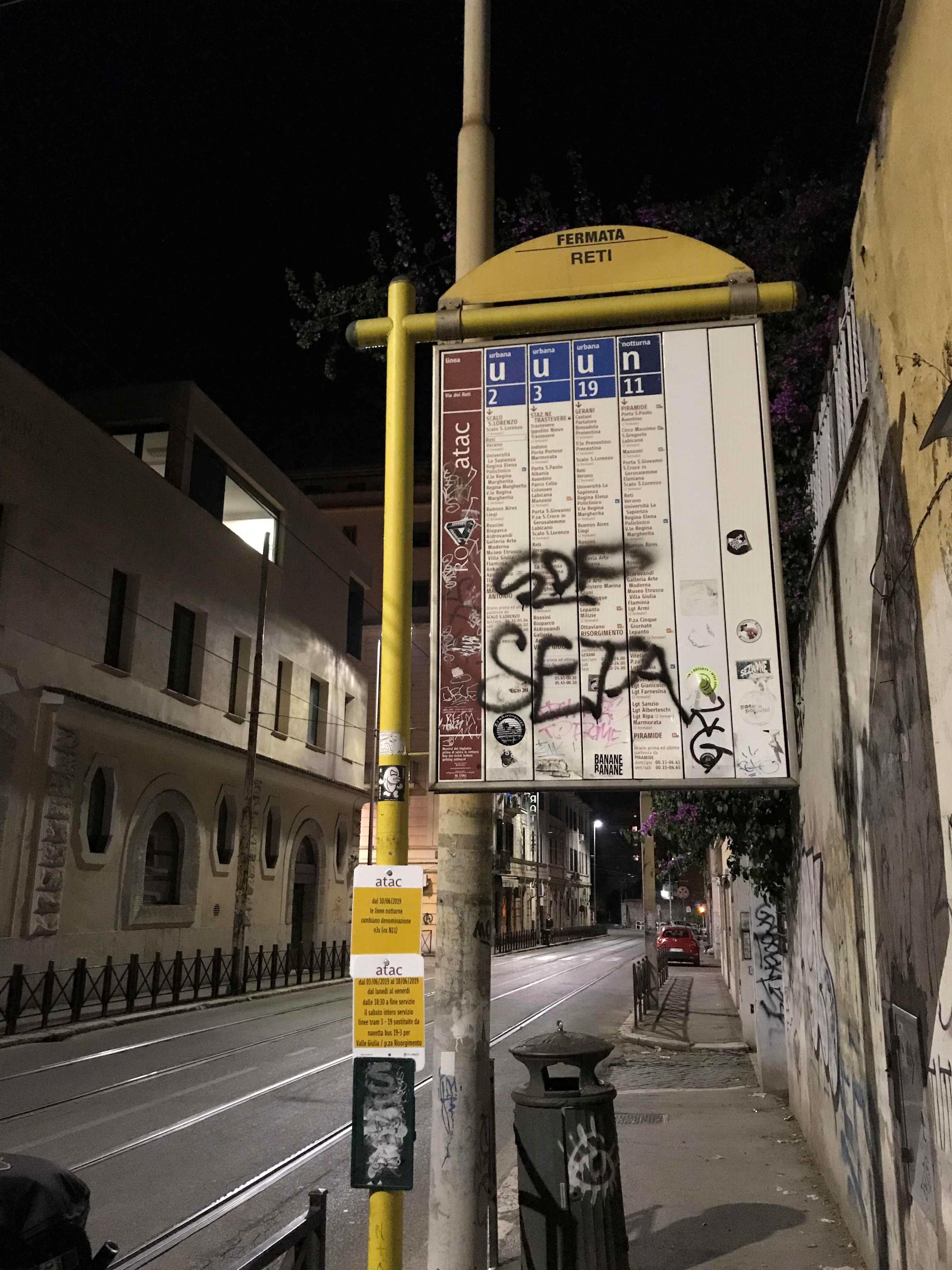
Reti station
 Taken by Anonymous
See Reti station, Roma, on the map
Public transit to Reti station (ID: 71344) in Roma
Looking for directions to Reti in Roma, Italy?
Download the Moovit App to find the current schedule and step-by-step directions for Bus, Light Rail, Metro or Train routes that pass through Reti.
Looking for the nearest stops closest to Reti ? Check out this list of closest stops to your destination: Sardi; Tiburtina/Marrucini; Verano/De Lollis; Verano; Roma | De Lollis Street.
Bus: 163, 492, 542, 71, C2, N3D, C3, N3S, 448, 88, 545.Train: FL5, R.Metro: A.Light Rail: 3.
We make riding on public transit to Reti easy, which is why over 1.7 billion users, including users in Roma trust Moovit as the best app for public transit.
Use the app to navigate to popular places including to the airport, hospital, stadium, grocery store, mall, coffee shop, school, college, and university.
Reti station’s code is 71344
The first line to this station is N3S, at 3:25 AM, and the last line is N3S at 2:52 AM.
126 Via dei Volsci, Roma, Italy
This station serves ATAC and ATAC’s lines
Popular routes from Reti station, Roma
- To Cavalieri di Malta Medical Clinic,
- To Sapienza University - Marco Polo Campus,
- To Tagliacozzo Hospital Center,
- To San Raffaele Montecompatri,
- To Israelitic Hospital,
- To Clara Franceschini Physiotherapy Rehabilitation Institute,
- To Aviocaipoli Nino Petrini,
- To Testaccio,
- To Rome East Airfield,
- To Cecchignola
- Sardi,
- Tiburtina/Marrucini,
- Verano,
- Roma | De Lollis Street
Bus stops near Reti stop
- Verano/De Lollis
Light Rail station near Reti station
- Prenestina/Atac Workshops,
- Prenestina/Tenuta Mistica,
- Salvo D'Acquisto Avenue 1,
- Provincial Road 77b, Spinoretico,
- Frosinone | I.I.S. Turriziani,
- Poggio Nativo | Casali,
- Bracciano,
- Portuense/La Loggia,
- Sonnino/San Gallicano (Hospital),
- Casal Del Marmo/Ottavia (FL3),
- Settebagni/Vigne Nuove,
- Valle Giulia,
- Claudia/Colosseum,
- Aurelia/Richelmy,
- Porta Metronia,
- Colli Portuensi/Artom,
- Albano Laziale,
- Po/Simeto,
- Ladispoli, Europa Avenue Conad Mare,
- Aurelia/Madonna Del Riposo
Popular public transit stations in Roma
Get around Roma by public transit!
Traveling around Roma has never been so easy. See step by step directions as you travel to any attraction, street or major public transit station. View bus and train schedules, arrival times, service alerts and detailed routes on a map, so you know exactly how to get to anywhere in Roma.
When traveling to any destination around Roma use Moovit's Live Directions with Get Off Notifications to know exactly where and how far to walk, how long to wait for your line, and how many stops are left. Moovit will alert you when it's time to get off — no need to constantly re-check whether yours is the next stop.
Wondering how to use public transit in Roma or how to pay for public transit in Roma? Moovit public transit app can help you navigate your way with public transit easily, and at minimum cost. It includes public transit fees, ticket prices, and costs. Looking for a map of Roma public transit lines? Moovit public transit app shows all public transit maps in Roma with all Bus, Train, Metro, Light Rail, Ferry, Funicular and Gondola routes and stops on an interactive map.
Rome and Lazio has 7 transit type(s), including: Bus, Train, Metro, Light Rail, Ferry, Funicular and Gondola, operated by several transit agencies, including ATAC, Cotral, Trenitalia, Troiani Transportation Services, BIS, ATR Mobility, Tuscia, Shuttle, Seatour, Troiani Bus Lines, CSC Mobility, Terravision, ATRAL, Tambus and Sitbus