How to get to Rfv Horkheim by bus?
Click on the bus route to see step by step directions with maps, line arrival times and updated time schedules.
How to get to Rfv Horkheim by train?
Click on the train route to see step by step directions with maps, line arrival times and updated time schedules.
Train stations near Rfv Horkheim
Bus lines to Rfv Horkheim
What are the closest stations to Rfv Horkheim?
The closest stations to Rfv Horkheim are:
- Horkheim Kelter is 622 meters away, 9 min walk.
- Klingenberg Tränkgasse is 1532 meters away, 20 min walk.
- Nordheim (Württ) Gleis 1 is 2751 meters away, 35 min walk.
- Nordheim is 2754 meters away, 36 min walk.
- Nordheim (Württ) is 2754 meters away, 36 min walk.
- Böckingen West is 4667 meters away, 60 min walk.
Which train line stops near Rfv Horkheim?
MEX 12 (Tübingen Hauptbahnhof)
Which bus lines stop near Rfv Horkheim?
These bus lines stop near Rfv Horkheim: 31, 662.
What’s the nearest bus station to Rfv Horkheim?
The nearest bus station to Rfv Horkheim is Horkheim Kelter. It’s a 9 min walk away.
What time is the first train to Rfv Horkheim?
The MEX 18 is the first train that goes to Rfv Horkheim. It stops nearby at 4:34 AM.
What time is the last train to Rfv Horkheim?
The S4 is the last train that goes to Rfv Horkheim. It stops nearby at 1:03 AM.
What time is the first bus to Rfv Horkheim?
The FW 1 is the first bus that goes to Rfv Horkheim. It stops nearby at 4:10 AM.
What time is the last bus to Rfv Horkheim?
The 661 is the last bus that goes to Rfv Horkheim. It stops nearby at 1:00 AM.
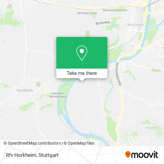
See Rfv Horkheim on the map
Public Transportation to Rfv Horkheim
Wondering how to get to Rfv Horkheim? Moovit helps you find the best way to get to Rfv Horkheim with step-by-step directions from the nearest public transit station.
Moovit provides free maps and live directions to help you navigate through your city. View schedules, routes, timetables, and find out how long does it take to get to Rfv Horkheim in real time.
Looking for the nearest stop or station to Rfv Horkheim? Check out this list of stops closest to your destination: Horkheim Kelter; Klingenberg Tränkgasse; Nordheim (Württ) Gleis 1; Nordheim; Nordheim (Württ); Böckingen West.
Train: MEX 12, RE 8, MEX 18, RE8, MEX12, MEX18, RB8, MEX12, MEX18, S4, S41, S42.Bus: 31, 662, 32, 33, FW 1.
Want to see if there’s another route that gets you there at an earlier time? Moovit helps you find alternative routes or times. Get directions from and directions to Rfv Horkheim easily from the Moovit App or Website.
We make riding to Rfv Horkheim easy, which is why over 1.5 million users, including users in Horkheim, trust Moovit as the best app for public transit. You don’t need to download an individual bus app or train app, Moovit is your all-in-one transit app that helps you find the best bus time or train time available.
For information on prices of bus, train and light rail, costs and ride fares to Rfv Horkheim, please check the Moovit app.
Use the app to navigate to popular places including to the airport, hospital, stadium, grocery store, mall, coffee shop, school, college, and university.
Rfv Horkheim Address: Kelterweg 41 74081 Heilbronn street in Horkheim
- Reiterhof Horkheim Betriebsgesellschaft,
- Ionut-Adrian Nistor Gaststätte,
- Stephan Burock Baumpflege,
- Eberling Verwaltungs,
- Fabelhaft Geschichten,
- Gemüse-U.Obstmarkt Bauer,
- Bauschlosserei Walter, Enver Doberdolani,
- Jürgen Knauer,
- Burg Horkheim,
- Johanniter-Unfall-Hilfe e.V. - Dienststelle Heilbronn,
- Norbert Szpak Seminare & Coaching,
- Physiotherapie Siepe,
- Die Perle - Haushaltshilfen,
- Arbeits- und Wohnstätten GmbH Therapeutikum Heilbronn,
- Eisautomat Horkheim,
- Haule Andreas Verkehrstechnik,
- Wormser's Hofladen,
- Bueckle Corporate Fashion,
- Dexheimer,
- Dr. med. Wolf Bellmann
Places Near Rfv Horkheim
- Mettingen Eros-Center Puff Laufhaus, Esslingen Am Neckar,
- FlixBus Haltestelle, Stuttgart,
- Hauptbahnhof Stuttgart, Stuttgart-Mitte,
- Porsche-Arena, Bad Cannstatt,
- Mercedes-Benz Museum (Mercedes Museum Stuttgart), Bad Cannstatt,
- Gasometer Pforzheim, Pforzheim,
- Porsche Museum, Zuffenhausen,
- SI-Centrum, Möhringen,
- Geilhaus Haus 33a, Reutlingen-Betzingen,
- Waldfriedhof, Degerloch,
- Pariser Platz Stuttgart, Stuttgart-Mitte,
- Klinikum Stuttgart - Katharinenhospital, Stuttgart-Mitte,
- Schleyerhalle, Bad Cannstatt,
- Gleis 101/102 (tief), Stuttgart-Mitte,
- Hanns-Martin-Schleyer-Halle, Bad Cannstatt,
- Im Wizemann (Halle), Bad Cannstatt,
- Wilhelma (U-Bahn Wilhelma), Bad Cannstatt,
- Hanns-Martin-Schleyer-Halle (Stuttgart Hans-Martin-Schleyerhalle), Bad Cannstatt,
- Mercedes-Benz Museum, Bad Cannstatt,
- Marmorsaal Im Weissenburgpark, Stuttgart-Süd
How to get to popular places in Stuttgart with public transit
Get around Horkheim by public transit!
Traveling around Horkheim has never been so easy. See step by step directions as you travel to any attraction, street or major public transit station. View bus and train schedules, arrival times, service alerts and detailed routes on a map, so you know exactly how to get to anywhere in Horkheim.
When traveling to any destination around Horkheim use Moovit's Live Directions with Get Off Notifications to know exactly where and how far to walk, how long to wait for your line, and how many stops are left. Moovit will alert you when it's time to get off — no need to constantly re-check whether yours is the next stop.
Wondering how to use public transit in Horkheim or how to pay for public transit in Horkheim? Moovit public transit app can help you navigate your way with public transit easily, and at minimum cost. It includes public transit fees, ticket prices, and costs. Looking for a map of Horkheim public transit lines? Moovit public transit app shows all public transit maps in Horkheim with all Bus, Train, Subway, Light Rail, Ferry, S-Bahn and Funicular routes and stops on an interactive map.
Stuttgart has 7 transit type(s), including: Bus, Train, Subway, Light Rail, Ferry, S-Bahn and Funicular, operated by several transit agencies, including SSB - Stadtbahn, SSB, SSB - Seilbahn / Zacke, S-Bahn Stuttgart, Rhein-Neckar-Verkehr GmbH (rnv), Karlsruher Verkehrsverbund, DB AG, DB Regiobus BW, Arverio Baden-Württemberg GmbH, DB RegioNetz Verkehrs GmbH Westfrankenbahn, DB Regio AG Baden-Württemberg, Südwestdeutsche Verkehrs-AG, DB Regio AG Mitte Region Hessen, DB and Bodensee-Oberschwaben-Bahn