Ridge Av & Susquehanna Av stop - Monday schedule
| Line | Direction | Time |
|---|---|---|
| 61 | Manayunk | 5:54 AM |
| 61 | Manayunk | 6:24 AM |
| 61 | Manayunk | 6:54 AM |
| 61 | Manayunk | 7:14 AM |
| 61 | Manayunk | 7:28 AM |
| 61 | Manayunk | 7:41 AM |
| 61 | Manayunk | 7:54 AM |
| 61 | Manayunk | 8:04 AM |
| 61 | Manayunk | 8:14 AM |
| 61 | Manayunk | 8:24 AM |
| 61 | Manayunk | 8:34 AM |
| 61 | Manayunk | 8:44 AM |
| 61 | Manayunk | 8:54 AM |
| 61 | Manayunk | 9:04 AM |
| 61 | Manayunk | 9:16 AM |
| 61 | Manayunk | 9:28 AM |
| 61 | Manayunk | 9:43 AM |
| 61 | Manayunk | 9:59 AM |
| 61 | Manayunk | 10:15 AM |
| 61 | Manayunk | 10:35 AM |
| 61 | Manayunk | 10:55 AM |
| 61 | Manayunk | 11:20 AM |
| 61 | Manayunk | 11:45 AM |
| 61 | Manayunk | 12:10 PM |
| 61 | Manayunk | 12:35 PM |
Directions to Ridge Av & Susquehanna Av stop (Philadelphia) with public transit
The following transit lines have routes that pass near Ridge Av & Susquehanna Av
 Bus: 32, 39, 54, 61, 7.
- Train: CHE, FOX, LAN, TRE.
- Metro: G1.
How to get to Ridge Av & Susquehanna Av stop by bus?
Click on the bus route to see step by step directions with maps, line arrival times and updated time schedules.
How to get to Ridge Av & Susquehanna Av stop by train?
Click on the train route to see step by step directions with maps, line arrival times and updated time schedules.
How to get to Ridge Av & Susquehanna Av stop by metro?
Click on the metro route to see step by step directions with maps, line arrival times and updated time schedules.
Bus stops near Ridge Av & Susquehanna Av stop in Philadelphia
- Ridge Av & 31st St , 2 min walk,
- Dauphin St & 32nd St, 4 min walk,
- 33rd St & Susquehanna Av, 4 min walk,
Metro stations near Ridge Av & Susquehanna Av station in Philadelphia
- Girard Av & 29th St, 23 min walk,
Bus lines to Ridge Av & Susquehanna Av stop in Philadelphia
- 61, Manayunk,
- 7, 21st-Oregon,
- 39, Richmond-Cumberland,
- 49, 29th-Snyder,
- 32, Ridge-Lyceum Via Lemon Hill,
What are the closest stations to Ridge Av & Susquehanna Av?
The closest stations to Ridge Av & Susquehanna Av are:
- Ridge Av & 31st St stop is 70 yards away, 2 min walk.
- Dauphin St & 32nd St stop is 255 yards away, 4 min walk.
- 33rd St & Susquehanna Av stop is 303 yards away, 4 min walk.
- Girard Av & 29th St station is 1991 yards away, 23 min walk.
Which bus lines stop near Ridge Av & Susquehanna Av?
These bus lines stop near Ridge Av & Susquehanna Av: 32, 39, 54, 61.
Which train lines stop near Ridge Av & Susquehanna Av?
These train lines stop near Ridge Av & Susquehanna Av: CHE, FOX, LAN, TRE.
Which metro line stops near Ridge Av & Susquehanna Av?
G1 (63rd-Girard)
What’s the nearest metro station to Ridge Av & Susquehanna Av in Philadelphia?
The nearest metro station to Ridge Av & Susquehanna Av in Philadelphia is Girard Av & 29th St. It’s a 23 min walk away.
What’s the nearest bus station to Ridge Av & Susquehanna Av in Philadelphia?
The nearest bus station to Ridge Av & Susquehanna Av in Philadelphia is Ridge Av & 31st St. It’s a 2 min walk away.
Ridge Av & Susquehanna Av station
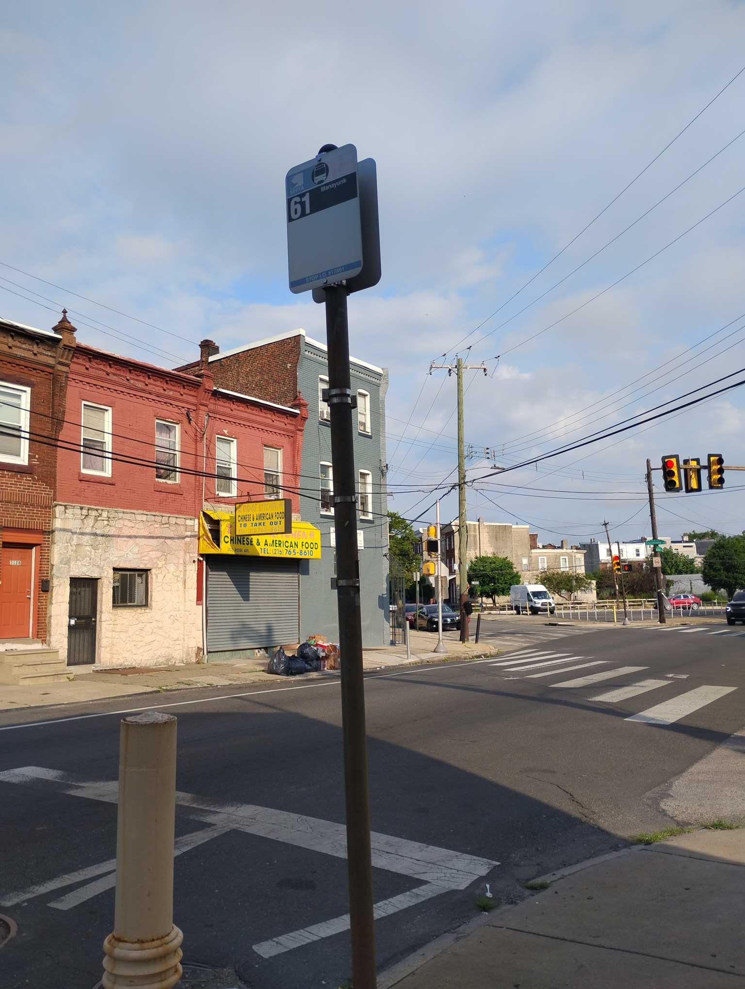 Taken by Anonymous
See Ridge Av & Susquehanna Av stop, Philadelphia, on the map
Public transit to Ridge Av & Susquehanna Av stop (ID: 17891) in Philadelphia
Looking for directions to Ridge Av & Susquehanna Av in Philadelphia, United States?
Download the Moovit App to find the current schedule and step-by-step directions for Bus, Metro or Train routes that pass through Ridge Av & Susquehanna Av.
Looking for the nearest stops closest to Ridge Av & Susquehanna Av ? Check out this list of closest stops to your destination: Ridge Av & 31st St ; Dauphin St & 32nd St; 33rd St & Susquehanna Av; Girard Av & 29th St.
Bus: 32, 39, 54, 61, 7, 49.Train: CHE, FOX, LAN, TRE.Metro: G1.
We make riding on public transit to Ridge Av & Susquehanna Av easy, which is why over 1.7 billion users, including users in Philadelphia trust Moovit as the best app for public transit.
Use the app to navigate to popular places including to the airport, hospital, stadium, grocery store, mall, coffee shop, school, college, and university.
Ridge Av & Susquehanna Av stop’s code is 17891
The first line to this stop is 61, at 5:54 AM, and the last line is 61 at 1:59 AM.
3101-25 Ridge Ave, Philadelphia, PA, USA
This stop serves SEPTA’s lines
- Ridge Av & 31st St ,
- Dauphin St & 32nd St,
- 33rd St & Susquehanna Av
Bus stops near Ridge Av & Susquehanna Av stop
- Girard Av & 29th St
Metro station near Ridge Av & Susquehanna Av station
- Conshohocken,
- Arch St & 5th St,
- Frankford Av & Ruan St ,
- Allegheny Av & 6th St,
- Ridge Rd & Market St,
- Walnut St & 47th St,
- Spring Garden St & 31st St,
- Broad St & Wyoming Av,
- Umbria St & Fountain St ,
- Broad St & Mckean St,
- Market St at 7th St,
- Walnut St & 40th St,
- Mt Pleasant Av & Germantown Av ,
- Broad St & Roosevelt Blvd,
- 60th St & Oxford St,
- 4th St & Wolf St,
- Walnut St & 33rd St,
- Medford Rd & Belgreen Rd,
- Domino Ln & Ridge Av - Fs,
- JFK Blvd & 19th St
Popular public transit stations in Philadelphia
Get around Philadelphia by public transit!
Traveling around Philadelphia has never been so easy. See step by step directions as you travel to any attraction, street or major public transit station. View bus and train schedules, arrival times, service alerts and detailed routes on a map, so you know exactly how to get to anywhere in Philadelphia.
When traveling to any destination around Philadelphia use Moovit's Live Directions with Get Off Notifications to know exactly where and how far to walk, how long to wait for your line, and how many stops are left. Moovit will alert you when it's time to get off — no need to constantly re-check whether yours is the next stop.
Wondering how to use public transit in Philadelphia or how to pay for public transit in Philadelphia? Moovit public transit app can help you navigate your way with public transit easily, and at minimum cost. It includes public transit fees, ticket prices, and costs. Looking for a map of Philadelphia public transit lines? Moovit public transit app shows all public transit maps in Philadelphia with all Bus, Train, Metro, Light Rail and Cable Car routes and stops on an interactive map.
Philadelphia has 5 transit type(s), including: Bus, Train, Metro, Light Rail and Cable Car, operated by several transit agencies, including SEPTA Subway, SEPTA Rail, SEPTA, SEPTA Trolley, NJ Transit Rail, NJ Transit, Port Authority Transit Corporation, Navy Yard, Penn Transit, Drexel University, Pottstown Area Rapid Transit (PART), Fullington Tours, Chescobus, Amtrak and Greyhound-us