How to get to Ridgewood by bus?
Click on the bus route to see step by step directions with maps, line arrival times and updated time schedules.
From BAPS Shri Swaminarayan Mandir, Queens
72 minFrom Broadway Theatre, Manhattan
78 minFrom Hammerstein Ballroom, Manhattan
90 minFrom Little Italy, Manhattan
65 minFrom Ed Sullivan Theater, Manhattan
81 minFrom Statue of Liberty Ferry, Manhattan
108 minFrom Conrad New York Downtown, Manhattan
119 minFrom New York Supreme Court, Manhattan
73 minFrom City Hall 141 Worth Street, Manhattan
112 minFrom Century 21 Department Store, Manhattan
115 min
How to get to Ridgewood by train?
Click on the train route to see step by step directions with maps, line arrival times and updated time schedules.
How to get to Ridgewood by subway?
Click on the subway route to see step by step directions with maps, line arrival times and updated time schedules.
From BAPS Shri Swaminarayan Mandir, Queens
86 minFrom Broadway Theatre, Manhattan
45 minFrom Hammerstein Ballroom, Manhattan
42 minFrom Little Italy, Manhattan
43 minFrom Ed Sullivan Theater, Manhattan
45 minFrom Statue of Liberty Ferry, Manhattan
52 minFrom Conrad New York Downtown, Manhattan
48 minFrom New York Supreme Court, Manhattan
43 minFrom City Hall 141 Worth Street, Manhattan
44 minFrom Century 21 Department Store, Manhattan
43 min
Bus stops near Ridgewood in Queens
Subway station near Ridgewood in Queens
- Myrtle-Wyckoff Avs, 11 min walk,VIEW
Bus lines to Ridgewood in Queens
What are the closest stations to Ridgewood?
The closest stations to Ridgewood are:
- Forest Av/Myrtle Av is 182 yards away, 3 min walk.
- Myrtle Av/Forest Av is 187 yards away, 3 min walk.
- Summerfield St/Seneca Av is 385 yards away, 5 min walk.
- Myrtle-Wyckoff Avs is 841 yards away, 11 min walk.
Which bus lines stop near Ridgewood?
These bus lines stop near Ridgewood: B20, Q39.
Which train line stops near Ridgewood?
CITY TERMINAL ZONE (Atlantic Terminal)
Which subway lines stop near Ridgewood?
These subway lines stop near Ridgewood: A, G, L.
What’s the nearest subway station to Ridgewood in Queens?
The nearest subway station to Ridgewood in Queens is Myrtle-Wyckoff Avs. It’s a 11 min walk away.
What’s the nearest bus station to Ridgewood in Queens?
The nearest bus stations to Ridgewood in Queens are Forest Av/Myrtle Av and Myrtle Av/Forest Av. The closest one is a 3 min walk away.
What time is the first subway to Ridgewood in Queens?
The L is the first subway that goes to Ridgewood in Queens. It stops nearby at 3:01 AM.
What time is the last subway to Ridgewood in Queens?
The L is the last subway that goes to Ridgewood in Queens. It stops nearby at 3:10 AM.
What time is the first bus to Ridgewood in Queens?
The Q39 is the first bus that goes to Ridgewood in Queens. It stops nearby at 3:02 AM.
What time is the last bus to Ridgewood in Queens?
The Q39 is the last bus that goes to Ridgewood in Queens. It stops nearby at 3:17 AM.
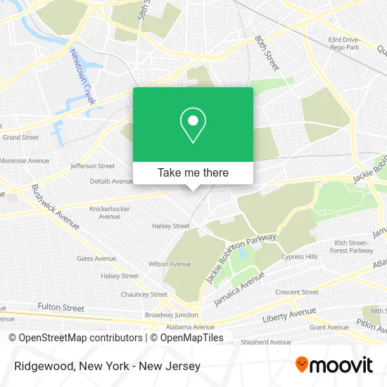
See Ridgewood, Queens, on the map
Public Transit to Ridgewood in Queens
Wondering how to get to Ridgewood in Queens? Moovit helps you find the best way to get to Ridgewood with step-by-step directions from the nearest public transit station.
Moovit provides free maps and live directions to help you navigate through your city. View schedules, routes, timetables, and find out how long does it take to get to Ridgewood in real time.
Looking for the nearest stop or station to Ridgewood? Check out this list of stops closest to your destination: Forest Av/Myrtle Av; Myrtle Av/Forest Av; Summerfield St/Seneca Av; Myrtle-Wyckoff Avs.
Bus: B20, Q39, Q55.Train: CITY TERMINAL ZONE.Subway: A, G, L, M.
Want to see if there’s another route that gets you there at an earlier time? Moovit helps you find alternative routes or times. Get directions from and directions to Ridgewood easily from the Moovit App or Website.
We make riding to Ridgewood easy, which is why over 1.5 million users, including users in Queens, trust Moovit as the best app for public transit. You don’t need to download an individual bus app or train app, Moovit is your all-in-one transit app that helps you find the best bus time or train time available.
For information on prices of subway, bus and train, costs and ride fares to Ridgewood, please check the Moovit app.
Use the app to navigate to popular places including to the airport, hospital, stadium, grocery store, mall, coffee shop, school, college, and university.
Location: Queens, New York - New Jersey
- Ridgewood Thrift Inc,
- Skechers Myrtle Avenue,
- Weil Podiatry Of New York,
- The Phone Parts,
- Good Neighbors Supermarket,
- Bossbabesmedspany,
- Rosse Nails,
- Fresh N Save Marketplace,
- Jane Eyre Nails,
- Sky Beauty Spa,
- Pomidoro Inc,
- Brunch Spot Nyc,
- New Rainbow Spa,
- Canaj Management Llc,
- Finecare Medical Lab Inc,
- Antoinette's Cleaners and Custom,
- Feelsnyc,
- Biedronka,
- Walgreens #17876,
- Myrtle's Clayhouse
Places Near Ridgewood (Queens)
- 3 Stone St, Manhattan,
- 26 Federal Plaza, Manhattan,
- 66 John Street, Manhattan,
- 1 Police Plaza, Manhattan,
- 911 Memorial, Manhattan,
- Katz's Deli, Manhattan,
- Chinatown, Manhattan,
- Hudson Yards, Manhattan,
- 376 Hudson Street, Manhattan,
- 111 Centre New York City Supreme Court, Manhattan,
- Wall Street, Manhattan,
- SoHo, Manhattan,
- Rockefeller Center, Manhattan,
- Bellevue Hospital, Manhattan,
- Queens Center Mall, Queens,
- Times Square, Manhattan,
- San Gennaro Feast, Manhattan,
- Mountainside Hospital, Glen Ridge,
- Pier 83, Manhattan,
- qqqq, Manhattan
How to get to popular places in New York - New Jersey with public transit
Get around Queens by public transit!
Traveling around Queens has never been so easy. See step by step directions as you travel to any attraction, street or major public transit station. View bus and train schedules, arrival times, service alerts and detailed routes on a map, so you know exactly how to get to anywhere in Queens.
When traveling to any destination around Queens use Moovit's Live Directions with Get Off Notifications to know exactly where and how far to walk, how long to wait for your line, and how many stops are left. Moovit will alert you when it's time to get off — no need to constantly re-check whether yours is the next stop.
Wondering how to use public transit in Queens or how to pay for public transit in Queens? Moovit public transit app can help you navigate your way with public transit easily, and at minimum cost. It includes public transit fees, ticket prices, and costs. Looking for a map of Queens public transit lines? Moovit public transit app shows all public transit maps in Queens with all Bus, Train, Subway, Light Rail, Ferry and Cable Car routes and stops on an interactive map.
New York - New Jersey has 6 transit type(s), including: Bus, Train, Subway, Light Rail, Ferry and Cable Car, operated by several transit agencies, including MTA Subway, Metro-North Railroad, LIRR, PATH, MTA New York City Transit - Express routes, MTA Bus, NJ Transit, NYC Ferry, NICE bus, Bee-Line Bus, NJ Transit Rail, Norwalk Transit District, Hartford Line, River Valley Transit and HART