Riverside Drive/Ramblewood Drive stop - Monday schedule
| Line | Direction | Time |
|---|---|---|
| 62 | Westview - University | 6:25 AM |
| 62 | Westview - University | 7:09 AM |
| 62 | Westview - University | 7:45 AM |
| 62 | Westview - University | 8:23 AM |
| 62 | Westview - University | 9:02 AM |
| 62 | Westview - University | 9:41 AM |
| 62 | Westview - University | 10:20 AM |
| 62 | Westview - University | 10:59 AM |
| 62 | Westview - University | 11:37 AM |
| 62 | Westview - University | 12:16 PM |
| 62 | Westview - University | 12:55 PM |
| 62 | Westview - University | 1:34 PM |
| 62 | Westview - University | 2:13 PM |
| 62 | Westview - University | 2:52 PM |
| 62 | Westview - University | 3:31 PM |
| 62 | Westview - University | 4:14 PM |
| 62 | Westview - University | 4:51 PM |
| 62 | Westview - University | 5:30 PM |
| 62 | Westview - University | 6:09 PM |
| 62 | Westview - University | 6:49 PM |
| 62 | Westview - University | 7:22 PM |
| 62 | Westview - University | 7:58 PM |
| 62 | Westview - University | 8:34 PM |
| 62 | Westview - University | 9:08 PM |
| 62 | Westview - University | 9:43 PM |
Directions to Riverside Drive / Ramblewood Drive stop (Coral Springs-Margate) with public transit
The following transit lines have routes that pass near Riverside Drive / Ramblewood Drive
 Bus: 42, 62.
How to get to Riverside Drive / Ramblewood Drive stop by bus?
Click on the bus route to see step by step directions with maps, line arrival times and updated time schedules.
Bus stops near Riverside Drive / Ramblewood Drive stop in Coral Springs-Margate
- Riverside Drive/Northwest 7th Street, 4 min walk,
- Atlantic Boulevard/Riverside Drive, 11 min walk,
Bus lines to Riverside Drive / Ramblewood Drive stop in Coral Springs-Margate
- 62, Westview - University,
- 42, Atlantic - Coral Ridge Via Northeast Transit Center,
What are the closest stations to Riverside Drive / Ramblewood Drive?
The closest stations to Riverside Drive / Ramblewood Drive are:
- Riverside Drive/Northwest 7th Street stop is 258 yards away, 4 min walk.
- Atlantic Boulevard/Riverside Drive stop is 868 yards away, 11 min walk.
Which bus lines stop near Riverside Drive / Ramblewood Drive?
These bus lines stop near Riverside Drive / Ramblewood Drive: 42, 62.
What’s the nearest bus station to Riverside Drive / Ramblewood Drive in Coral Springs-Margate?
The nearest bus station to Riverside Drive / Ramblewood Drive in Coral Springs-Margate is Riverside Drive/Northwest 7th Street. It’s a 4 min walk away.
What time is the first bus to Riverside Drive / Ramblewood Drive in Coral Springs-Margate?
The 42 is the first bus that goes to Riverside Drive / Ramblewood Drive in Coral Springs-Margate. It stops nearby at 5:18 AM.
What time is the last bus to Riverside Drive / Ramblewood Drive in Coral Springs-Margate?
The 62 is the last bus that goes to Riverside Drive / Ramblewood Drive in Coral Springs-Margate. It stops nearby at 11:55 PM.
Riverside Drive / Ramblewood Drive station
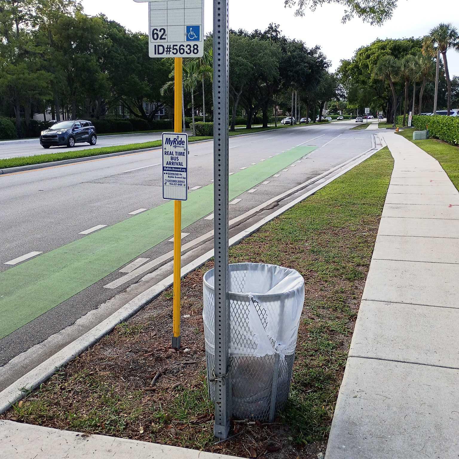 Taken by Anonymous
See Riverside Drive / Ramblewood Drive stop, Coral Springs-Margate, on the map
Public transit to Riverside Drive/Ramblewood Drive stop (ID: 5638) in Coral Springs-Margate
Looking for directions to Riverside Drive / Ramblewood Drive in Coral Springs-Margate, United States?
Download the Moovit App to find the current schedule and step-by-step directions for Bus routes that pass through Riverside Drive / Ramblewood Drive.
Looking for the nearest stops closest to Riverside Drive / Ramblewood Drive ? Check out this list of closest stops to your destination: Riverside Drive/Northwest 7th Street; Atlantic Boulevard/Riverside Drive.
Bus: 42, 62.
We make riding on public transit to Riverside Drive / Ramblewood Drive easy, which is why over 1.7 billion users, including users in Coral Springs-Margate trust Moovit as the best app for public transit.
Use the app to navigate to popular places including to the airport, hospital, stadium, grocery store, mall, coffee shop, school, college, and university.
Riverside Drive/Ramblewood Drive stop’s code is 5638
The first line to this stop is 62, at 6:25 AM, and the last line is 62 at 11:53 PM.
Riverside Drive, Coral Springs, FL, USA
This stop serves Broward County Transit’s lines
Popular routes from Riverside Drive / Ramblewood Drive stop, Coral Springs-Margate
- Riverside Drive/Northwest 7th Street,
- Atlantic Boulevard/Riverside Drive
Bus stops near Riverside Drive/Ramblewood Drive stop
- Taft Street/Douglas Road,
- LAKE WORTH RD at US-441/SR-7,
- Nw 27 Av & 113 St,
- SW Gatlin Blvd & Walmart,
- Collins Av & 65 St,
- E 49 St & E 8 Av,
- Nw 199 St & Nw 52 Av,
- Sw 40 St & Le Jeune Rd,
- US-441 at GLADES RD,
- Bayfront Park,
- W BOCA MED CTR at HSP MAIN ENT,
- 10TH AVE N at KIRK RD,
- WPB ITC at BAY G,
- DIXIE HWY at FEDERAL HWY,
- Se 2 St & Se 3 Av,
- Biscayne Blvd & Ne 15 St,
- Sw 140 Av @ Approx Sw 278 St,
- Coconut Grove,
- WPB ITC at BAY P,
- MILITARY TRL at BEAR LAKES CT
Popular public transit stations in Coral Springs-Margate
Get around Coral Springs-Margate by public transit!
Traveling around Coral Springs-Margate has never been so easy. See step by step directions as you travel to any attraction, street or major public transit station. View bus and train schedules, arrival times, service alerts and detailed routes on a map, so you know exactly how to get to anywhere in Coral Springs-Margate.
When traveling to any destination around Coral Springs-Margate use Moovit's Live Directions with Get Off Notifications to know exactly where and how far to walk, how long to wait for your line, and how many stops are left. Moovit will alert you when it's time to get off — no need to constantly re-check whether yours is the next stop.
Wondering how to use public transit in Coral Springs-Margate or how to pay for public transit in Coral Springs-Margate? Moovit public transit app can help you navigate your way with public transit easily, and at minimum cost. It includes public transit fees, ticket prices, and costs. Looking for a map of Coral Springs-Margate public transit lines? Moovit public transit app shows all public transit maps in Coral Springs-Margate with all Bus, Train, Light Rail and Ferry routes and stops on an interactive map.
Miami has 4 transit type(s), including: Bus, Train, Light Rail and Ferry, operated by several transit agencies, including Broward County Transit, Miami-Dade Transit, Metrorail, Palm Tran, Tri-Rail, Brightline, MARTY, City of Homestead Trolley, Key West Transit, Treasure Coast Connector, GoLine IRT, Amtrak, Greyhound-us, FlixBus-us and Aventura Express Shuttle Bus