How to get to Rl Synergy sp. z o.o. Sp.K by train?
Click on the train route to see step by step directions with maps, line arrival times and updated time schedules.
Bus stops near Rl Synergy sp. z o.o. Sp.K in Warsaw
Light Rail stations near Rl Synergy sp. z o.o. Sp.K in Warsaw
- Cebertowicza 02, 4 min walk,VIEW
Bus lines to Rl Synergy sp. z o.o. Sp.K in Warsaw
What are the closest stations to Rl Synergy sp. z o.o. Sp.K?
The closest stations to Rl Synergy sp. z o.o. Sp.K are:
- Milskiego 01 is 251 meters away, 4 min walk.
- Cebertowicza 02 is 266 meters away, 4 min walk.
- Osiedle Jary 02 is 498 meters away, 7 min walk.
- Wilanowska 03 is 507 meters away, 7 min walk.
- Kopeckiego 01 is 678 meters away, 10 min walk.
Which train line stops near Rl Synergy sp. z o.o. Sp.K?
REG (Elbląg)
Which light rail lines stop near Rl Synergy sp. z o.o. Sp.K?
These light rail lines stop near Rl Synergy sp. z o.o. Sp.K: 11, 2.
What’s the nearest light rail station to Rl Synergy sp. z o.o. Sp.K in Warsaw?
The nearest light rail station to Rl Synergy sp. z o.o. Sp.K in Warsaw is Cebertowicza 02. It’s a 4 min walk away.
What’s the nearest bus station to Rl Synergy sp. z o.o. Sp.K in Warsaw?
The nearest bus station to Rl Synergy sp. z o.o. Sp.K in Warsaw is Milskiego 01. It’s a 4 min walk away.
What time is the first light rail to Rl Synergy sp. z o.o. Sp.K in Warsaw?
The 11 is the first light rail that goes to Rl Synergy sp. z o.o. Sp.K in Warsaw. It stops nearby at 4:19 AM.
What time is the last light rail to Rl Synergy sp. z o.o. Sp.K in Warsaw?
The 6 is the last light rail that goes to Rl Synergy sp. z o.o. Sp.K in Warsaw. It stops nearby at 11:51 PM.
What time is the first bus to Rl Synergy sp. z o.o. Sp.K in Warsaw?
The 174 is the first bus that goes to Rl Synergy sp. z o.o. Sp.K in Warsaw. It stops nearby at 4:36 AM.
What time is the last bus to Rl Synergy sp. z o.o. Sp.K in Warsaw?
The N14 is the last bus that goes to Rl Synergy sp. z o.o. Sp.K in Warsaw. It stops nearby at 3:44 AM.
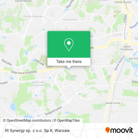
See Rl Synergy sp. z o.o. Sp.K, Warsaw, on the map
Public Transit to Rl Synergy sp. z o.o. Sp.K in Warsaw
Wondering how to get to Rl Synergy sp. z o.o. Sp.K in Warsaw? Moovit helps you find the best way to get to Rl Synergy sp. z o.o. Sp.K with step-by-step directions from the nearest public transit station.
Moovit provides free maps and live directions to help you navigate through your city. View schedules, routes, timetables, and find out how long does it take to get to Rl Synergy sp. z o.o. Sp.K in real time.
Looking for the nearest stop or station to Rl Synergy sp. z o.o. Sp.K? Check out this list of stops closest to your destination: Milskiego 01; Cebertowicza 02; Osiedle Jary 02; Wilanowska 03; Kopeckiego 01.
Bus: 208, 227, N14, N4, 195, 262, 115, 162, 174, 108.Train: REG.Light Rail: 11, 2.
Want to see if there’s another route that gets you there at an earlier time? Moovit helps you find alternative routes or times. Get directions from and directions to Rl Synergy sp. z o.o. Sp.K easily from the Moovit App or Website.
We make riding to Rl Synergy sp. z o.o. Sp.K easy, which is why over 1.5 million users, including users in Warsaw, trust Moovit as the best app for public transit. You don’t need to download an individual bus app or train app, Moovit is your all-in-one transit app that helps you find the best bus time or train time available.
For information on prices of train, light rail and bus, costs and ride fares to Rl Synergy sp. z o.o. Sp.K, please check the Moovit app.
Use the app to navigate to popular places including to the airport, hospital, stadium, grocery store, mall, coffee shop, school, college, and university.
Rl Synergy sp. z o.o. Sp.K Address: ulica prof. Romualda Cebertowicza, 80-809 Gdańsk street in Warsaw
- Michał Wiśniewski,
- Successmakers Artur Frankowski,
- Zen-Trans Piekarczyk Zenon,
- Stowarzyszenie Garnizon Gdańsk,
- Dawola s.c. Aleksandra Dawluszewicz Dawid Kropidłowski,
- Przedszkole 39,
- Dart Sport,
- Middle Line s.c.,
- Adam Winnicki Software Development,
- Jr-Advise Justyna Rak,
- Zakład Ogólnobudowlany Jerzy Konieczny,
- Monacor-Polska sp. z o.o. Oddział w Gdańsku,
- Teida Grzegorz Dzedzej,
- Mariusz Czajkowski Rts Mar,
- Db Solutions Andrzej Dzedzej,
- Usługi Elektryczne Patryk Ługiewicz,
- Joanna Bestfal,
- Firma Budowlana Ryszard Łopion,
- Kancelaria Radcy Prawnego Roman Kazmierczak,
- Usługi Turystyczne
Places Near Rl Synergy sp. z o.o. Sp.K (Warsaw)
- Cmentarz Bródnowski, Warsaw,
- Szpital Orłowskiego, Warsaw,
- Sejm Rp, Warsaw,
- Wołoska, Warsaw,
- Wołoska-Szpital 01, Warsaw,
- Szpital Czerniakowski, Warsaw,
- Galeria Mokotów, Warsaw,
- Szpital Bielański, Warsaw,
- Postępu, Warsaw,
- Torwar, Warsaw,
- Szaserów - Szpital, Warsaw,
- Centralny Szpital Kliniczny MSWiA ul. Wołoska, Warsaw,
- Domaniewska, Warsaw,
- Instytut Kardiologii w Aninie, Warsaw,
- Banacha - Szpital Kliniczny, Warsaw,
- Stare Miasto, Warsaw,
- Szpital Spartanska, Warsaw,
- PGE Narodowy, Warsaw,
- CH Arkadia, Warsaw,
- Galeria Północna, Warsaw
How to get to popular places in Warsaw with public transit
Get around Warsaw by public transit!
Traveling around Warsaw has never been so easy. See step by step directions as you travel to any attraction, street or major public transit station. View bus and train schedules, arrival times, service alerts and detailed routes on a map, so you know exactly how to get to anywhere in Warsaw.
When traveling to any destination around Warsaw use Moovit's Live Directions with Get Off Notifications to know exactly where and how far to walk, how long to wait for your line, and how many stops are left. Moovit will alert you when it's time to get off — no need to constantly re-check whether yours is the next stop.
Wondering how to use public transit in Warsaw or how to pay for public transit in Warsaw? Moovit public transit app can help you navigate your way with public transit easily, and at minimum cost. It includes public transit fees, ticket prices, and costs. Looking for a map of Warsaw public transit lines? Moovit public transit app shows all public transit maps in Warsaw with all Bus, Train, Metro, Light Rail, Ferry and Cable Car routes and stops on an interactive map.
Warsaw has 6 transit type(s), including: Bus, Train, Metro, Light Rail, Ferry and Cable Car, operated by several transit agencies, including Warszawski Transport Publiczny, Warszawska Kolej Dojazdowa, Koleje Mazowieckie, ZTP Kraków, Miasto Piastów, Miasto Ząbki, Koleje Małopolskie, Komunikacja Miejska Łomianki, Gmina Pruszków, MPK Wrocław, MZDiK Radom, UM w Grodzisku Mazowieckim, UM w Nowym Dworze Mazowieckim, UM Płońsk and Koleje Dolnośląskie