Directions to Robin Post (Hewlett) with public transportation
The following transit lines have routes that pass near Robin Post
 Bus: ELFX, N31, N31X/M, N32.
- Train: FAR ROCKAWAY BRANCH, BABYLON BRANCH, LONG BEACH BRANCH.
How to get to Robin Post by bus?
Click on the bus route to see step by step directions with maps, line arrival times and updated time schedules.
From Belmont Park, Elmont
62 minFrom Nostrand Ave, Brooklyn, Queens
59 minFrom Far Rockaway, NY, Queens
25 minFrom Jamaica, NY, Queens
62 minFrom Jamaica, Queens
63 minFrom 168-46 91st Ave, Queens
69 minFrom Plattduetsche Park, Franklin Square
42 minFrom DMV Jamaica Office, Queens
74 minFrom DMV Jamaica Nys, Queens
74 min
How to get to Robin Post by train?
Click on the train route to see step by step directions with maps, line arrival times and updated time schedules.
Bus stops near Robin Post in Hewlett
Train stations near Robin Post in Hewlett
Bus lines to Robin Post in Hewlett
What are the closest stations to Robin Post?
The closest stations to Robin Post are:
- Broadway + Franklin Ave is 303 yards away, 4 min walk.
- W Broadway + Franklin Ave is 413 yards away, 5 min walk.
- West Broadway Opp Mill Rd. is 662 yards away, 8 min walk.
- W Broadway / Mill is 747 yards away, 9 min walk.
- Cedarhurst is 2102 yards away, 25 min walk.
- Valley Stream is 3594 yards away, 43 min walk.
Which bus lines stop near Robin Post?
These bus lines stop near Robin Post: ELFX, N31, N31X/M, N32.
Which train line stops near Robin Post?
FAR ROCKAWAY BRANCH (New York)
What’s the nearest train station to Robin Post in Hewlett?
The nearest train station to Robin Post in Hewlett is Cedarhurst. It’s a 25 min walk away.
What’s the nearest bus station to Robin Post in Hewlett?
The nearest bus station to Robin Post in Hewlett is Broadway + Franklin Ave. It’s a 4 min walk away.
What time is the first train to Robin Post in Hewlett?
The FAR ROCKAWAY BRANCH is the first train that goes to Robin Post in Hewlett. It stops nearby at 3:02 AM.
What time is the last train to Robin Post in Hewlett?
The FAR ROCKAWAY BRANCH is the last train that goes to Robin Post in Hewlett. It stops nearby at 3:10 AM.
What time is the first bus to Robin Post in Hewlett?
The N31X/M is the first bus that goes to Robin Post in Hewlett. It stops nearby at 4:00 AM.
What time is the last bus to Robin Post in Hewlett?
The N32 is the last bus that goes to Robin Post in Hewlett. It stops nearby at 12:20 AM.
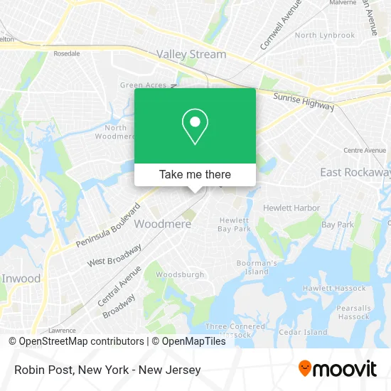
See Robin Post, Hewlett, on the map
Public Transit to Robin Post in Hewlett
Wondering how to get to Robin Post in Hewlett? Moovit helps you find the best way to get to Robin Post with step-by-step directions from the nearest public transit station.
Moovit provides free maps and live directions to help you navigate through your city. View schedules, routes, timetables, and find out how long does it take to get to Robin Post in real time.
Looking for the nearest stop or station to Robin Post? Check out this list of stops closest to your destination: Broadway + Franklin Ave; W Broadway + Franklin Ave; West Broadway Opp Mill Rd.; W Broadway / Mill; Cedarhurst; Valley Stream.
Bus: ELFX, N31, N31X/M, N32.Train: FAR ROCKAWAY BRANCH, BABYLON BRANCH, LONG BEACH BRANCH.
Want to see if there’s another route that gets you there at an earlier time? Moovit helps you find alternative routes or times. Get directions from and directions to Robin Post easily from the Moovit App or Website.
We make riding to Robin Post easy, which is why over 1.5 million users, including users in Hewlett, trust Moovit as the best app for public transit. You don’t need to download an individual bus app or train app, Moovit is your all-in-one transit app that helps you find the best bus time or train time available.
For information on prices of bus, train, light rail and subway, costs and ride fares to Robin Post, please check the Moovit app.
Use the app to navigate to popular places including to the airport, hospital, stadium, grocery store, mall, coffee shop, school, college, and university.
Robin Post Address: 1208 Broadway street in Hewlett
- Cargomatrix Inc.,
- Rozana & Sara Vip,
- Vladimir Reznikov,
- Leah and Alex Sajovits Team - at Douglas Elliman Real Estate,
- Avi's Auto Repair Collision,
- Karen M. Lish,
- United Coverage,
- Fresh Daily Drop,
- Reliable Home Appliance,
- Real Property Buyers,
- Bitcom Solutions,
- Dr. Karen Lish, Md,
- Wolf Phone Repairs,
- Cohen Psychological Services,
- Innovative Counseling and Assessment Of Nassau,
- Vinted Go Parcel Shop,
- Weight No More Diet Center,
- Mta Hewlett Station-Parking Lot,
- Alan Winder,
- Mt Your Mind
Places Near Robin Post (Hewlett)
- 1 Police Plaza, Manhattan,
- 911 Memorial, Manhattan,
- Pier 83, Manhattan,
- Times Square, Manhattan,
- Chinatown, Manhattan,
- Katz's Deli, Manhattan,
- 376 Hudson Street, Manhattan,
- 26 Federal Plaza, Manhattan,
- Queens Center Mall, Queens,
- qqqq, Manhattan,
- San Gennaro Feast, Manhattan,
- 66 John Street, Manhattan,
- Mountainside Hospital, Glen Ridge,
- Wall Street, Manhattan,
- Hudson Yards, Manhattan,
- SoHo, Manhattan,
- 3 Stone St, Manhattan,
- Bellevue Hospital, Manhattan,
- 111 Centre New York City Supreme Court, Manhattan,
- Rockefeller Center, Manhattan
How to get to popular places in New York - New Jersey with public transit
Get around Hewlett by public transit!
Traveling around Hewlett has never been so easy. See step by step directions as you travel to any attraction, street or major public transit station. View bus and train schedules, arrival times, service alerts and detailed routes on a map, so you know exactly how to get to anywhere in Hewlett.
When traveling to any destination around Hewlett use Moovit's Live Directions with Get Off Notifications to know exactly where and how far to walk, how long to wait for your line, and how many stops are left. Moovit will alert you when it's time to get off — no need to constantly re-check whether yours is the next stop.
Wondering how to use public transit in Hewlett or how to pay for public transit in Hewlett? Moovit public transit app can help you navigate your way with public transit easily, and at minimum cost. It includes public transit fees, ticket prices, and costs. Looking for a map of Hewlett public transit lines? Moovit public transit app shows all public transit maps in Hewlett with all Bus, Train, Subway, Light Rail, Ferry and Cable Car routes and stops on an interactive map.
New York - New Jersey has 6 transit type(s), including: Bus, Train, Subway, Light Rail, Ferry and Cable Car, operated by several transit agencies, including MTA Subway, Metro-North Railroad, LIRR, PATH, MTA New York City Transit - Express routes, MTA Bus, NJ Transit, NYC Ferry, NICE bus, Bee-Line Bus, NJ Transit Rail, Norwalk Transit District, Hartford Line, River Valley Transit and HART