How to get to Ropzap by bus?
Click on the bus route to see step by step directions with maps, line arrival times and updated time schedules.
From Universidad Europea de Madrid, Alcobendas
56 minFrom Matadero Madrid, Madrid
59 minFrom Calle Marroquina, Madrid
68 minFrom Cinesa Mendez Alvaro, Madrid
73 minFrom Hospital Sanitas La Zarzuela, Madrid
27 minFrom Conde De Peñalver, Madrid
50 minFrom Entrevías, Madrid
74 minFrom Calle Ulises, Madrid
39 minFrom Avenida de Nuestra Señora de Valvanera, Madrid
74 minFrom Calle de Almagro, Madrid
41 min
How to get to Ropzap by train?
Click on the train route to see step by step directions with maps, line arrival times and updated time schedules.
How to get to Ropzap by metro?
Click on the metro route to see step by step directions with maps, line arrival times and updated time schedules.
From Universidad Europea de Madrid, Alcobendas
55 minFrom Matadero Madrid, Madrid
53 minFrom Calle Marroquina, Madrid
44 minFrom Cinesa Mendez Alvaro, Madrid
49 minFrom Conde De Peñalver, Madrid
34 minFrom Entrevías, Madrid
49 minFrom Calle Ulises, Madrid
45 minFrom Avenida de Nuestra Señora de Valvanera, Madrid
44 minFrom Calle de Almagro, Madrid
32 min
Bus stops near Ropzap in Madrid
Bus lines to Ropzap in Madrid
What are the closest stations to Ropzap?
The closest stations to Ropzap are:
- Herrera Oria - Isla De Arosa is 1 meters away, 1 min walk.
- Herrera Oria - Gómez De La Serna is 158 meters away, 3 min walk.
- Isla De Arosa is 291 meters away, 4 min walk.
- Fermín Caballero - Isla De Arosa is 491 meters away, 7 min walk.
- Herrera Oria is 1109 meters away, 15 min walk.
- Peñagrande is 1490 meters away, 20 min walk.
Which bus lines stop near Ropzap?
These bus lines stop near Ropzap: 133, 134, 179, 815, 83.
Which train lines stop near Ropzap?
These train lines stop near Ropzap: C7, C8A.
Which metro lines stop near Ropzap?
These metro lines stop near Ropzap: M-7, M-9.
What’s the nearest metro station to Ropzap in Madrid?
The nearest metro station to Ropzap in Madrid is Herrera Oria. It’s a 15 min walk away.
What’s the nearest bus station to Ropzap in Madrid?
The nearest bus station to Ropzap in Madrid is Herrera Oria - Isla De Arosa. It’s a 1 min walk away.
What time is the first metro to Ropzap in Madrid?
The M-7 is the first metro that goes to Ropzap in Madrid. It stops nearby at 6:05 AM.
What time is the last metro to Ropzap in Madrid?
The M-9 is the last metro that goes to Ropzap in Madrid. It stops nearby at 2:12 AM.
What time is the first bus to Ropzap in Madrid?
The 127 is the first bus that goes to Ropzap in Madrid. It stops nearby at 7:05 AM.
What time is the last bus to Ropzap in Madrid?
The N21 is the last bus that goes to Ropzap in Madrid. It stops nearby at 3:36 AM.
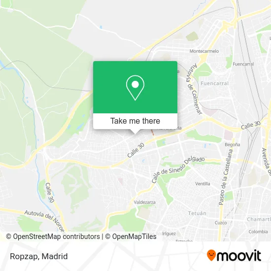
See Ropzap, Madrid, on the map
Public Transit to Ropzap in Madrid
Wondering how to get to Ropzap in Madrid? Moovit helps you find the best way to get to Ropzap with step-by-step directions from the nearest public transit station.
Moovit provides free maps and live directions to help you navigate through your city. View schedules, routes, timetables, and find out how long does it take to get to Ropzap in real time.
Looking for the nearest stop or station to Ropzap? Check out this list of stops closest to your destination: Herrera Oria - Isla De Arosa; Herrera Oria - Gómez De La Serna; Isla De Arosa; Fermín Caballero - Isla De Arosa; Herrera Oria; Peñagrande.
Bus: 133, 134, 179, 815, 83, 49, 67, N20, 64.Train: C7, C8A.Metro: M-7, M-9.
Want to see if there’s another route that gets you there at an earlier time? Moovit helps you find alternative routes or times. Get directions from and directions to Ropzap easily from the Moovit App or Website.
We make riding to Ropzap easy, which is why over 1.5 million users, including users in Madrid, trust Moovit as the best app for public transit. You don’t need to download an individual bus app or train app, Moovit is your all-in-one transit app that helps you find the best bus time or train time available.
For information on prices of metro, bus and train, costs and ride fares to Ropzap, please check the Moovit app.
Use the app to navigate to popular places including to the airport, hospital, stadium, grocery store, mall, coffee shop, school, college, and university.
Ropzap Address: Avenida del Cardenal Herrera Oria, 245 28035 Peñagrande Madrid street in Madrid
- Joyería Jobe,
- Mika Unas,
- Compro Oro y Plata,
- Jensy Flores,
- Panadería El Paso,
- Restaurante Kebabish,
- Emmanuel,
- Isla de Tavira 36,
- Francisco Javier López Busto,
- Peluquería Enmanuel Barber Shop,
- Josue Traverso,
- Peluqueria Rosa Garcia,
- Pomar Gls Parcelshop,
- Hospital de Ordenadores,
- Farmacia - Avenida Cardenal Herrera Oria 241,
- María Eugenia Romero Arco,
- Fernandez Lizarbe Jose Ramon,
- Modlis Conal S.L.,
- Pasteleria Herrera Ori,
- Madrid Suc 54
Places Near Ropzap (Madrid)
- Plaza Mayor, Madrid,
- Nassica, Área Metropolitana De Madrid Y Corredor Del Henares,
- Hospital Universitario Ramón y Cajal, Madrid,
- Mercadillo de Majadahonda, Majadahonda,
- Centro Comercial Oasiz Madrid, Área Metropolitana De Madrid Y Corredor Del Henares,
- Mendez Alvaro, Madrid,
- Hospital Clínico Universitario San Carlos, Madrid,
- Estadio Wanda Metropolitano, Área Metropolitana De Madrid Y Corredor Del Henares,
- Hospital Universitario La Paz, Madrid,
- Estacion de Chamartin, Madrid,
- Calle de López de Hoyos 169, Madrid,
- Sala La Riviera, Madrid,
- Plenilunio, Área Metropolitana De Madrid Y Corredor Del Henares,
- Centro Comercial La Gavia, Área Metropolitana De Madrid Y Corredor Del Henares,
- Tres Aguas, Alcorcón,
- Wizink Center, Madrid,
- Centro Comercial Islazul, Área Metropolitana De Madrid Y Corredor Del Henares,
- Rastro De Madrid, Área Metropolitana De Madrid Y Corredor Del Henares,
- Centro Comercial La Vaguada, Área Metropolitana De Madrid Y Corredor Del Henares,
- Palacio De Vistalegre, Área Metropolitana De Madrid Y Corredor Del Henares
How to get to popular places in Madrid with public transit
Get around Madrid by public transit!
Traveling around Madrid has never been so easy. See step by step directions as you travel to any attraction, street or major public transit station. View bus and train schedules, arrival times, service alerts and detailed routes on a map, so you know exactly how to get to anywhere in Madrid.
When traveling to any destination around Madrid use Moovit's Live Directions with Get Off Notifications to know exactly where and how far to walk, how long to wait for your line, and how many stops are left. Moovit will alert you when it's time to get off — no need to constantly re-check whether yours is the next stop.
Wondering how to use public transit in Madrid or how to pay for public transit in Madrid? Moovit public transit app can help you navigate your way with public transit easily, and at minimum cost. It includes public transit fees, ticket prices, and costs. Looking for a map of Madrid public transit lines? Moovit public transit app shows all public transit maps in Madrid with all Bus, Train, Metro and Light Rail routes and stops on an interactive map.
Madrid has 4 transit type(s), including: Bus, Train, Metro and Light Rail, operated by several transit agencies, including Metro de Madrid, Metro Ligero, Tranvía de Parla, Renfe Cercanías - Servicios de Autobús especiales, Renfe Cercanias, Renfe Cercanías, EMT, Interurbanos, Urbanos de Alcalá de Henares, Urbanos de Alcobendas, Urbanos de Alcorcón, Urbanos de Algete, Urbanos de Aranjuez, Urbanos de Arganda del Rey and Urbanos de Arroyomolinos