Rt-70 at Kohl's Shopping Center (Rt 73) stop - Thursday schedule
| Line | Direction | Time |
|---|---|---|
| 406 | Berln Twp | 6:26 AM |
| 406 | Marlton Via CH Hill Ind Pk | 6:29 AM |
| 406 | Berln Twp Via CH Hill Ind Pk | 7:26 AM |
| 406 | Berln Twp Via CH Hill Ind Pk | 8:33 AM |
| 406 | Marlton Via CH Hill Ind Pk | 8:53 AM |
| 406 | Marlton Via CH Hill Ind Pk | 9:13 AM |
| 406 | Berln Twp | 9:35 AM |
| 406 | Berln Twp | 10:32 AM |
| 406 | Marlton | 10:52 AM |
| 406 | Marlton | 12:13 PM |
| 406 | Marlton | 1:33 PM |
| 406 | Marlton | 2:49 PM |
| 406 | Marlton | 4:53 PM |
| 406 | Marlton | 5:23 PM |
| 406 | Marlton | 6:27 PM |
| 406 | Berln Twp | 6:55 PM |
| 406 | Berln Twp | 7:11 PM |
| 406 | Berln Twp | 8:06 PM |
| 406 | Marlton | 8:41 PM |
| 406 | Berln Twp | 9:40 PM |
| 406 | Berln Twp | 10:36 PM |
| 406 | Berln Twp | 11:36 PM |
Directions to Rt-70 at Kohl's Shopping Center (Rt 73) stop (Philadelphia) with public transit
The following transit lines have routes that pass near Rt-70 at Kohl's Shopping Center (Rt 73)
 Bus: 406.
How to get to Rt-70 at Kohl's Shopping Center (Rt 73) stop by bus?
Click on the bus route to see step by step directions with maps, line arrival times and updated time schedules.
Bus stops near Rt-70 at Kohl's Shopping Center (Rt 73) stop in Philadelphia
- Rt-70 at Kohl's Shopping Center (Rt 73), 2 min walk,
Bus lines to Rt-70 at Kohl's Shopping Center (Rt 73) stop in Philadelphia
- 406, Marlton,
What are the closest stations to Rt-70 at Kohl's Shopping Center (Rt 73)?
The closest stations to Rt-70 at Kohl's Shopping Center (Rt 73) are:
- Rt-70 at Kohl's Shopping Center (Rt 73) is 86 yards away, 2 min walk.
Which bus line stops near Rt-70 at Kohl's Shopping Center (Rt 73)?
406 (Berln Twp)
What’s the nearest bus station to Rt-70 at Kohl's Shopping Center (Rt 73) in Philadelphia?
The nearest bus station to Rt-70 at Kohl's Shopping Center (Rt 73) in Philadelphia is Rt-70 at Kohl's Shopping Center (Rt 73). It’s a 2 min walk away.
What time is the first bus to Rt-70 at Kohl's Shopping Center (Rt 73) in Philadelphia?
The 406 is the first bus that goes to Rt-70 at Kohl's Shopping Center (Rt 73) in Philadelphia. It stops nearby at 5:35 AM.
What time is the last bus to Rt-70 at Kohl's Shopping Center (Rt 73) in Philadelphia?
The 406 is the last bus that goes to Rt-70 at Kohl's Shopping Center (Rt 73) in Philadelphia. It stops nearby at 11:59 PM.
Rt-70 at Kohl's Shopping Center (Rt 73) station
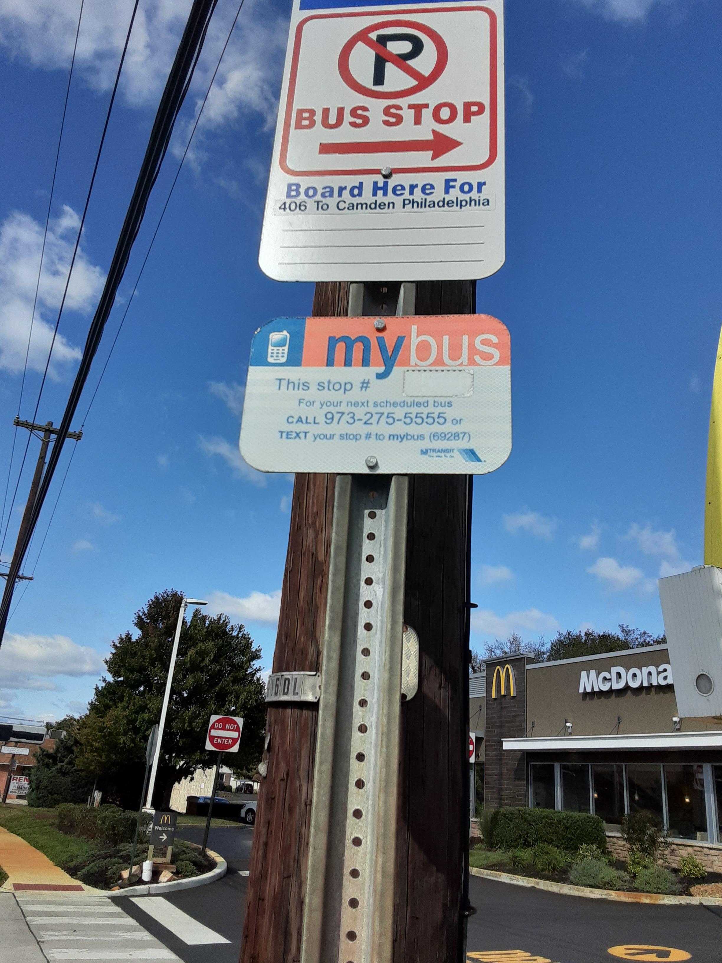 Taken by Anonymous
See Rt-70 at Kohl's Shopping Center (Rt 73) stop, Philadelphia, on the map
Public transit to Rt-70 at Kohl's Shopping Center (Rt 73) stop (ID: 32565) in Philadelphia
Looking for directions to Rt-70 at Kohl's Shopping Center (Rt 73) in Philadelphia, United States?
Download the Moovit App to find the current schedule and step-by-step directions for Bus or Metro routes that pass through Rt-70 at Kohl's Shopping Center (Rt 73).
Looking for the nearest stops closest to Rt-70 at Kohl's Shopping Center (Rt 73) ? Check out this list of closest stops to your destination: Rt-70 at Kohl's Shopping Center (Rt 73).
Bus: 406.
We make riding on public transit to Rt-70 at Kohl's Shopping Center (Rt 73) easy, which is why over 1.5 million users, including users in Philadelphia trust Moovit as the best app for public transit.
Use the app to navigate to popular places including to the airport, hospital, stadium, grocery store, mall, coffee shop, school, college, and university.
Rt-70 at Kohl's Shopping Center (Rt 73) stop’s code is 32565
The first line to this stop is 406, at 6:26 AM, and the last line is 406 at 11:36 PM.
This stop serves NJ Transit Bus’s lines
- Rt-70 at Kohl's Shopping Center (Rt 73)
Bus stop near Rt-70 at Kohl's Shopping Center (Rt 73) stop
- Broad St & Vine St,
- Haddonfield Patco,
- 10th St & Duncannon Av,
- White Horse Pike at Washington Ave,
- Academy Rd & Woodhaven Rd,
- 19th St & Chestnut St - Fs,
- Elmwood Av & 73rd St,
- Nj State Police Headquarters,
- 12th St & Wallace St ,
- 40th-Market,
- Verree Rd & Bloomfield Av,
- Elmwood Av & 61st St,
- Leverington St & Main St,
- Oxford Valley Rd & Trenton Rd,
- 60th St & Market St,
- 11th St & Poplar St,
- Harbison Av & Comly St ,
- Market St at N 6th St,
- Bethlehem Pk & Stenton Av ,
- Marshall Rd & Church Ln
Popular public transit stations in Philadelphia
Get around Philadelphia by public transit!
Traveling around Philadelphia has never been so easy. See step by step directions as you travel to any attraction, street or major public transit station. View bus and train schedules, arrival times, service alerts and detailed routes on a map, so you know exactly how to get to anywhere in Philadelphia.
When traveling to any destination around Philadelphia use Moovit's Live Directions with Get Off Notifications to know exactly where and how far to walk, how long to wait for your line, and how many stops are left. Moovit will alert you when it's time to get off — no need to constantly re-check whether yours is the next stop.
Wondering how to use public transit in Philadelphia or how to pay for public transit in Philadelphia? Moovit public transit app can help you navigate your way with public transit easily, and at minimum cost. It includes public transit fees, ticket prices, and costs. Looking for a map of Philadelphia public transit lines? Moovit public transit app shows all public transit maps in Philadelphia with all Bus, Train, Metro, Light Rail and Cable Car routes and stops on an interactive map.
Philadelphia has 5 transit type(s), including: Bus, Train, Metro, Light Rail and Cable Car, operated by several transit agencies, including SEPTA Subway, SEPTA Rail, SEPTA, SEPTA Trolley, NJ Transit Rail, NJ Transit Bus, Port Authority Transit Corporation, Navy Yard, Penn Transit, Drexel University, Pottstown Area Rapid Transit (PART), Fullington Tours, Chescobus, Amtrak and Greyhound-us