How to get to Rue de Hausquette by bus?
Click on the bus route to see step by step directions with maps, line arrival times and updated time schedules.
How to get to Rue de Hausquette by train?
Click on the train route to see step by step directions with maps, line arrival times and updated time schedules.
From Parkplatz Bauhaus, Verwaltungsgemeinschaft Offenburg
81 minFrom Stadtwerke Villingen-Schwenningen GmbH, Villingen-Schwenningen
117 minFrom Klinik Hohenfreudenstadt, Vereinbarte Verwaltungsgemeinschaft Freudenstadt
209 minFrom Hotel Palmenwald, Vereinbarte Verwaltungsgemeinschaft Freudenstadt
172 minFrom Lotto-Annahmestelle, Schopfheim
122 minFrom Krankenhaus Freudenstadt, Vereinbarte Verwaltungsgemeinschaft Freudenstadt
202 min
Light Rail stations near Rue de Hausquette in Stuttgart
Bus stops near Rue de Hausquette in Stuttgart
Bus lines to Rue de Hausquette in Stuttgart
- 1, Freiburg, Moosweiher Bstg 2 - Freiburg, Laßbergstraße Bstg 1,VIEW
- 17, Freiburg, Laßbergstraße Bstg 4 - Freiburg, Molzhofsiedlung,VIEW
- 18, Freiburg, Langmatten - Freiburg, Laßbergstraße Bstg 4,VIEW
- 221, Himmelreich Bahnhof - Wagensteig Löwen,VIEW
- 27, Freiburg, Europaplatz Bstg 4 - Freiburg, Richard-Strauss-Str.,VIEW
- 37, Munzingen, Windhäuslegasse - Freiburg Hauptbahnhof Bstg 4,VIEW
- 7216, Freiburg Hauptbahnhof Bstg 11 - Kirchzarten Bahnhof Bstg 1,VIEW
- 7216, Freiburg Hauptbahnhof Bstg 11 - St. Peter Zähringer Eck,VIEW
- 11, Freiburg Hauptbahnhof Bstg 14 - Freiburg, Munzinger Straße Bstg 12,VIEW
- 21, Freiburg, Dorfstraße Bstg 4 - Freiburg, Schauinslandbahn Talstation,VIEW
- 7208, Bad Krozingen Bahnhof Bstg 1 - Freiburg Hauptbahnhof Bstg 11,VIEW
- 7240, Staufen (Brsg) Bahnhof - Freiburg Hauptbahnhof Bstg 11,VIEW
- 7240, Freiburg Hauptbahnhof Bstg 9 - Bad Krozingen Bahnhof Bstg 4,VIEW
- 7240, Bad Krozingen Bahnhof Bstg 1 - Freiburg Hauptbahnhof Bstg 11,VIEW
- N40, Freiburg Hauptbahnhof Bstg 14 - Munzingen, Windhäuslegasse,VIEW
- 23, Freiburg, Munzinger Straße,VIEW
- 7240, Bad Krozingen Schulzentrum,VIEW
What are the closest stations to Rue de Hausquette?
The closest stations to Rue de Hausquette are:
- Freiburg, Lorettostraße is 66 meters away, 2 min walk.
- Freiburg, Mattenstraße is 105 meters away, 2 min walk.
- Freiburg, Johanneskirche Bstg 1 is 383 meters away, 6 min walk.
- Freiburg, Schwabentorbrücke is 399 meters away, 6 min walk.
- Freiburg, Rehlingstraße is 572 meters away, 8 min walk.
Which bus lines stop near Rue de Hausquette?
These bus lines stop near Rue de Hausquette: 200, 271.
Which train lines stop near Rue de Hausquette?
These train lines stop near Rue de Hausquette: RE 7, RE7, S10.
Which light rail line stops near Rue de Hausquette?
2 (Freiburg, Dorfstraße)
What’s the nearest light rail station to Rue de Hausquette in Stuttgart?
The nearest light rail stations to Rue de Hausquette in Stuttgart are Freiburg, Lorettostraße and Freiburg, Mattenstraße. The closest one is a 2 min walk away.
What’s the nearest bus station to Rue de Hausquette in Stuttgart?
The nearest bus station to Rue de Hausquette in Stuttgart is Freiburg, Schwabentorbrücke. It’s a 6 min walk away.
What time is the first light rail to Rue de Hausquette in Stuttgart?
The 5 is the first light rail that goes to Rue de Hausquette in Stuttgart. It stops nearby at 5:02 AM.
What time is the last light rail to Rue de Hausquette in Stuttgart?
The 5 is the last light rail that goes to Rue de Hausquette in Stuttgart. It stops nearby at 1:07 AM.
What time is the first bus to Rue de Hausquette in Stuttgart?
The 17 is the first bus that goes to Rue de Hausquette in Stuttgart. It stops nearby at 4:59 AM.
What time is the last bus to Rue de Hausquette in Stuttgart?
The 17 is the last bus that goes to Rue de Hausquette in Stuttgart. It stops nearby at 1:29 AM.
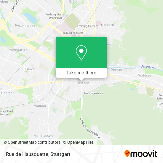
See Rue de Hausquette, Stuttgart, on the map
Public Transit to Rue de Hausquette in Stuttgart
Wondering how to get to Rue de Hausquette in Stuttgart? Moovit helps you find the best way to get to Rue de Hausquette with step-by-step directions from the nearest public transit station.
Moovit provides free maps and live directions to help you navigate through your city. View schedules, routes, timetables, and find out how long does it take to get to Rue de Hausquette in real time.
Looking for the nearest stop or station to Rue de Hausquette? Check out this list of stops closest to your destination: Freiburg; Freiburg; Freiburg; Freiburg; Freiburg.
Bus: 200, 271, 1, 17, 18, 221, 27, 11, 21, 7208, 7240, 7240, 23, 7240.Train: RE 7, RE7, S10.Light Rail: 2.
Want to see if there’s another route that gets you there at an earlier time? Moovit helps you find alternative routes or times. Get directions from and directions to Rue de Hausquette easily from the Moovit App or Website.
We make riding to Rue de Hausquette easy, which is why over 1.5 million users, including users in Stuttgart, trust Moovit as the best app for public transit. You don’t need to download an individual bus app or train app, Moovit is your all-in-one transit app that helps you find the best bus time or train time available.
For information on prices of train, bus and light rail, costs and ride fares to Rue de Hausquette, please check the Moovit app.
Use the app to navigate to popular places including to the airport, hospital, stadium, grocery store, mall, coffee shop, school, college, and university.
Rue de Hausquette Address: Günterstalstraße 43 Wiehre, 79102 Freiburg im Breisgau street in Stuttgart
- Dr. Stange & Co. Nachf.,
- Fliegauf Wohnbau,
- Dr. Stange Immobilien Freiburg,
- ALDI Süd,
- Hausmeisterservice Beutler,
- Bildung und Leben Baden-Württemberg,
- Psychosoziale Beratungsstelle,
- Artjamming,
- Der Deutsches Reisebüro,
- Eiscafé Amore,
- Glow Freiburg,
- Hotel/Restaurant der Kaiser,
- Robert Grumbach,
- Berta Grumbach,
- Energie Sparen Freiburg de,
- Von Poll Immobilien Freiburg,
- Rottnick Schnellreinigung,
- Argo Personal Service,
- Steuerberatung Freiburg,
- Schröder Wolfgang
Places Near Rue de Hausquette (Stuttgart)
- Hauptbahnhof Stuttgart, Stuttgart-Mitte,
- Waldfriedhof, Degerloch,
- Wilhelma (U-Bahn Wilhelma), Bad Cannstatt,
- Schleyerhalle, Bad Cannstatt,
- Mettingen Eros-Center Puff Laufhaus, Esslingen Am Neckar,
- Pariser Platz Stuttgart, Stuttgart-Mitte,
- Hanns-Martin-Schleyer-Halle (Stuttgart Hans-Martin-Schleyerhalle), Bad Cannstatt,
- Porsche-Arena, Bad Cannstatt,
- Gleis 101/102 (tief), Stuttgart-Mitte,
- Gasometer Pforzheim, Pforzheim,
- Porsche Museum, Zuffenhausen,
- Mercedes-Benz Museum (Mercedes Museum Stuttgart), Bad Cannstatt,
- Mercedes-Benz Museum, Bad Cannstatt,
- Geilhaus Haus 33a, Reutlingen-Betzingen,
- Im Wizemann (Halle), Bad Cannstatt,
- FlixBus Haltestelle, Stuttgart,
- Klinikum Stuttgart - Katharinenhospital, Stuttgart-Mitte,
- Hanns-Martin-Schleyer-Halle, Bad Cannstatt,
- SI-Centrum, Möhringen,
- Marmorsaal Im Weissenburgpark, Stuttgart-Süd
How to get to popular places in Stuttgart with public transit
Get around Stuttgart by public transit!
Traveling around Stuttgart has never been so easy. See step by step directions as you travel to any attraction, street or major public transit station. View bus and train schedules, arrival times, service alerts and detailed routes on a map, so you know exactly how to get to anywhere in Stuttgart.
When traveling to any destination around Stuttgart use Moovit's Live Directions with Get Off Notifications to know exactly where and how far to walk, how long to wait for your line, and how many stops are left. Moovit will alert you when it's time to get off — no need to constantly re-check whether yours is the next stop.
Wondering how to use public transit in Stuttgart or how to pay for public transit in Stuttgart? Moovit public transit app can help you navigate your way with public transit easily, and at minimum cost. It includes public transit fees, ticket prices, and costs. Looking for a map of Stuttgart public transit lines? Moovit public transit app shows all public transit maps in Stuttgart with all Bus, Train, Subway, Light Rail, Ferry, S-Bahn and Funicular routes and stops on an interactive map.
Stuttgart has 7 transit type(s), including: Bus, Train, Subway, Light Rail, Ferry, S-Bahn and Funicular, operated by several transit agencies, including SSB - Stadtbahn, SSB, SSB - Seilbahn / Zacke, S-Bahn Stuttgart, Rhein-Neckar-Verkehr GmbH (rnv), Karlsruher Verkehrsverbund, DB AG, DB Regiobus BW, Arverio Baden-Württemberg GmbH, DB RegioNetz Verkehrs GmbH Westfrankenbahn, DB Regio AG Baden-Württemberg, Südwestdeutsche Verkehrs-AG, DB Regio AG Mitte Region Hessen, DB and Bodensee-Oberschwaben-Bahn
Public transit lines with stations closest to Rue de Hausquette in Stuttgart
Bus lines with stations closest to Rue de Hausquette in Stuttgart
Freiburg, Rehlingstraße
 11Freiburg Hauptbahnhof Bstg 14 - Freiburg, Munzinger Straße Bstg 12
- 21Freiburg, Dorfstraße Bstg 4 - Freiburg, Schauinslandbahn Talstation
- 7208Bad Krozingen Bahnhof Bstg 1 - Freiburg Hauptbahnhof Bstg 11
- 7240Staufen (Brsg) Bahnhof - Freiburg Hauptbahnhof Bstg 11
- 7240Freiburg Hauptbahnhof Bstg 9 - Bad Krozingen Bahnhof Bstg 4