San Andres Pnr station - Monday schedule
| Line | Direction | Time |
|---|---|---|
| MRT3 | North Avenue | 5:32 AM |
| MRT3 | North Avenue | 6:02 AM |
| MRT3 | North Avenue | 6:32 AM |
| MRT3 | North Avenue | 7:02 AM |
| MRT3 | Taft Avenue | 7:16 AM |
| MRT3 | North Avenue | 7:32 AM |
| MRT3 | Taft Avenue | 7:46 AM |
| MRT3 | North Avenue | 8:02 AM |
| MRT3 | Taft Avenue | 8:16 AM |
| MRT3 | North Avenue | 8:32 AM |
| MRT3 | Taft Avenue | 8:46 AM |
| MRT3 | North Avenue | 9:02 AM |
| MRT3 | Taft Avenue | 9:16 AM |
| MRT3 | North Avenue | 9:32 AM |
| MRT3 | Taft Avenue | 9:46 AM |
| MRT3 | North Avenue | 10:02 AM |
| MRT3 | Taft Avenue | 10:16 AM |
| MRT3 | North Avenue | 10:32 AM |
| MRT3 | Taft Avenue | 10:46 AM |
| MRT3 | North Avenue | 11:02 AM |
| MRT3 | Taft Avenue | 11:16 AM |
| MRT3 | North Avenue | 11:32 AM |
| MRT3 | Taft Avenue | 11:46 AM |
| MRT3 | North Avenue | 12:02 PM |
| MRT3 | Taft Avenue | 12:16 PM |
Directions to San Andres Pnr station (Manila) with public transit
The following transit lines have routes that pass near San Andres Pnr
 Bus: BUS, JEEP, UV, UV.
- Train: PNR MC, LRT 1.
How to get to San Andres Pnr station by bus?
Click on the bus route to see step by step directions with maps, line arrival times and updated time schedules.
How to get to San Andres Pnr station by train?
Click on the train route to see step by step directions with maps, line arrival times and updated time schedules.
Bus stops near San Andres Pnr stop in Manila
- Pablo Ocampo Sr. / G.Del Pilar, Manila, 2 min walk,
- Pnr Vito Cruz Station, South Luzon Expressway, Makati City, Manila, 4 min walk,
- Pedro Gil / Fabie Intersection, Manila, 4 min walk,
- Vito Cruz, 5 min walk,
- President Quirino Ave, Manila, 6 min walk,
- Agusto Francisco, Manila, 7 min walk,
Train stations near San Andres Pnr station in Manila
- Paco Pnr, 6 min walk,
- Quirino Ave Lrt, 20 min walk,
Bus lines to San Andres Pnr station in Manila
- JEEP, Taft Avenue / Pablo Ocampo Sreet, Avenue, Manila,
- UV, Vito Cruz,
- UV, Sm Fairview,
- BUS, Andres Soriano Jr Ave / Muralla Intersection, Manila,
- BUS, South Luzon Expressway / Montillano St Intersection, Muntinlupa City, Manila,
- BUS, Quezon Blvd, Manila,
- BUS, Makati Ave / Ayala Avenue Intersection, Makati City, Manila,
- JEEP, Sta Ana P Faura,
- JEEP, L GUINTO - MAKATI via SAN ANDRES,
- JEEP, Guadalupe Mkt. - L. Guinto via P. Gil,
- JEEP, San Andres Mkt. - Sta. Ana via P. Faura, P. Gil,
- JEEP, L GUINTO - STA ANA,
- JEEP, Padre Faura - Sta Ana,
- JEEP, Angel Linao / Pedro Gil,
- JEEP, MAKATI P BURGOS - L GUINTO,
- JEEP, Pfaura San Andres via M Adriatico,
- JEEP, P. Faura - San Andres,
- JEEP, San Andres via P Faura,
What are the closest stations to San Andres Pnr?
The closest stations to San Andres Pnr are:
- Pablo Ocampo Sr. / G.Del Pilar, Manila is 113 meters away, 2 min walk.
- Vito Cruz is 236 meters away, 5 min walk.
- Pnr Vito Cruz Station, South Luzon Expressway, Makati City, Manila is 236 meters away, 4 min walk.
- Pedro Gil / Fabie Intersection, Manila is 300 meters away, 4 min walk.
- President Quirino Ave, Manila is 420 meters away, 6 min walk.
- Paco Pnr is 420 meters away, 6 min walk.
- Agusto Francisco, Manila is 489 meters away, 7 min walk.
- Quirino Ave Lrt is 1515 meters away, 20 min walk.
Which bus lines stop near San Andres Pnr?
These bus lines stop near San Andres Pnr: BUS, JEEP.
Which train line stops near San Andres Pnr?
PNR MC (Biñan PNR)
What’s the nearest train station to San Andres Pnr in Manila?
The nearest train station to San Andres Pnr in Manila is Paco Pnr. It’s a 6 min walk away.
What’s the nearest bus station to San Andres Pnr in Manila?
The nearest bus station to San Andres Pnr in Manila is Pablo Ocampo Sr. / G.Del Pilar, Manila. It’s a 2 min walk away.
What time is the first train to San Andres Pnr in Manila?
The LRT 1 is the first train that goes to San Andres Pnr in Manila. It stops nearby at 5:09 AM.
What time is the last train to San Andres Pnr in Manila?
The PNR MC is the last train that goes to San Andres Pnr in Manila. It stops nearby at 1:19 AM.
What time is the first bus to San Andres Pnr in Manila?
The BUS is the first bus that goes to San Andres Pnr in Manila. It stops nearby at 3:07 AM.
What time is the last bus to San Andres Pnr in Manila?
The BUS is the last bus that goes to San Andres Pnr in Manila. It stops nearby at 3:13 AM.
See San Andres Pnr station, Manila, on the map
Public transit to San Andres Pnr station in Manila
Looking for directions to San Andres Pnr in Manila, Philippines?
Download the Moovit App to find the current schedule and step-by-step directions for Bus or Train routes that pass through San Andres Pnr.
Looking for the nearest stops closest to San Andres Pnr ? Check out this list of closest stops to your destination: Pablo Ocampo Sr. / G.Del Pilar; Vito Cruz; Pnr Vito Cruz Station; Pedro Gil / Fabie Intersection; President Quirino Ave; Paco Pnr; Agusto Francisco; Quirino Ave Lrt.
Bus: BUS, JEEP, UV, UV.Train: PNR MC, LRT 1.
We make riding on public transit to San Andres Pnr easy, which is why over 1.5 million users, including users in Manila trust Moovit as the best app for public transit.
Use the app to navigate to popular places including to the airport, hospital, stadium, grocery store, mall, coffee shop, school, college, and university.
The station has the following entrances: Pnr San Andres Station
The first line to this station is MRT3, at 5:32 AM, and the last line is MRT3 at 1:16 AM.
Diamante, Philippines
This station serves MRTC’s lines
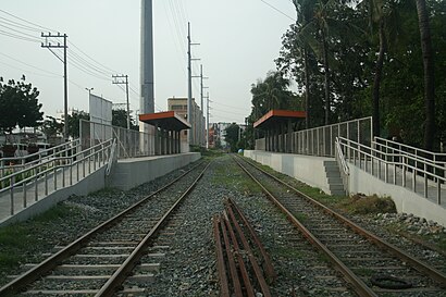
San Andres station is a railway station located on the South Main Line in the city of Manila, Philippines. San Andres station is the seventh station southbound from Tutuban.Wiki
- Pablo Ocampo Sr. / G.Del Pilar, Manila,
- Pnr Vito Cruz Station, South Luzon Expressway, Makati City, Manila,
- Pedro Gil / Fabie Intersection, Manila,
- Vito Cruz,
- President Quirino Ave, Manila,
- Agusto Francisco, Manila
Bus stops near San Andres Pnr stop
- Paco Pnr,
- Quirino Ave Lrt
Train stations near San Andres Pnr station
- On Semiconductor, Governor's Dr, Carmona, Manila,
- Elpidio Santos, Pasig City, Manila,
- Diosdado Macapagal Blvd, Lungsod Ng Pasay, Manila,
- Paso De Blas, Valenzuela City,
- P.Zamora, Lungsod Ng Pasay,
- Quezon Avenue, Quezon City,
- Teofilo Samson Road, Caloocan City,
- Roxas Blvd / Redemptorist Road Intersection, Parañaque City, Manila,
- Paso De Blas / P. Santiago Intersection, Valenzuela City,
- Polo National High School, Palassan Road, Valenzuela City,
- Domingo M Guevara, Mandaluyong City,
- 5th Ave West / A Del Mundo St, Caloocan City, Manila,
- Malabon City / Victoneta Avenue Intersection, Malabon City,
- North Luzon Expressway, Caloocan City,
- Starmall San Jose De Monte, Quirino Highway, City Of San Jose Del Monte,
- Bahay Pare Road, City Of Meycauayan,
- Light Rail Transit Line / Bulacan Intersection, Quezon City,
- E Dela Paz St, Marikina City, Manila,
- 20th Ave / Bayanin Rd, Quezon City, Manila,
- Scout Tobias / Timog Ave Intersection, Quezon City, Manila
Popular public transit stations in Manila
Get around Manila by public transit!
Traveling around Manila has never been so easy. See step by step directions as you travel to any attraction, street or major public transit station. View bus and train schedules, arrival times, service alerts and detailed routes on a map, so you know exactly how to get to anywhere in Manila.
When traveling to any destination around Manila use Moovit's Live Directions with Get Off Notifications to know exactly where and how far to walk, how long to wait for your line, and how many stops are left. Moovit will alert you when it's time to get off — no need to constantly re-check whether yours is the next stop.
Wondering how to use public transit in Manila or how to pay for public transit in Manila? Moovit public transit app can help you navigate your way with public transit easily, and at minimum cost. It includes public transit fees, ticket prices, and costs. Looking for a map of Manila public transit lines? Moovit public transit app shows all public transit maps in Manila with all Bus and Train routes and stops on an interactive map.
Manila has 2 transit type(s), including: Bus and Train, operated by several transit agencies, including MRTC, LRTA, PNR, LTFRB, BGC Bus, P2P and UV Express