San Lorenzo Station/Talamo - Wednesday schedule
| Line | Direction | Time |
|---|---|---|
| 2 | Mancini | 4:35 AM |
| 2 | Flaminio | 4:44 AM |
| 2 | Mancini | 4:47 AM |
| 3 | Valle Giulia | 4:58 AM |
| 2 | Mancini | 4:58 AM |
| 19L | Valle Giulia | 5:14 AM |
| 3 | Valle Giulia | 5:14 AM |
| 19L | Valle Giulia | 5:22 AM |
| 3 | Valle Giulia | 5:30 AM |
| 19L | Valle Giulia | 5:35 AM |
| 3 | Valle Giulia | 5:47 AM |
| 19L | Valle Giulia | 5:48 AM |
| 2 | Mancini | 5:55 AM |
| 19L | Valle Giulia | 6:01 AM |
| 3 | Valle Giulia | 6:04 AM |
| 19L | Valle Giulia | 6:15 AM |
| 3 | Valle Giulia | 6:21 AM |
| 3 | Valle Giulia | 6:29 AM |
| 19L | Valle Giulia | 6:29 AM |
| 3 | Valle Giulia | 6:36 AM |
| 19L | Valle Giulia | 6:41 AM |
| 3 | Valle Giulia | 6:51 AM |
| 19L | Valle Giulia | 6:53 AM |
| 19L | Valle Giulia | 7:05 AM |
| 3 | Valle Giulia | 7:06 AM |
Directions to San Lorenzo Station/Talamo (Roma) with public transportation
The following transit lines have routes that pass near San Lorenzo Station/Talamo
 Bus: 514, 71, N3D, A01, 5BUS.
- Train: FL5, R.
- Metro: A.
- Light Rail: 19L, 3.
How to get to San Lorenzo Station/Talamo by bus?
Click on the bus route to see step by step directions with maps, line arrival times and updated time schedules.
How to get to San Lorenzo Station/Talamo by train?
Click on the train route to see step by step directions with maps, line arrival times and updated time schedules.
How to get to San Lorenzo Station/Talamo by metro?
Click on the metro route to see step by step directions with maps, line arrival times and updated time schedules.
Light Rail stations near San Lorenzo Station/Talamo in Roma
- San Lorenzo Station/Talamo, 1 min walk,
Bus stops near San Lorenzo Station/Talamo in Roma
- San Lorenzo Station/Talamo, 1 min walk,
- Piazza Di Porta Maggiore, 5 min walk,
- San Lorenzo Station/Ausoni, 5 min walk,
- Piazzale Labicano, 5 min walk,
- Casilina/Labicano Square, 7 min walk,
Bus lines to San Lorenzo Station/Talamo in Roma
- N3D, Piazzale Ostiense-Piramide (Metro B-Rail Line),
- A01, Termini (Metro A-Metro B-Railway),
- 5BUS, Gerani,
- N5, Piazza Venezia,
- N11, Grotte Celoni,
- 14BUS, Togliatti/Molfetta,
- 105, Parco Di Centocelle (Mc),
- 150F, Villa Borghese/Washington,
- N543, Vertunni,
- N3S, Ostiense Square-Pyramid (Metro-Rail),
- 8BUS, Gianicolense/Casaletto,
- 514, Largo Preneste,
- A10, Togliatti/Prenestina,
- COTRAL, Rome | Termini Station (Cinquecento Square),
- COTRAL, Rome Termini Station (Giolitti),
What are the closest stations to San Lorenzo Station/Talamo?
The closest stations to San Lorenzo Station/Talamo are:
- San Lorenzo Station/Talamo is 27 meters away, 1 min walk.
- Piazza Di Porta Maggiore stop is 359 meters away, 5 min walk.
- San Lorenzo Station/Ausoni is 359 meters away, 5 min walk.
- Piazzale Labicano stop is 381 meters away, 5 min walk.
- Casilina/Labicano Square stop is 482 meters away, 7 min walk.
Which bus lines stop near San Lorenzo Station/Talamo?
These bus lines stop near San Lorenzo Station/Talamo: 514, 71.
Which train lines stop near San Lorenzo Station/Talamo?
These train lines stop near San Lorenzo Station/Talamo: FL5, R.
Which metro line stops near San Lorenzo Station/Talamo?
A (Anagnina)
Which light rail lines stop near San Lorenzo Station/Talamo?
These light rail lines stop near San Lorenzo Station/Talamo: 19L, 3.
What’s the nearest light rail station to San Lorenzo Station/Talamo in Roma?
The nearest light rail station to San Lorenzo Station/Talamo in Roma is San Lorenzo Station/Talamo. It’s a 1 min walk away.
What’s the nearest bus station to San Lorenzo Station/Talamo in Roma?
The nearest bus station to San Lorenzo Station/Talamo in Roma is San Lorenzo Station/Talamo. It’s a 1 min walk away.
What time is the first light rail to San Lorenzo Station/Talamo in Roma?
The 2 is the first light rail that goes to San Lorenzo Station/Talamo in Roma. It stops nearby at 4:35 AM.
What time is the last light rail to San Lorenzo Station/Talamo in Roma?
The 3 is the last light rail that goes to San Lorenzo Station/Talamo in Roma. It stops nearby at 2:05 AM.
What time is the first bus to San Lorenzo Station/Talamo in Roma?
The N11 is the first bus that goes to San Lorenzo Station/Talamo in Roma. It stops nearby at 3:02 AM.
What time is the last bus to San Lorenzo Station/Talamo in Roma?
The N11 is the last bus that goes to San Lorenzo Station/Talamo in Roma. It stops nearby at 3:42 AM.
San Lorenzo Station/Talamo
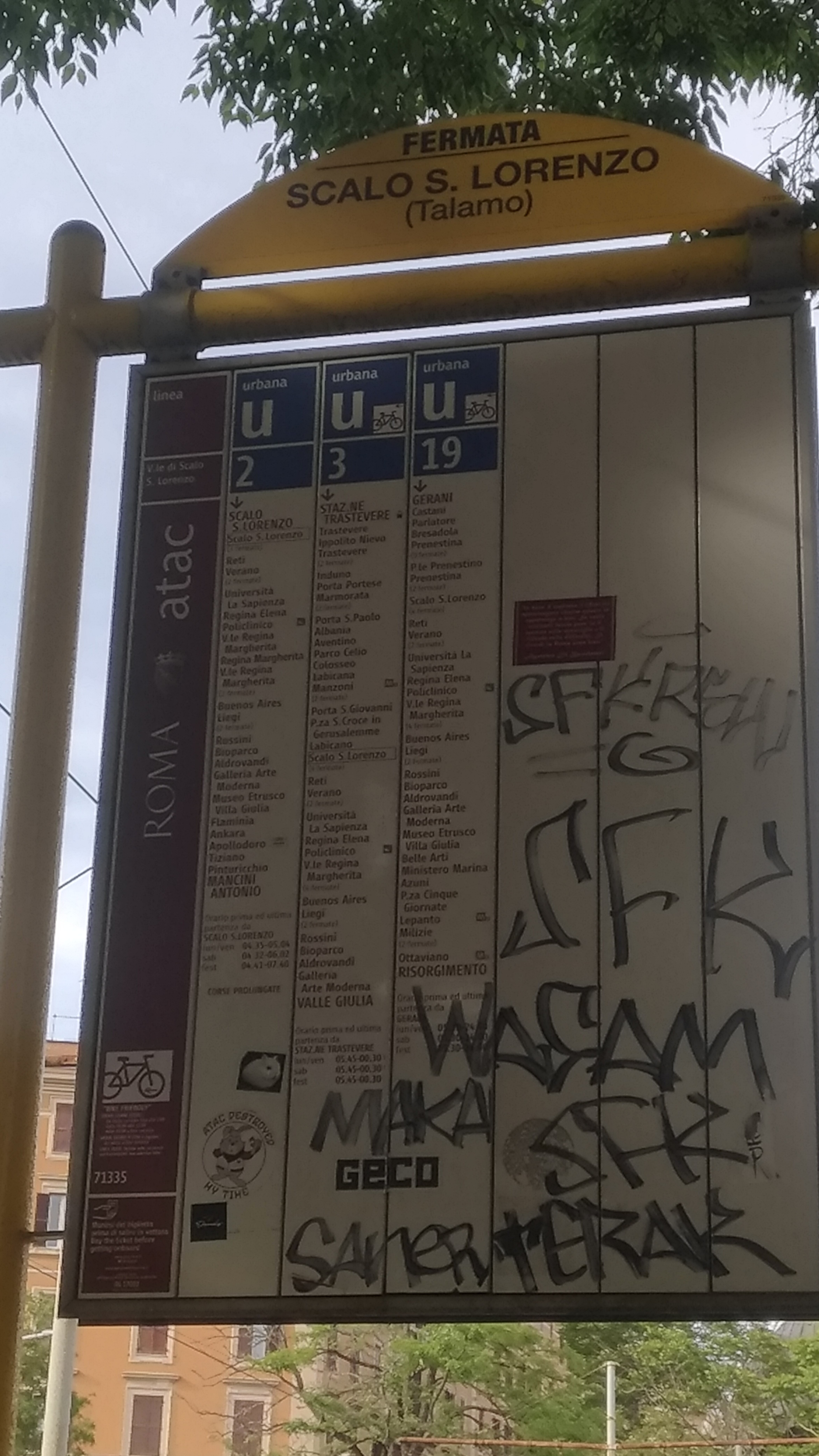 Taken by Simone P.
See San Lorenzo Station/Talamo, Roma, on the map
Public transit to San Lorenzo Station/Talamo (ID: 71335) in Roma
Looking for directions to San Lorenzo Station/Talamo in Roma, Italy?
Download the Moovit App to find the current schedule and step-by-step directions for Bus, Light Rail, Metro or Train routes that pass through San Lorenzo Station/Talamo.
Looking for the nearest stops closest to San Lorenzo Station/Talamo ? Check out this list of closest stops to your destination: San Lorenzo Station/Talamo; Piazza Di Porta Maggiore; San Lorenzo Station/Ausoni; Piazzale Labicano; Casilina/Labicano Square.
Bus: 514, 71, N3D, A01, 5BUS, N5, N11, 14BUS, N3S, 8BUS, A10.Train: FL5, R.Metro: A.Light Rail: 19L, 3.
We make riding on public transit to San Lorenzo Station/Talamo easy, which is why over 1.7 billion users, including users in Roma trust Moovit as the best app for public transit.
Use the app to navigate to popular places including to the airport, hospital, stadium, grocery store, mall, coffee shop, school, college, and university.
San Lorenzo Station/Talamo’s code is 71335
The first line to this station is 2, at 4:35 AM, and the last line is 3 at 1:06 AM.
Viale dello Scalo San Lorenzo, Roma, Italy
This station serves ATAC’s lines
- San Lorenzo Station/Talamo
Light Rail station near San Lorenzo Station/Talamo
- San Lorenzo Station/Talamo,
- Piazza Di Porta Maggiore,
- San Lorenzo Station/Ausoni,
- Piazzale Labicano,
- Casilina/Labicano Square
Bus stops near San Lorenzo Station/Talamo
- Costamagna,
- Gioacchino Belli,
- Casal Selce/Pantan Monastero,
- Arnara New Gate Square,
- Plebiscite Square,
- Colli Portuensi/Monteverde,
- Ladispoli, Falcone Square,
- Campo Boario,
- Portuense/Forlanini (H),
- Subiaco Hospital,
- Conservatory,
- Parioli/Stuparich,
- Cerchi/Porta Capena,
- Antonelli/Ponzi,
- Terracina | Appia Street (Km 108),
- Prenestina/Acqua Bullicante,
- Monte Del Gallo (Station),
- Prati Fiscali/Val D'Ala,
- Val Di Lanzo,
- Alessandro Magno/Casal Palocco
Popular public transit stations in Roma
Get around Roma by public transit!
Traveling around Roma has never been so easy. See step by step directions as you travel to any attraction, street or major public transit station. View bus and train schedules, arrival times, service alerts and detailed routes on a map, so you know exactly how to get to anywhere in Roma.
When traveling to any destination around Roma use Moovit's Live Directions with Get Off Notifications to know exactly where and how far to walk, how long to wait for your line, and how many stops are left. Moovit will alert you when it's time to get off — no need to constantly re-check whether yours is the next stop.
Wondering how to use public transit in Roma or how to pay for public transit in Roma? Moovit public transit app can help you navigate your way with public transit easily, and at minimum cost. It includes public transit fees, ticket prices, and costs. Looking for a map of Roma public transit lines? Moovit public transit app shows all public transit maps in Roma with all Bus, Train, Metro, Light Rail, Ferry, Funicular and Gondola routes and stops on an interactive map.
Rome and Lazio has 7 transit type(s), including: Bus, Train, Metro, Light Rail, Ferry, Funicular and Gondola, operated by several transit agencies, including ATAC, Cotral, Trenitalia, Troiani Transportation Services, BIS, ATR Mobility, Tuscia, Shuttle, Seatour, Troiani Bus Lines, CSC Mobility, Terravision, ATRAL, Tambus and Sitbus