How to get to Scs Informatique by bus?
Click on the bus route to see step by step directions with maps, line arrival times and updated time schedules.
From Clamart, Clamart
82 minFrom Hôpital Foch, Arrondissement de Nanterre
75 minFrom Hippodrome de Longchamp, Paris
78 minFrom Orange Gardens, Chatillon
83 minFrom Hopital Foch, Suresnes
75 minFrom Boulogne-Billancourt, Boulogne-Billancourt
92 minFrom Bois-Colombes, Bois-Colombes
93 minFrom Les 4 Temps, Puteaux
93 minFrom 13 Rue Vergniaud, Paris
46 minFrom Gare routière Pershing – Porte Maillot, Paris
48 min
How to get to Scs Informatique by train?
Click on the train route to see step by step directions with maps, line arrival times and updated time schedules.
How to get to Scs Informatique by metro?
Click on the metro route to see step by step directions with maps, line arrival times and updated time schedules.
Metro stations near Scs Informatique in Paris
Bus stops near Scs Informatique in Paris
Train station near Scs Informatique in Paris
- Gare du Nord, 5 min walk,VIEW
RER station near Scs Informatique in Paris
- Magenta, 9 min walk,VIEW
Bus lines to Scs Informatique in Paris
- 45, Concorde,VIEW
- 48, Romainville - Vassou,VIEW
- 35, André Karman,VIEW
- 38, Porte D'Orléans,VIEW
- 302, Gare du Nord,VIEW
- N43, Porte de la Chapelle,VIEW
- NEY-FLA, Porte D'Aubervilliers - Oberlé,VIEW
- N147, Gare de L'Est,VIEW
- 26, Nation - Trône,VIEW
- N148, Gare de L'Est,VIEW
- K, Gare de Crépy-En-Valois,VIEW
- 39, Mairie du 15e,VIEW
What are the closest stations to Scs Informatique?
The closest stations to Scs Informatique are:
- La Chapelle is 150 meters away, 3 min walk.
- Philippe de Girard is 158 meters away, 3 min walk.
- Place de la Chapelle is 164 meters away, 3 min walk.
- Gare du Nord is 371 meters away, 5 min walk.
- Louis Blanc is 428 meters away, 6 min walk.
- Château Landon is 450 meters away, 6 min walk.
- Magenta is 647 meters away, 9 min walk.
Which train line stops near Scs Informatique?
H (Creil/ Pontoise/ Persan - Beaumont/ Luzarches)
Which RER line stops near Scs Informatique?
E (Tournan/ Chelles - Gournay)
Which metro lines stop near Scs Informatique?
These metro lines stop near Scs Informatique: 2, 4.
Which bus lines stop near Scs Informatique?
These bus lines stop near Scs Informatique: 38, 43, 45, 54.
What’s the nearest metro station to Scs Informatique in Paris?
The nearest metro station to Scs Informatique in Paris is La Chapelle. It’s a 3 min walk away.
What’s the nearest train station to Scs Informatique in Paris?
The nearest train station to Scs Informatique in Paris is Gare du Nord. It’s a 5 min walk away.
What’s the nearest bus station to Scs Informatique in Paris?
The nearest bus stations to Scs Informatique in Paris are Philippe de Girard, Place de la Chapelle and La Chapelle. The closest one is a 3 min walk away.
What’s the nearest RER station to Scs Informatique in Paris?
The nearest RER station to Scs Informatique in Paris is Magenta. It’s a 9 min walk away.
What time is the first metro to Scs Informatique in Paris?
The 4 is the first metro that goes to Scs Informatique in Paris. It stops nearby at 5:33 AM.
What time is the last metro to Scs Informatique in Paris?
The 4 is the last metro that goes to Scs Informatique in Paris. It stops nearby at 1:09 AM.
What time is the first train to Scs Informatique in Paris?
The H is the first train that goes to Scs Informatique in Paris. It stops nearby at 5:17 AM.
What time is the last train to Scs Informatique in Paris?
The H is the last train that goes to Scs Informatique in Paris. It stops nearby at 12:49 AM.
What time is the first bus to Scs Informatique in Paris?
The N43 is the first bus that goes to Scs Informatique in Paris. It stops nearby at 3:00 AM.
What time is the last bus to Scs Informatique in Paris?
The N147 is the last bus that goes to Scs Informatique in Paris. It stops nearby at 3:48 AM.
What time is the first RER to Scs Informatique in Paris?
The D is the first RER that goes to Scs Informatique in Paris. It stops nearby at 4:50 AM.
What time is the last RER to Scs Informatique in Paris?
The B is the last RER that goes to Scs Informatique in Paris. It stops nearby at 11:26 PM.
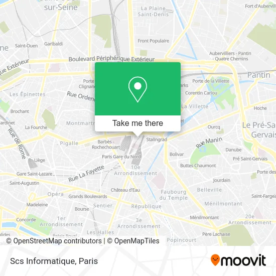
See Scs Informatique, Paris, on the map
Public Transit to Scs Informatique in Paris
Wondering how to get to Scs Informatique in Paris? Moovit helps you find the best way to get to Scs Informatique with step-by-step directions from the nearest public transit station.
Moovit provides free maps and live directions to help you navigate through your city. View schedules, routes, timetables, and find out how long does it take to get to Scs Informatique in real time.
Looking for the nearest stop or station to Scs Informatique? Check out this list of stops closest to your destination: La Chapelle; Philippe de Girard; Place de la Chapelle; Gare du Nord; Louis Blanc; Château Landon; Magenta.
Train: H, B, D, K, TER.RER: E.Metro: 2, 4, 7, 7B.Bus: 38, 43, 45, 54, 35, 302, N43, 48.
Want to see if there’s another route that gets you there at an earlier time? Moovit helps you find alternative routes or times. Get directions from and directions to Scs Informatique easily from the Moovit App or Website.
We make riding to Scs Informatique easy, which is why over 1.5 million users, including users in Paris, trust Moovit as the best app for public transit. You don’t need to download an individual bus app or train app, Moovit is your all-in-one transit app that helps you find the best bus time or train time available.
For information on prices of metro, bus, train and RER, costs and ride fares to Scs Informatique, please check the Moovit app.
Use the app to navigate to popular places including to the airport, hospital, stadium, grocery store, mall, coffee shop, school, college, and university.
Scs Informatique Address: Rue Louis Blanc street in Paris
- Mala,
- Louis Blanc - la Chapelle,
- VT Cash & Carry,
- Sirasa Entreprise,
- Aappa Kadai,
- Hells Angels Paris,
- 30 Rue Philippe de Girard,
- Pondichery,
- Krishna Bhavan,
- Quartier Indien,
- La Chapelle Île de France France,
- Thirupathy,
- 25 Rue Cail,
- Métro La Chapelle [2],
- Les Bouffes du Nord,
- le sans souci,
- Rue du Faubourg Saint-Denis,
- VS Co. Cash & Carry,
- Accès Gare du Nord (Rer B D E Lignes H Et K),
- Lycée Général Colbert
Places Near Scs Informatique (Paris)
- Théâtre Mogador, Paris,
- Institut Curie, Paris,
- Hôpital Necker, Paris,
- Gare Routière Flixbus, Paris,
- Hôpital Beaujon, Clichy,
- Hôpital de la Pitié-Salpêtrière, Paris,
- Galeries Lafayette, Paris,
- Galeries Lafayette Haussmann, Paris,
- Créteil Soleil, Creteil,
- Hôpital Henri Mondor, Creteil,
- Hopital Lariboisière, Paris,
- Marché Saint-Pierre, Paris,
- Atelier Des Lumieres, Paris,
- Hôpital Pitié Salpêtrière, Paris,
- Centre Hospitalier des 15/20, Paris,
- 29 Rue Manin, Paris,
- Hôpital Cochin, Paris,
- Fondation Louis Vuitton, Paris,
- Hôpital Saint-Joseph, Paris,
- Hopital Foch, Suresnes
How to get to popular places in Paris with public transit
Get around Paris by public transit!
Traveling around Paris has never been so easy. See step by step directions as you travel to any attraction, street or major public transit station. View bus and train schedules, arrival times, service alerts and detailed routes on a map, so you know exactly how to get to anywhere in Paris.
When traveling to any destination around Paris use Moovit's Live Directions with Get Off Notifications to know exactly where and how far to walk, how long to wait for your line, and how many stops are left. Moovit will alert you when it's time to get off — no need to constantly re-check whether yours is the next stop.
Wondering how to use public transit in Paris or how to pay for public transit in Paris? Moovit public transit app can help you navigate your way with public transit easily, and at minimum cost. It includes public transit fees, ticket prices, and costs. Looking for a map of Paris public transit lines? Moovit public transit app shows all public transit maps in Paris with all Bus, Train, Metro, Light Rail, RER, Funicular and Gondola routes and stops on an interactive map.
Paris has 7 transit type(s), including: Bus, Train, Metro, Light Rail, RER, Funicular and Gondola, operated by several transit agencies, including RATP, RER, RER Bus de remplacement, Train, Train Bus de remplacement, Tramway Bus de remplacement, TER, ADP, Magical Shuttle, Argenteuil - Boucles de Seine, Autocars Dominique, Bièvre, Brie et 2 Morin, Le Bus - C.C. du Clermontois and Cœur d’Essonne