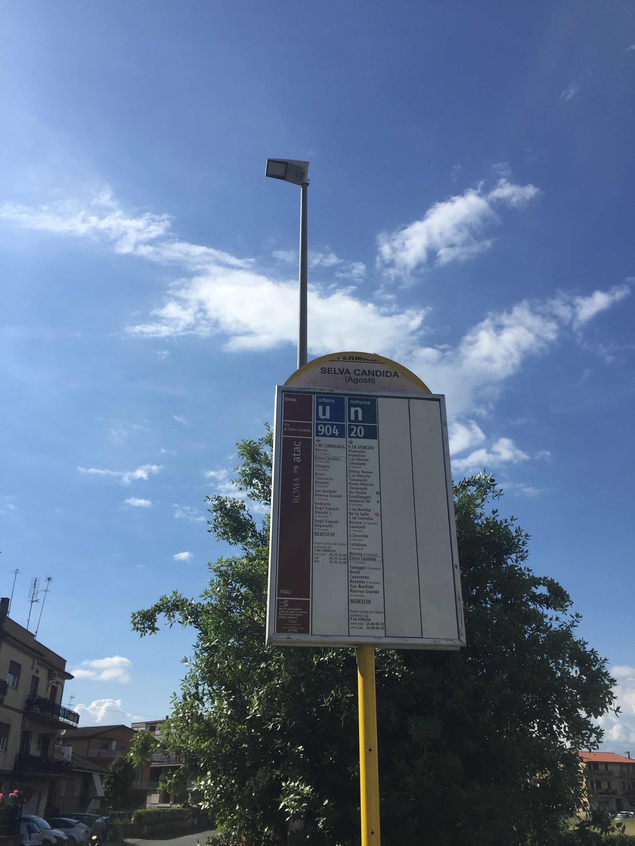
Selva Candida/Agosti stop - Monday schedule
| Line | Direction | Time |
|---|---|---|
| N904 | Bedeschi | 3:08 AM |
| N904 | Bedeschi | 3:08 AM |
| N904 | Bedeschi | 3:47 AM |
| N904 | Bedeschi | 3:47 AM |
| N904 | Bedeschi | 4:32 AM |
| N904 | Bedeschi | 4:32 AM |
| 904 | Bedeschi | 5:11 AM |
| N904 | Bedeschi | 5:17 AM |
| N904 | Bedeschi | 5:17 AM |
| 904 | Bedeschi | 5:33 AM |
| 904 | Bedeschi | 5:55 AM |
| 904 | Bedeschi | 6:17 AM |
| 904 | Bedeschi | 6:38 AM |
| 904 | Bedeschi | 7:04 AM |
| 904 | Bedeschi | 7:27 AM |
| 904 | Bedeschi | 7:52 AM |
| 904 | Bedeschi | 8:15 AM |
| 904 | Bedeschi | 8:39 AM |
| 904 | Bedeschi | 9:02 AM |
| 904 | Bedeschi | 9:26 AM |
| 904 | Bedeschi | 9:49 AM |
| 904 | Bedeschi | 10:12 AM |
| 904 | Bedeschi | 10:39 AM |
| 904 | Bedeschi | 11:06 AM |
| 904 | Bedeschi | 11:34 AM |
Directions to Selva Candida/Agosti stop (Roma) with public transit
The following transit lines have routes that pass near Selva Candida/Agosti
 Bus: 904, N904, 025, 031, 91.
- Metro: A.
How to get to Selva Candida/Agosti stop by bus?
Click on the bus route to see step by step directions with maps, line arrival times and updated time schedules.
Bus stops near Selva Candida/Agosti stop in Roma
- Boccea/Casalotti, 2 min walk,
- Casalotti/Boccea, 4 min walk,
- Borgo Ticino, 7 min walk,
Metro stations near Selva Candida/Agosti station in Roma
- Battistini, 33 min walk,
Bus lines to Selva Candida/Agosti stop in Roma
- 904, Selva Candida - Cornelia (MA),
- N904, Selva Candida - Piazza Venezia,
- 025, Casalotti - Testa di Lepre,
- 031, La Giustiniana (Railway) - Selva Nera,
- 91, Battistini/Soria,
- 905, Cornelia (MA),
- 028, San Basilide,
- 146, Mombasiglio,
- 027, Borgo Ticino,
What are the closest stations to Selva Candida/Agosti?
The closest stations to Selva Candida/Agosti are:
- Boccea/Casalotti stop is 126 meters away, 2 min walk.
- Casalotti/Boccea stop is 269 meters away, 4 min walk.
- Borgo Ticino stop is 490 meters away, 7 min walk.
- Battistini station is 2603 meters away, 33 min walk.
Which bus line stops near Selva Candida/Agosti?
904 (Bedeschi)
What’s the nearest bus station to Selva Candida/Agosti in Roma?
The nearest bus station to Selva Candida/Agosti in Roma is Boccea/Casalotti. It’s a 2 min walk away.
What time is the first metro to Selva Candida/Agosti in Roma?
The A is the first metro that goes to Selva Candida/Agosti in Roma. It stops nearby at 5:30 AM.
What time is the last metro to Selva Candida/Agosti in Roma?
The A is the last metro that goes to Selva Candida/Agosti in Roma. It stops nearby at 12:11 AM.
What time is the first bus to Selva Candida/Agosti in Roma?
The N904 is the first bus that goes to Selva Candida/Agosti in Roma. It stops nearby at 3:00 AM.
What time is the last bus to Selva Candida/Agosti in Roma?
The N904 is the last bus that goes to Selva Candida/Agosti in Roma. It stops nearby at 3:10 AM.
Selva Candida/Agosti station
 Taken by Anonymous
See Selva Candida/Agosti stop, Roma, on the map
Public transit to Selva Candida/Agosti stop (ID: 75622) in Roma
Looking for directions to Selva Candida/Agosti in Roma, Italy?
Download the Moovit App to find the current schedule and step-by-step directions for Bus, Metro or Train routes that pass through Selva Candida/Agosti.
Looking for the nearest stops closest to Selva Candida/Agosti ? Check out this list of closest stops to your destination: Boccea/Casalotti; Casalotti/Boccea; Borgo Ticino; Battistini.
Bus: 904, N904, 025, 031, 91, 905, 028, 146, 027.Metro: A.
We make riding on public transit to Selva Candida/Agosti easy, which is why over 1.7 billion users, including users in Roma trust Moovit as the best app for public transit.
Use the app to navigate to popular places including to the airport, hospital, stadium, grocery store, mall, coffee shop, school, college, and university.
Selva Candida/Agosti stop’s code is 75622
The first line to this stop is N904, at 3:08 AM, and the last line is N904 at 2:23 AM.
This stop serves ATAC’s lines
- Boccea/Casalotti,
- Casalotti/Boccea,
- Borgo Ticino
Bus stops near Selva Candida/Agosti stop
- Battistini
Metro station near Selva Candida/Agosti station
- Navicella/Villa Celimontana,
- Sora | Railway Station,
- Fucini/Bufalotta,
- Portonaccio/Tiburtina,
- Casale S. Basilio/Nomentana,
- Giuseppe Di Vittorio Street,
- Cavalleggeri/Fornaci,
- Via Palombarese - Via Santa Lucia, Fonte Nuova,
- Ottavia,
- Rattazzi/Giolitti,
- Tor Vergata Hospital,
- Emporio,
- Rocca Priora | Colle Di Fuori,
- Prenestina/GRA,
- Colli Portuensi/Artom,
- Cola Di Rienzo/Regolo,
- Saxa Rubra Station,
- Leonardo Park,
- Ladispoli, Falcone Square,
- Giolitti
Popular public transit stations in Roma
Get around Roma by public transit!
Traveling around Roma has never been so easy. See step by step directions as you travel to any attraction, street or major public transit station. View bus and train schedules, arrival times, service alerts and detailed routes on a map, so you know exactly how to get to anywhere in Roma.
When traveling to any destination around Roma use Moovit's Live Directions with Get Off Notifications to know exactly where and how far to walk, how long to wait for your line, and how many stops are left. Moovit will alert you when it's time to get off — no need to constantly re-check whether yours is the next stop.
Wondering how to use public transit in Roma or how to pay for public transit in Roma? Moovit public transit app can help you navigate your way with public transit easily, and at minimum cost. It includes public transit fees, ticket prices, and costs. Looking for a map of Roma public transit lines? Moovit public transit app shows all public transit maps in Roma with all Bus, Train, Metro, Light Rail, Ferry, Funicular and Gondola routes and stops on an interactive map.
Rome and Lazio has 7 transit type(s), including: Bus, Train, Metro, Light Rail, Ferry, Funicular and Gondola, operated by several transit agencies, including ATAC, Cotral, Trenitalia, Troiani Transportation Services, BIS, ATR Mobility, Tuscia, Shuttle, Seatour, Troiani Bus Lines, CSC Mobility, Terravision, ATRAL, Tambus and Sitbus