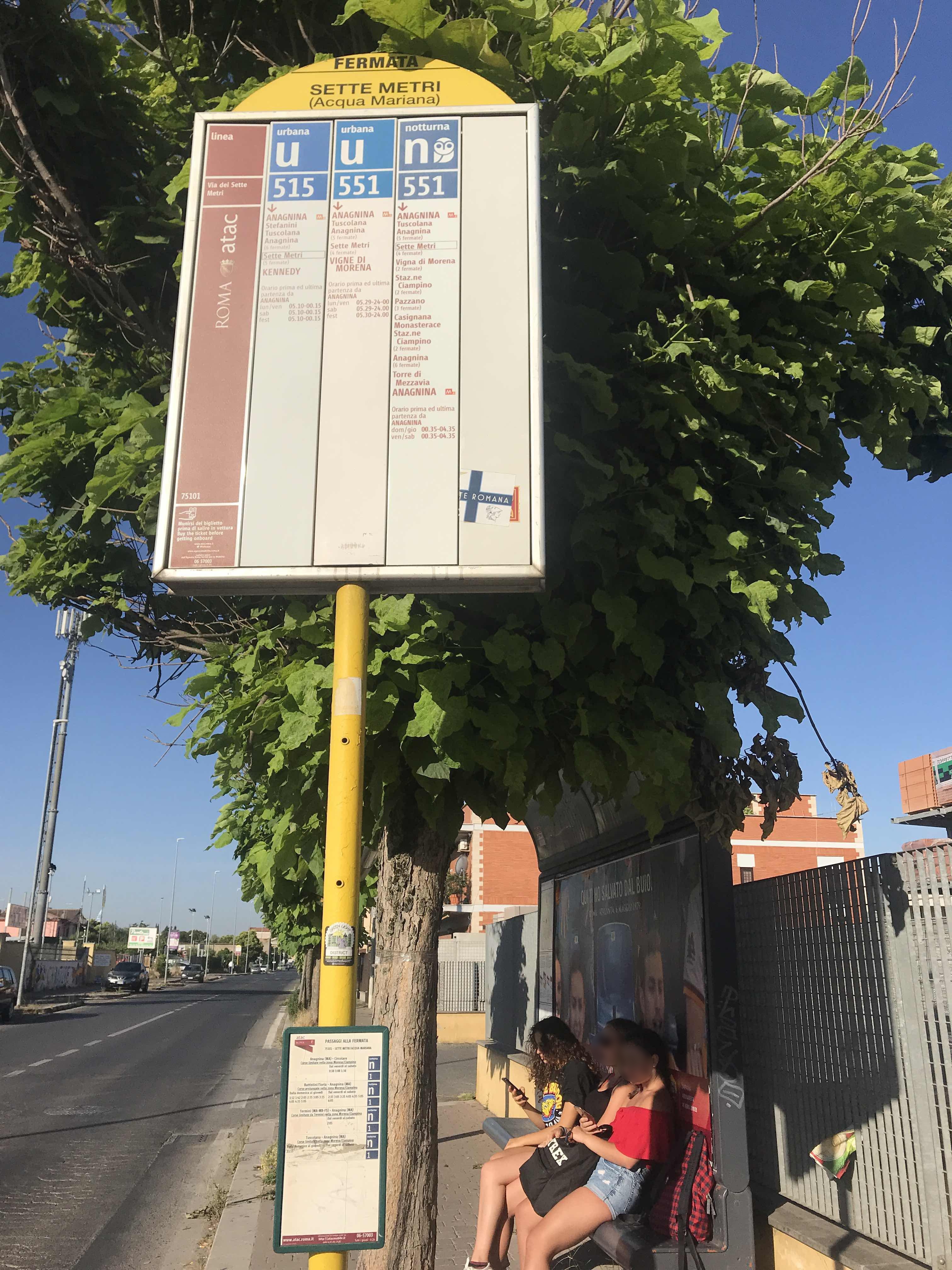
Seven Meters/Acqua Mariana stop - Wednesday schedule
| Line | Direction | Time |
|---|---|---|
| N551 | Anagnina Metro | 3:13 AM |
| N551 | Anagnina Metro | 3:13 AM |
| N551 | Anagnina Metro | 3:43 AM |
| N551 | Anagnina Metro | 3:43 AM |
| N551 | Anagnina Metro | 4:13 AM |
| N551 | Anagnina Metro | 4:13 AM |
| N551 | Anagnina Metro | 4:43 AM |
| N551 | Anagnina Metro | 4:43 AM |
| 515 | Kennedy/Ciampino Railway Station | 5:03 AM |
| 551 | Vigne Di Morena | 5:08 AM |
| 515 | Kennedy/Ciampino Railway Station | 5:22 AM |
| 515 | Kennedy/Ciampino Railway Station | 5:38 AM |
| 551 | Vigne Di Morena | 5:38 AM |
| 515 | Kennedy/Ciampino Railway Station | 5:53 AM |
| 551 | Vigne Di Morena | 5:58 AM |
| 515 | Kennedy/Ciampino Railway Station | 6:09 AM |
| 551 | Vigne Di Morena | 6:18 AM |
| 515 | Kennedy/Ciampino Railway Station | 6:25 AM |
| 551 | Vigne Di Morena | 6:38 AM |
| 515 | Kennedy/Ciampino Railway Station | 6:40 AM |
| 515 | Kennedy/Ciampino Railway Station | 6:56 AM |
| 551 | Vigne Di Morena | 6:58 AM |
| 515 | Kennedy/Ciampino Railway Station | 7:12 AM |
| 551 | Vigne Di Morena | 7:13 AM |
| 515 | Kennedy/Ciampino Railway Station | 7:24 AM |
Directions to Seven Meters/Acqua Mariana stop (Roma) with public transit
The following transit lines have routes that pass near Seven Meters/Acqua Mariana
 Bus: 515, 551, AIRLINK, SITBUS, 507.
- Train: FL4, R, FL6.
- Metro: A.
How to get to Seven Meters/Acqua Mariana stop by bus?
Click on the bus route to see step by step directions with maps, line arrival times and updated time schedules.
How to get to Seven Meters/Acqua Mariana stop by train?
Click on the train route to see step by step directions with maps, line arrival times and updated time schedules.
How to get to Seven Meters/Acqua Mariana stop by metro?
Click on the metro route to see step by step directions with maps, line arrival times and updated time schedules.
Bus stops near Seven Meters/Acqua Mariana stop in Roma
- Sette Metri/Torre Morena, 3 min walk,
- Anagnina/Calpurnio Bellico, 3 min walk,
- Anagnina/Sette Metri, 6 min walk,
Metro stations near Seven Meters/Acqua Mariana station in Roma
- Anagnina, 49 min walk,
Train stations near Seven Meters/Acqua Mariana station in Roma
- Ciampino, 52 min walk,
Bus lines to Seven Meters/Acqua Mariana stop in Roma
- 515, Anagnina Metro,
- 507, Grotte Celoni,
- 551, Vigne Di Morena,
- N551, Anagnina Metro,
- 505, Anagnina Metro Station Line A,
- COTRAL, Marino - Roma Anagnina,
- COTRAL, Rocca Priora - Roma Anagnina,
- COTRAL, Rocca Di Papa - Roma Anagnina,
- COTRAL, Colleferro Scalo - Roma Anagnina,
- COTRAL, Rocca Di Papa to Campi Di Annibale,
- COTRAL, Colleferro | Railway Station,
- COTRAL, Marino Matteotti Square,
- COTRAL, Castel Gandolfo Bus Terminal,
- COTRAL, Colleferro | Largo Oberdan,
- COTRAL, Rocca Priora via Largo Pallotti,
What are the closest stations to Seven Meters/Acqua Mariana?
The closest stations to Seven Meters/Acqua Mariana are:
- Sette Metri/Torre Morena stop is 164 meters away, 3 min walk.
- Anagnina/Calpurnio Bellico stop is 168 meters away, 3 min walk.
- Anagnina/Sette Metri stop is 424 meters away, 6 min walk.
- Anagnina station is 3826 meters away, 49 min walk.
- Ciampino station is 4140 meters away, 52 min walk.
Which bus lines stop near Seven Meters/Acqua Mariana?
These bus lines stop near Seven Meters/Acqua Mariana: 515, 551, AIRLINK, SITBUS.
Which train line stops near Seven Meters/Acqua Mariana?
FL4 (Frascati/Albano/Velletri)
Which metro line stops near Seven Meters/Acqua Mariana?
A (Anagnina)
What’s the nearest bus station to Seven Meters/Acqua Mariana in Roma?
The nearest bus stations to Seven Meters/Acqua Mariana in Roma are Sette Metri/Torre Morena and Anagnina/Calpurnio Bellico. The closest one is a 3 min walk away.
What time is the first metro to Seven Meters/Acqua Mariana in Roma?
The A is the first metro that goes to Seven Meters/Acqua Mariana in Roma. It stops nearby at 5:30 AM.
What time is the last metro to Seven Meters/Acqua Mariana in Roma?
The A is the last metro that goes to Seven Meters/Acqua Mariana in Roma. It stops nearby at 12:12 AM.
What time is the first train to Seven Meters/Acqua Mariana in Roma?
The FL6 is the first train that goes to Seven Meters/Acqua Mariana in Roma. It stops nearby at 6:11 AM.
What time is the last train to Seven Meters/Acqua Mariana in Roma?
The FL6 is the last train that goes to Seven Meters/Acqua Mariana in Roma. It stops nearby at 10:41 PM.
What time is the first bus to Seven Meters/Acqua Mariana in Roma?
The N551 is the first bus that goes to Seven Meters/Acqua Mariana in Roma. It stops nearby at 3:13 AM.
What time is the last bus to Seven Meters/Acqua Mariana in Roma?
The N551 is the last bus that goes to Seven Meters/Acqua Mariana in Roma. It stops nearby at 2:51 AM.
Seven Meters/Acqua Mariana station
 Taken by Anonymous
See Seven Meters/Acqua Mariana stop, Roma, on the map
Public transit to Seven Meters/Acqua Mariana stop (ID: 75101) in Roma
Looking for directions to Seven Meters/Acqua Mariana in Roma, Italy?
Download the Moovit App to find the current schedule and step-by-step directions for Bus, Metro or Train routes that pass through Seven Meters/Acqua Mariana.
Looking for the nearest stops closest to Seven Meters/Acqua Mariana ? Check out this list of closest stops to your destination: Sette Metri/Torre Morena; Anagnina/Calpurnio Bellico; Anagnina/Sette Metri; Anagnina; Ciampino.
Bus: 515, 551, AIRLINK, SITBUS, 507, N551, 505, COTRAL, COTRAL, COTRAL, COTRAL, COTRAL, COTRAL, COTRAL, COTRAL, COTRAL.Train: FL4, R, FL6.Metro: A.
We make riding on public transit to Seven Meters/Acqua Mariana easy, which is why over 1.7 billion users, including users in Roma trust Moovit as the best app for public transit.
Use the app to navigate to popular places including to the airport, hospital, stadium, grocery store, mall, coffee shop, school, college, and university.
Seven Meters/Acqua Mariana stop’s code is 75101
The first line to this stop is N551, at 3:13 AM, and the last line is N551 at 2:43 AM.
42 / 44 Via dei Sette Metri, Roma, Italy
This stop serves ATAC’s lines
- Sette Metri/Torre Morena,
- Anagnina/Calpurnio Bellico,
- Anagnina/Sette Metri
Bus stops near Seven Meters/Acqua Mariana stop
- Anagnina
Metro station near Seven Meters/Acqua Mariana station
- Ciampino
Train station near Seven Meters/Acqua Mariana station
- Trionfale/Pineta Sacchetti,
- San Lorenzo | Cassia Road (Km 122),
- Branca,
- Ladispoli, Monteroni Street (Near Recin),
- Giuseppe Garibaldi Square, 14,
- Calice/Bova,
- Capannelle,
- Rome | Salaria Road (Quattro Cancelli),
- Colombo/Malafede,
- Frosinone | Pertini Square,
- Senate,
- Vetralla Street,
- Roma | Sant'Eugenio Hospital,
- Poggio Nativo | Salaria Road (Km 51),
- Stella Polare,
- Cave Ardeatine/Pyramid (Mb),
- Via Manzoni/Tor Lupara,
- America/Tolstoi,
- Aventino,
- Villa Claudia
Popular public transit stations in Roma
Get around Roma by public transit!
Traveling around Roma has never been so easy. See step by step directions as you travel to any attraction, street or major public transit station. View bus and train schedules, arrival times, service alerts and detailed routes on a map, so you know exactly how to get to anywhere in Roma.
When traveling to any destination around Roma use Moovit's Live Directions with Get Off Notifications to know exactly where and how far to walk, how long to wait for your line, and how many stops are left. Moovit will alert you when it's time to get off — no need to constantly re-check whether yours is the next stop.
Wondering how to use public transit in Roma or how to pay for public transit in Roma? Moovit public transit app can help you navigate your way with public transit easily, and at minimum cost. It includes public transit fees, ticket prices, and costs. Looking for a map of Roma public transit lines? Moovit public transit app shows all public transit maps in Roma with all Bus, Train, Metro, Light Rail, Ferry, Funicular and Gondola routes and stops on an interactive map.
Rome and Lazio has 7 transit type(s), including: Bus, Train, Metro, Light Rail, Ferry, Funicular and Gondola, operated by several transit agencies, including ATAC, Cotral, Trenitalia, Troiani Transportation Services, BIS, ATR Mobility, Tuscia, Shuttle, Seatour, Troiani Bus Lines, CSC Mobility, Terravision, ATRAL, Tambus and Sitbus