How to get to Shell Maagdenstraat by bus?
Click on the bus route to see step by step directions with maps, line arrival times and updated time schedules.
From Rasoelbaks, Koewarasan
48 minFrom Cbb Kantoor Welgedacht B, De Nieuwe Grond
45 minFrom TBL Cinemas, Beekhuizen
26 minFrom Apotheek Joemmanbaks, Flora
28 minFrom Politiepost de Nieuwe Grond, De Nieuwe Grond
40 minFrom Samuel Glöckler School, Margaretha
73 minFrom Gebouw 7, Tammenga
36 minFrom Satish Music Centre, De Nieuwe Grond
44 minFrom Suda Roti Restaurant, Welgelegen
27 minFrom Voorburg, Margaretha
68 min
Bus stops near Shell Maagdenstraat in Centrum
Ferry station near Shell Maagdenstraat in Centrum
- Vreedzaam Markt, 7 min walk,VIEW
Bus lines to Shell Maagdenstraat in Centrum
- L6, Maagdenstr,VIEW
- L7, Latourweg,VIEW
- L8, Adek University,VIEW
- L9, Chm,VIEW
- L3, Vreedzaam Markt,VIEW
- L5, Guaranistr,VIEW
- L2, Parking Place,VIEW
- PBO, Paramaribo - Biliton - Onverwacht,VIEW
- PK, Paramaribo - Kwatta,VIEW
- PL, Paramaribo - Lelydorp,VIEW
- PLH, Paramaribo - Luchthaven,VIEW
- PNA, Paramaribo - Nieuw-Amsterdam,VIEW
- POB, Paramaribo - Onverwacht - Biliton,VIEW
- POZ, Paramaribo - Onverwacht - Zanderij,VIEW
- PRVZ, Paramaribo - Republiek - Vierkinderen - Zanderij,VIEW
- PSB, Paramaribo - Santo Boma,VIEW
What are the closest stations to Shell Maagdenstraat?
The closest stations to Shell Maagdenstraat are:
- Dr. Sophie Redmond Straat, 22 is 103 meters away, 2 min walk.
- Dominee Straat, 21 is 203 meters away, 3 min walk.
- Saramacca Straat, 17 is 277 meters away, 4 min walk.
- A.L. Waaldijk Straat, 11 is 436 meters away, 6 min walk.
- Vreedzaam Markt is 517 meters away, 7 min walk.
Which bus lines stop near Shell Maagdenstraat?
These bus lines stop near Shell Maagdenstraat: L4, L8, L9, PK, PL, PNA, POB, PSB.
What’s the nearest bus station to Shell Maagdenstraat in Centrum?
The nearest bus station to Shell Maagdenstraat in Centrum is Dr. Sophie Redmond Straat, 22. It’s a 2 min walk away.
What’s the nearest ferry station to Shell Maagdenstraat in Centrum?
The nearest ferry station to Shell Maagdenstraat in Centrum is Vreedzaam Markt. It’s a 7 min walk away.
What time is the first bus to Shell Maagdenstraat in Centrum?
The L6 is the first bus that goes to Shell Maagdenstraat in Centrum. It stops nearby at 4:07 AM.
What time is the last bus to Shell Maagdenstraat in Centrum?
The PNA is the last bus that goes to Shell Maagdenstraat in Centrum. It stops nearby at 12:19 AM.
What time is the first ferry to Shell Maagdenstraat in Centrum?
The F1 is the first ferry that goes to Shell Maagdenstraat in Centrum. It stops nearby at 5:02 AM.
What time is the last ferry to Shell Maagdenstraat in Centrum?
The F1 is the last ferry that goes to Shell Maagdenstraat in Centrum. It stops nearby at 11:02 PM.
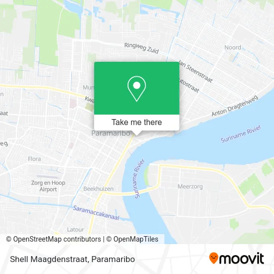
See Shell Maagdenstraat, Centrum, on the map
Public Transit to Shell Maagdenstraat in Centrum
Wondering how to get to Shell Maagdenstraat in Centrum? Moovit helps you find the best way to get to Shell Maagdenstraat with step-by-step directions from the nearest public transit station.
Moovit provides free maps and live directions to help you navigate through your city. View schedules, routes, timetables, and find out how long does it take to get to Shell Maagdenstraat in real time.
Looking for the nearest stop or station to Shell Maagdenstraat? Check out this list of stops closest to your destination: Dr. Sophie Redmond Straat; Dominee Straat; Saramacca Straat; A.L. Waaldijk Straat; Vreedzaam Markt.
Bus: L4, L8, L9, PK, PL, PNA, POB, PSB, L6, L7, L3, L5, L2, PBO, PLH.Ferry: F1.
Want to see if there’s another route that gets you there at an earlier time? Moovit helps you find alternative routes or times. Get directions from and directions to Shell Maagdenstraat easily from the Moovit App or Website.
We make riding to Shell Maagdenstraat easy, which is why over 1.5 million users, including users in Centrum, trust Moovit as the best app for public transit. You don’t need to download an individual bus app or train app, Moovit is your all-in-one transit app that helps you find the best bus time or train time available.
For information on prices of bus and ferry, costs and ride fares to Shell Maagdenstraat, please check the Moovit app.
Use the app to navigate to popular places including to the airport, hospital, stadium, grocery store, mall, coffee shop, school, college, and university.
Shell Maagdenstraat Address: Maagdenstraat Centrum, Paramaribo street in Centrum
- Money Trans,
- Maagdenstraat 61,
- Money Line N.V.,
- Hakrinbank NV,
- Grote Stadskerk EBGS,
- Kong Ngie Tong Sang,
- Romano,
- Unioa,
- Ourominas,
- Chiu Hung's Reisbureau Nv,
- McDonald's Suriname,
- X - Moom,
- Alladin Confectie Maatkleding,
- Nam Tong Cellshop,
- Man Wah,
- Popeyes,
- Dankbaarheidsmonument,
- Popeyes Chicken & Biscuits,
- Chm Reisbureau,
- Midnight Restaurant
Places Near Shell Maagdenstraat (Centrum)
- Plantage Frederiksdorp, Margaretha,
- Veerplein, Meerzorg,
- Scholengemeenschap Sanatan Dharma Sgs, Livorno,
- Warung Monica N.V. & Essy Crew, Rainville,
- Bus Station Lijn 6, Centrum,
- Academisch Ziekenhuis Paramaribo, Centrum,
- Bus Station Tamkas, Centrum,
- Diakonessenhuis, Centrum,
- Mei Da Bouwmarkt, Centrum,
- PO/PBO Busstation, Centrum,
- Drs. H. R. Gooswit, Lelydorp,
- Ondro Bong, Paramaribo, Centrum,
- Bus Station Plk, Centrum,
- O. S. Welgedacht C, De Nieuwe Grond,
- Hermitage Mall, Beekhuizen,
- Peperpot Nature Park, Meerzorg,
- Johan Adolf Pengel International Airport | Paramaribo-Zanderij International Airport | PBM, Zuid,
- Charlesburg, Rainville,
- DHL Express Suriname, Centrum,
- Nationaal Vervoer Bedrijf N.V., Meerzorg
How to get to popular places in Paramaribo with public transit
Get around Centrum by public transit!
Traveling around Centrum has never been so easy. See step by step directions as you travel to any attraction, street or major public transit station. View bus and train schedules, arrival times, service alerts and detailed routes on a map, so you know exactly how to get to anywhere in Centrum.
When traveling to any destination around Centrum use Moovit's Live Directions with Get Off Notifications to know exactly where and how far to walk, how long to wait for your line, and how many stops are left. Moovit will alert you when it's time to get off — no need to constantly re-check whether yours is the next stop.
Wondering how to use public transit in Centrum or how to pay for public transit in Centrum? Moovit public transit app can help you navigate your way with public transit easily, and at minimum cost. It includes public transit fees, ticket prices, and costs. Looking for a map of Centrum public transit lines? Moovit public transit app shows all public transit maps in Centrum with all Bus and Ferry routes and stops on an interactive map.
Paramaribo has 2 transit type(s), including: Bus and Ferry, operated by several transit agencies, including P.L.O. and Suriname Ferry