How to get to Softgrid by train?
Click on the train route to see step by step directions with maps, line arrival times and updated time schedules.
Train stations near Softgrid in Stuttgart
What are the closest stations to Softgrid?
The closest stations to Softgrid are:
- Landau, Hauptbahnhof is 667 meters away, 9 min walk.
- Landau, Süd is 1727 meters away, 23 min walk.
- Landau, Westbahnhof is 1821 meters away, 25 min walk.
Which train lines stop near Softgrid?
These train lines stop near Softgrid: RB51, RB53, RB55, RE6.
What’s the nearest train station to Softgrid in Stuttgart?
The nearest train station to Softgrid in Stuttgart is Landau, Hauptbahnhof. It’s a 9 min walk away.
What time is the first train to Softgrid in Stuttgart?
The RB51 is the first train that goes to Softgrid in Stuttgart. It stops nearby at 4:49 AM.
What time is the last train to Softgrid in Stuttgart?
The RE6 is the last train that goes to Softgrid in Stuttgart. It stops nearby at 11:58 PM.
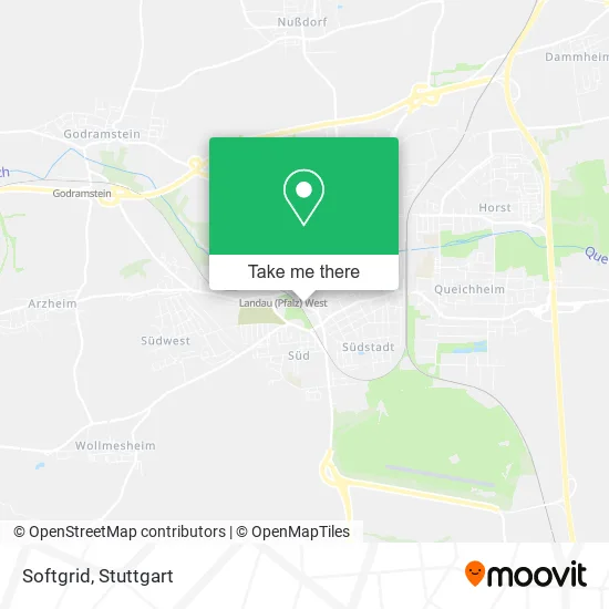
See Softgrid, Stuttgart, on the map
Public Transit to Softgrid in Stuttgart
Wondering how to get to Softgrid in Stuttgart? Moovit helps you find the best way to get to Softgrid with step-by-step directions from the nearest public transit station.
Moovit provides free maps and live directions to help you navigate through your city. View schedules, routes, timetables, and find out how long does it take to get to Softgrid in real time.
Looking for the nearest stop or station to Softgrid? Check out this list of stops closest to your destination: Landau; Landau; Landau.
Train: RB51, RB53, RB55, RE6, RB54.
Want to see if there’s another route that gets you there at an earlier time? Moovit helps you find alternative routes or times. Get directions from and directions to Softgrid easily from the Moovit App or Website.
We make riding to Softgrid easy, which is why over 1.7 million users, including users in Stuttgart, trust Moovit as the best app for public transit. You don’t need to download an individual bus app or train app, Moovit is your all-in-one transit app that helps you find the best bus time or train time available.
For information on prices of train, light rail and bus, costs and ride fares to Softgrid, please check the Moovit app.
Use the app to navigate to popular places including to the airport, hospital, stadium, grocery store, mall, coffee shop, school, college, and university.
Softgrid Address: Südring 1 76829 Landau in der Pfalz street in Stuttgart
- Aw Construction GmbH & Co,
- Wehnl Administration,
- Itc Projektgesellschaft Mainz,
- Adalbert Heim,
- Dpvkom RV Südwest,
- Marx & Sterzing Rechtsanwälte,
- Tangotaverne,
- Marion E. Jaspers,
- Cbc,
- Hf-Medizin-Elektronik Vertriebs,
- Swa,
- Gerd Krämer,
- Südpfalz Immobilien,
- Fuimo,
- Bf Projekt,
- About Socks,
- Rooxs,
- Deyun,
- Sr Projektgmbh,
- Maisenbacher, Hort & Partner Steuerberater Rechtsanwalt
Places Near Softgrid (Stuttgart)
- Klinikum Stuttgart - Katharinenhospital, Stuttgart-Mitte,
- Porsche-Arena, Bad Cannstatt,
- Im Wizemann (Halle), Bad Cannstatt,
- Mercedes-Benz Museum (Mercedes Museum Stuttgart), Bad Cannstatt,
- Mettingen Eros-Center Puff Laufhaus, Esslingen Am Neckar,
- Hauptbahnhof Stuttgart, Stuttgart-Mitte,
- Waldfriedhof, Degerloch,
- Gasometer Pforzheim, Pforzheim,
- Porsche Museum, Zuffenhausen,
- SI-Centrum, Möhringen,
- Mercedes-Benz Museum, Bad Cannstatt,
- FlixBus Haltestelle, Stuttgart,
- Hanns-Martin-Schleyer-Halle, Bad Cannstatt,
- Wilhelma (U-Bahn Wilhelma), Bad Cannstatt,
- Pariser Platz Stuttgart, Stuttgart-Mitte,
- Geilhaus Haus 33a, Reutlingen-Betzingen,
- Gleis 101/102 (tief), Stuttgart-Mitte,
- Hanns-Martin-Schleyer-Halle (Stuttgart Hans-Martin-Schleyerhalle), Bad Cannstatt,
- Schleyerhalle, Bad Cannstatt,
- Marmorsaal Im Weissenburgpark, Stuttgart-Süd
How to get to popular places in Stuttgart with public transit
Get around Stuttgart by public transit!
Traveling around Stuttgart has never been so easy. See step by step directions as you travel to any attraction, street or major public transit station. View bus and train schedules, arrival times, service alerts and detailed routes on a map, so you know exactly how to get to anywhere in Stuttgart.
When traveling to any destination around Stuttgart use Moovit's Live Directions with Get Off Notifications to know exactly where and how far to walk, how long to wait for your line, and how many stops are left. Moovit will alert you when it's time to get off — no need to constantly re-check whether yours is the next stop.
Wondering how to use public transit in Stuttgart or how to pay for public transit in Stuttgart? Moovit public transit app can help you navigate your way with public transit easily, and at minimum cost. It includes public transit fees, ticket prices, and costs. Looking for a map of Stuttgart public transit lines? Moovit public transit app shows all public transit maps in Stuttgart with all Bus, Train, Subway, Light Rail, Ferry, S-Bahn and Funicular routes and stops on an interactive map.
Stuttgart has 7 transit type(s), including: Bus, Train, Subway, Light Rail, Ferry, S-Bahn and Funicular, operated by several transit agencies, including SSB - Stadtbahn, SSB, SSB - Seilbahn / Zacke, S-Bahn Stuttgart, Rhein-Neckar-Verkehr GmbH (rnv), Karlsruher Verkehrsverbund, DB AG, DB Regiobus BW, Arverio Baden-Württemberg GmbH, DB RegioNetz Verkehrs GmbH Westfrankenbahn, DB Regio AG Baden-Württemberg, Südwestdeutsche Verkehrs-AG, DB Regio AG Mitte Region Hessen, DB and Bodensee-Oberschwaben-Bahn