St. Helen's stop - Sunday schedule
| Line | Direction | Time |
|---|---|---|
| L51 | Liffey Valley Sc | 7:52 AM |
| L52 | Blanchardstown Sc | 8:22 AM |
| L51 | Liffey Valley Sc | 8:58 AM |
| L52 | Blanchardstown Sc | 9:28 AM |
| L51 | Liffey Valley Sc | 9:58 AM |
| L52 | Blanchardstown Sc | 10:28 AM |
| L51 | Liffey Valley Sc | 10:58 AM |
| L52 | Blanchardstown Sc | 11:33 AM |
| L51 | Liffey Valley Sc | 11:59 AM |
| L52 | Blanchardstown Sc | 12:32 PM |
| L51 | Liffey Valley Sc | 12:59 PM |
| L52 | Blanchardstown Sc | 1:34 PM |
| L51 | Liffey Valley Sc | 1:59 PM |
| L52 | Blanchardstown Sc | 2:33 PM |
| L51 | Liffey Valley Sc | 2:59 PM |
| L52 | Blanchardstown Sc | 3:33 PM |
| L51 | Liffey Valley Sc | 3:59 PM |
| L52 | Blanchardstown Sc | 4:33 PM |
| L51 | Liffey Valley Sc | 4:58 PM |
| L52 | Blanchardstown Sc | 5:33 PM |
| L51 | Liffey Valley Sc | 5:58 PM |
| L52 | Blanchardstown Sc | 6:32 PM |
| L51 | Liffey Valley Sc | 6:59 PM |
| L52 | Blanchardstown Sc | 7:32 PM |
| L51 | Liffey Valley Sc | 7:58 PM |
Directions to St. Helen's stop (Lucan-St. Helen'S) with public transit
The following transit lines have routes that pass near St. Helen's
 Bus: C1, L51, L52, X30, C2.
- Train: COMMUTER, RAIL, RAIL.
How to get to St. Helen's stop by bus?
Click on the bus route to see step by step directions with maps, line arrival times and updated time schedules.
How to get to St. Helen's stop by train?
Click on the train route to see step by step directions with maps, line arrival times and updated time schedules.
Bus stops near St. Helen's stop in Lucan-St. Helen'S
- Shackleton Point, 4 min walk,
- The Paddocks Drive, 9 min walk,
- Shackleton Drive, 9 min walk,
Train stations near St. Helen's station in Lucan-St. Helen'S
- Adamstown, 25 min walk,
- Leixlip(Confey), 64 min walk,
Bus lines to St. Helen's stop in Lucan-St. Helen'S
- L51, Adamstown Station,
- L52, Blanchardstown Sc,
- X30, Adamstown Station,
- C2, Adamstown Station,
What are the closest stations to St. Helen's?
The closest stations to St. Helen's are:
- Shackleton Point stop is 270 meters away, 4 min walk.
- The Paddocks Drive stop is 642 meters away, 9 min walk.
- Shackleton Drive stop is 643 meters away, 9 min walk.
- Adamstown station is 1932 meters away, 25 min walk.
- Leixlip(Confey) station is 4966 meters away, 64 min walk.
Which bus lines stop near St. Helen's?
These bus lines stop near St. Helen's: C1, L51, L52.
Which train line stops near St. Helen's?
COMMUTER (Dublin Heuston→Portlaoise)
What’s the nearest train station to St. Helen's in Lucan-St. Helen'S?
The nearest train station to St. Helen's in Lucan-St. Helen'S is Adamstown. It’s a 25 min walk away.
What’s the nearest bus station to St. Helen's in Lucan-St. Helen'S?
The nearest bus station to St. Helen's in Lucan-St. Helen'S is Shackleton Point. It’s a 4 min walk away.
What time is the first train to St. Helen's in Lucan-St. Helen'S?
The RAIL is the first train that goes to St. Helen's in Lucan-St. Helen'S. It stops nearby at 8:17 AM.
What time is the last train to St. Helen's in Lucan-St. Helen'S?
The RAIL is the last train that goes to St. Helen's in Lucan-St. Helen'S. It stops nearby at 11:59 PM.
What time is the first bus to St. Helen's in Lucan-St. Helen'S?
The C2 is the first bus that goes to St. Helen's in Lucan-St. Helen'S. It stops nearby at 3:10 AM.
What time is the last bus to St. Helen's in Lucan-St. Helen'S?
The C2 is the last bus that goes to St. Helen's in Lucan-St. Helen'S. It stops nearby at 3:06 AM.
St. Helen's station
 Taken by Anonymous
See St. Helen's stop, Lucan-St. Helen'S, on the map
Public transit to St. Helen's stop (ID: 7986) in Lucan-St. Helen'S
Looking for directions to St. Helen's in Lucan-St. Helen'S, Ireland?
Download the Moovit App to find the current schedule and step-by-step directions for Bus or Train routes that pass through St. Helen's.
Looking for the nearest stops closest to St. Helen's ? Check out this list of closest stops to your destination: Shackleton Point; The Paddocks Drive; Shackleton Drive; Adamstown; Leixlip(Confey).
Bus: C1, L51, L52, X30, C2.Train: COMMUTER, RAIL, RAIL.
We make riding on public transit to St. Helen's easy, which is why over 1.7 billion users, including users in Lucan-St. Helen'S trust Moovit as the best app for public transit.
Use the app to navigate to popular places including to the airport, hospital, stadium, grocery store, mall, coffee shop, school, college, and university.
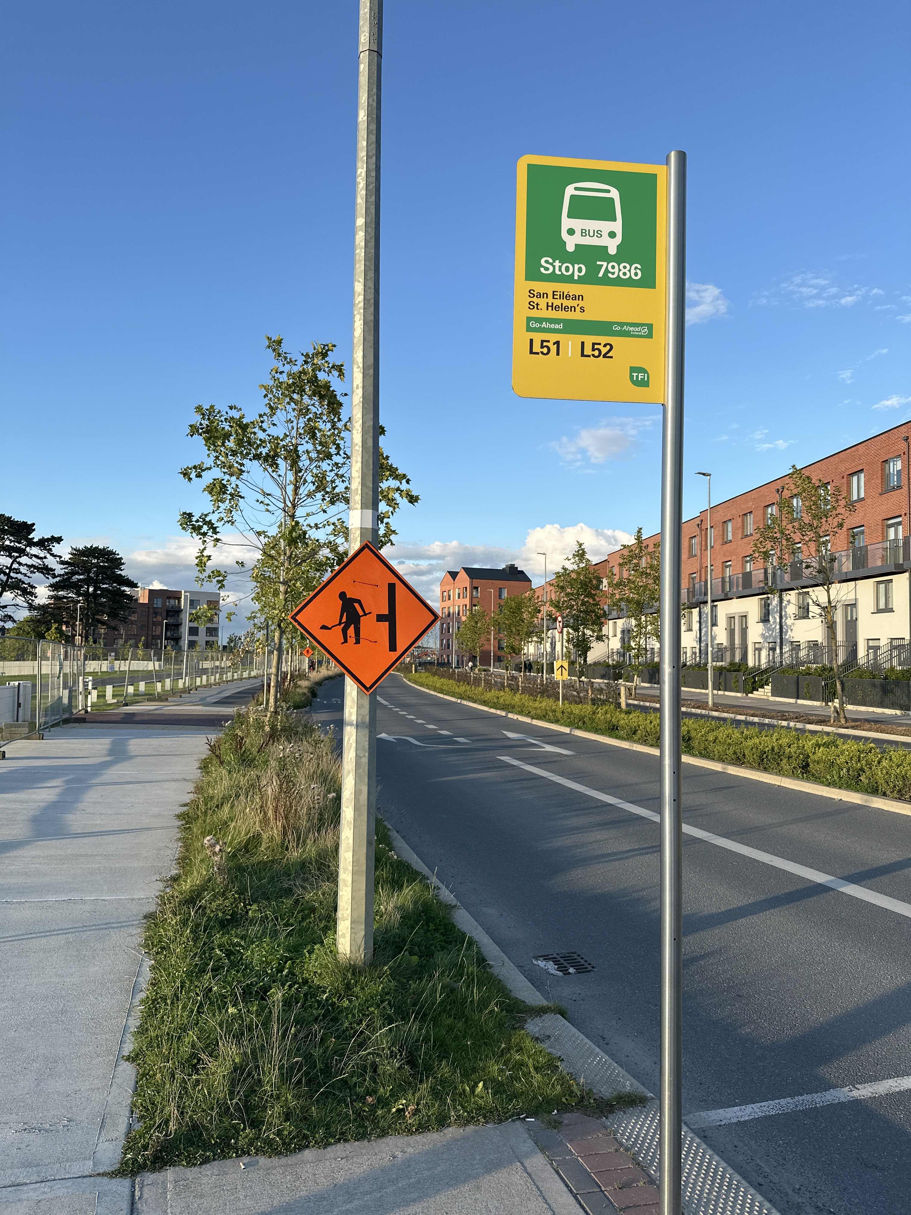
St. Helen's stop’s code is 7986
The first line to this stop is L51, at 7:52 AM, and the last line is L52 at 11:26 PM.
This stop serves Go-Ahead Ireland’s lines
- Shackleton Point,
- The Paddocks Drive,
- Shackleton Drive
Bus stops near St. Helen's stop
- Adamstown,
- Leixlip(Confey)
Train stations near St. Helen's station
- Innisfallen Parade,
- Blackpool Sc,
- Clare Street,
- Ashleigh Grove Galway,
- Bluepool Pitches,
- Meelick Roundabout,
- Brinny,
- Ardkeen Rtl Pk,
- Farmers Cross,
- Horizon Logis Pk,
- Blanchardstown N3,
- Maple Avenue,
- Clontarf Cstl,
- Father Sexton Pk,
- Orchard Road,
- Myrtleville,
- Douglas East,
- Watling Street,
- Clonskeagh,
- Muckross Avenue
Popular public transit stations in Lucan-St. Helen'S
Get around Lucan-St. Helen'S by public transit!
Traveling around Lucan-St. Helen'S has never been so easy. See step by step directions as you travel to any attraction, street or major public transit station. View bus and train schedules, arrival times, service alerts and detailed routes on a map, so you know exactly how to get to anywhere in Lucan-St. Helen'S.
When traveling to any destination around Lucan-St. Helen'S use Moovit's Live Directions with Get Off Notifications to know exactly where and how far to walk, how long to wait for your line, and how many stops are left. Moovit will alert you when it's time to get off — no need to constantly re-check whether yours is the next stop.
Wondering how to use public transit in Lucan-St. Helen'S or how to pay for public transit in Lucan-St. Helen'S? Moovit public transit app can help you navigate your way with public transit easily, and at minimum cost. It includes public transit fees, ticket prices, and costs. Looking for a map of Lucan-St. Helen'S public transit lines? Moovit public transit app shows all public transit maps in Lucan-St. Helen'S with all Bus, Train and Light Rail routes and stops on an interactive map.
Ireland has 3 transit type(s), including: Bus, Train and Light Rail, operated by several transit agencies, including Luas, Bus Átha Cliath – Dublin Bus, Bus Éireann, Go-Ahead Ireland, Nitelink, Dublin Bus, Citylink, City Direct, Kenneally's Bus Service, Aircoach, TFI Local Link Mayo, Irish Rail, Express Bus, JJ/Bernard Kavanagh, Dublin Coach and Kearns Transport