Directions to Steve Williams Insurance (Baltimore) with public transportation
The following transit lines have routes that pass near Steve Williams Insurance
 Bus: 80, CITYLINK LIME, 82.
- Metro: METRO.
How to get to Steve Williams Insurance by bus?
Click on the bus route to see step by step directions with maps, line arrival times and updated time schedules.
From Social Security Administration, Baltimore
28 minFrom Guinness Open Gate Brewery & Barrel House, Baltimore County
87 minFrom Horseshoe Casino Baltimore, Baltimore
40 minFrom Canton, Baltimore
65 minFrom Towson, MD, Baltimore County
64 minFrom Hilton Baltimore, Baltimore
35 minFrom Johns Hopkins Medicine at Green Spring Station, Baltimore County
60 minFrom Randallstown, MD, Baltimore County
36 minFrom Walters Art Museum, Baltimore
35 minFrom Towson Town Center, Baltimore County
59 min
How to get to Steve Williams Insurance by metro?
Click on the metro route to see step by step directions with maps, line arrival times and updated time schedules.
Bus stops near Steve Williams Insurance in Baltimore
Metro station near Steve Williams Insurance in Baltimore
- Penn North Metro, 17 min walk,VIEW
Light Rail stations near Steve Williams Insurance in Baltimore
- Woodberry, 21 min walk,VIEW
What are the closest stations to Steve Williams Insurance?
The closest stations to Steve Williams Insurance are:
- Garrison Blvd & Edgewood St Nb is 57 yards away, 1 min walk.
- Hilton St & Powhatan Ave FS Nb is 469 yards away, 6 min walk.
- Penn North Metro is 1378 yards away, 17 min walk.
- Woodberry is 1728 yards away, 21 min walk.
Which bus lines stop near Steve Williams Insurance?
These bus lines stop near Steve Williams Insurance: 80, CITYLINK LIME.
Which metro line stops near Steve Williams Insurance?
METRO (Towards Owing Mills)
What’s the nearest light rail station to Steve Williams Insurance in Baltimore?
The nearest light rail station to Steve Williams Insurance in Baltimore is Woodberry. It’s a 21 min walk away.
What’s the nearest metro station to Steve Williams Insurance in Baltimore?
The nearest metro station to Steve Williams Insurance in Baltimore is Penn North Metro. It’s a 17 min walk away.
What’s the nearest bus station to Steve Williams Insurance in Baltimore?
The nearest bus station to Steve Williams Insurance in Baltimore is Garrison Blvd & Edgewood St Nb. It’s a 1 min walk away.
What time is the first light rail to Steve Williams Insurance in Baltimore?
The LIGHT RAILLINK is the first light rail that goes to Steve Williams Insurance in Baltimore. It stops nearby at 4:26 AM.
What time is the last light rail to Steve Williams Insurance in Baltimore?
The LIGHT RAILLINK is the last light rail that goes to Steve Williams Insurance in Baltimore. It stops nearby at 12:47 AM.
What time is the first metro to Steve Williams Insurance in Baltimore?
The METRO is the first metro that goes to Steve Williams Insurance in Baltimore. It stops nearby at 4:56 AM.
What time is the last metro to Steve Williams Insurance in Baltimore?
The METRO is the last metro that goes to Steve Williams Insurance in Baltimore. It stops nearby at 12:19 AM.
What time is the first bus to Steve Williams Insurance in Baltimore?
The 80 is the first bus that goes to Steve Williams Insurance in Baltimore. It stops nearby at 3:06 AM.
What time is the last bus to Steve Williams Insurance in Baltimore?
The 80 is the last bus that goes to Steve Williams Insurance in Baltimore. It stops nearby at 3:15 AM.
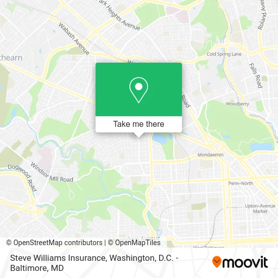
See Steve Williams Insurance, Baltimore, on the map
Public Transit to Steve Williams Insurance in Baltimore
Wondering how to get to Steve Williams Insurance in Baltimore? Moovit helps you find the best way to get to Steve Williams Insurance with step-by-step directions from the nearest public transit station.
Moovit provides free maps and live directions to help you navigate through your city. View schedules, routes, timetables, and find out how long does it take to get to Steve Williams Insurance in real time.
Looking for the nearest stop or station to Steve Williams Insurance? Check out this list of stops closest to your destination: Garrison Blvd & Edgewood St Nb; Hilton St & Powhatan Ave FS Nb; Penn North Metro; Woodberry.
Bus: 80, CITYLINK LIME, 82.Metro: METRO.
Want to see if there’s another route that gets you there at an earlier time? Moovit helps you find alternative routes or times. Get directions from and directions to Steve Williams Insurance easily from the Moovit App or Website.
We make riding to Steve Williams Insurance easy, which is why over 1.5 million users, including users in Baltimore, trust Moovit as the best app for public transit. You don’t need to download an individual bus app or train app, Moovit is your all-in-one transit app that helps you find the best bus time or train time available.
For information on prices of bus, metro and train, costs and ride fares to Steve Williams Insurance, please check the Moovit app.
Use the app to navigate to popular places including to the airport, hospital, stadium, grocery store, mall, coffee shop, school, college, and university.
Steve Williams Insurance Address: 3414 Duvall Ave street in Baltimore
- Ultimate Beauty Hair Salon,
- All in One Locksmith Shop,
- Garrison Blvd & Duvall St SB,
- East Coast Plumbers,
- Nevaeh's Beauty Salon & Boutique,
- Bmore Fashions,
- Lockdown Bail Bond & Insurance,
- Old Time Way,
- Ljj International Co,,
- Quality Moving and Hauling,
- First Corinthians Baptist Church,
- B & B Food Market,
- Purple Gorillaz,
- Belvedere Assistant Living,
- Forest Park Congregation of Jehovah's Witnesses,
- Exquisite Affairs Decor,
- Garwyn Oaks, Maryland,
- Al's & Willie's Trash / Junk Removal,
- Saunders Monroe R Rev,
- Baltimore Blossoms Studio
Places Near Steve Williams Insurance (Baltimore)
- Washington National Cathedral, Washington,
- Amazon Hq2, Arlington County,
- Capital One Arena, Washington,
- Camden Yards, Baltimore,
- M&T Bank Stadium, Baltimore,
- National Zoo, Washington,
- National Museum of African American History and Culture, Washington,
- Warner Theatre, Washington,
- PG Mall, Prince George's County,
- Rock Creek Tennis Center, Washington,
- National Mall, Washington,
- Pennsylvania Ave NW (3rd st and pennsylvania), Washington,
- The Anthem, Washington,
- Museum Of The Bible, Washington,
- Marriott Marquis Washington, DC, Washington,
- Washington DC VA Medical Center, Washington,
- Westfield Montgomery Mall, Montgomery County,
- Basilica of the National Shrine, Washington,
- Sibley Memorial Hospital, Washington,
- Georgetown, Washington
How to get to popular places in Washington, D.C. - Baltimore, MD with public transit
Get around Baltimore by public transit!
Traveling around Baltimore has never been so easy. See step by step directions as you travel to any attraction, street or major public transit station. View bus and train schedules, arrival times, service alerts and detailed routes on a map, so you know exactly how to get to anywhere in Baltimore.
When traveling to any destination around Baltimore use Moovit's Live Directions with Get Off Notifications to know exactly where and how far to walk, how long to wait for your line, and how many stops are left. Moovit will alert you when it's time to get off — no need to constantly re-check whether yours is the next stop.
Wondering how to use public transit in Baltimore or how to pay for public transit in Baltimore? Moovit public transit app can help you navigate your way with public transit easily, and at minimum cost. It includes public transit fees, ticket prices, and costs. Looking for a map of Baltimore public transit lines? Moovit public transit app shows all public transit maps in Baltimore with all Bus, Train, Metro, Light Rail and Ferry routes and stops on an interactive map.
Washington, D.C. - Baltimore, MD has 5 transit type(s), including: Bus, Train, Metro, Light Rail and Ferry, operated by several transit agencies, including WMATA, Montgomery County Ride On, Fairfax Connector, TheBus, PRTC, DASH - Alexandria, Arlington Transit (ART), RTA of Central Maryland, MDOT MTA, MDOT MTA Light RailLink, MDOT MTA Commuter Bus, MDOT MTA Local Bus, FXBGO!, Virginia Railway Express (VRE) and MARC