T-Mobile stop - Monday schedule
| Line | Direction | Time |
|---|---|---|
| DLOOP1 | City Of Doral Trolley (Rt. 1) | 6:51 AM |
| DLOOP1 | City Of Doral Trolley (Rt. 1) | 7:22 AM |
| DLOOP1 | City Of Doral Trolley (Rt. 1) | 7:50 AM |
| DLOOP1 | City Of Doral Trolley (Rt. 1) | 8:21 AM |
| DLOOP1 | City Of Doral Trolley (Rt. 1) | 8:54 AM |
| DLOOP1 | City Of Doral Trolley (Rt. 1) | 9:26 AM |
| DLOOP1 | City Of Doral Trolley (Rt. 1) | 9:59 AM |
| DLOOP1 | City Of Doral Trolley (Rt. 1) | 10:31 AM |
| DLOOP1 | City Of Doral Trolley (Rt. 1) | 11:03 AM |
| DLOOP1 | City Of Doral Trolley (Rt. 1) | 11:35 AM |
| DLOOP1 | City Of Doral Trolley (Rt. 1) | 12:01 PM |
| DLOOP1 | City Of Doral Trolley (Rt. 1) | 12:34 PM |
| DLOOP1 | City Of Doral Trolley (Rt. 1) | 1:06 PM |
| DLOOP1 | City Of Doral Trolley (Rt. 1) | 1:38 PM |
| DLOOP1 | City Of Doral Trolley (Rt. 1) | 2:07 PM |
| DLOOP1 | City Of Doral Trolley (Rt. 1) | 2:36 PM |
| DLOOP1 | City Of Doral Trolley (Rt. 1) | 3:24 PM |
| DLOOP1 | City Of Doral Trolley (Rt. 1) | 3:40 PM |
| DLOOP1 | City Of Doral Trolley (Rt. 1) | 3:55 PM |
| DLOOP1 | City Of Doral Trolley (Rt. 1) | 4:31 PM |
| DLOOP1 | City Of Doral Trolley (Rt. 1) | 4:58 PM |
| DLOOP1 | City Of Doral Trolley (Rt. 1) | 5:21 PM |
| DLOOP1 | City Of Doral Trolley (Rt. 1) | 5:45 PM |
| DLOOP1 | City Of Doral Trolley (Rt. 1) | 6:20 PM |
| DLOOP1 | City Of Doral Trolley (Rt. 1) | 6:54 PM |
Directions to T-Mobile stop (North Westside) with public transit
The following transit lines have routes that pass near T-Mobile
 Bus: 87, HIAMAR, 7, DLOOP1.
How to get to T-Mobile stop by bus?
Click on the bus route to see step by step directions with maps, line arrival times and updated time schedules.
Bus stops near T-Mobile stop in North Westside
- Nw 87 Av @ Nw 13 Tr, 3 min walk,
- Nw 87 Av & Nw 7 St, 12 min walk,
- Red Lobster, 14 min walk,
- Nw87 Ave@nw13ter, 21 min walk,
Bus lines to T-Mobile stop in North Westside
- 87, 87 - Dadeland North Station,
- 7, 7 - Downtown Miami,
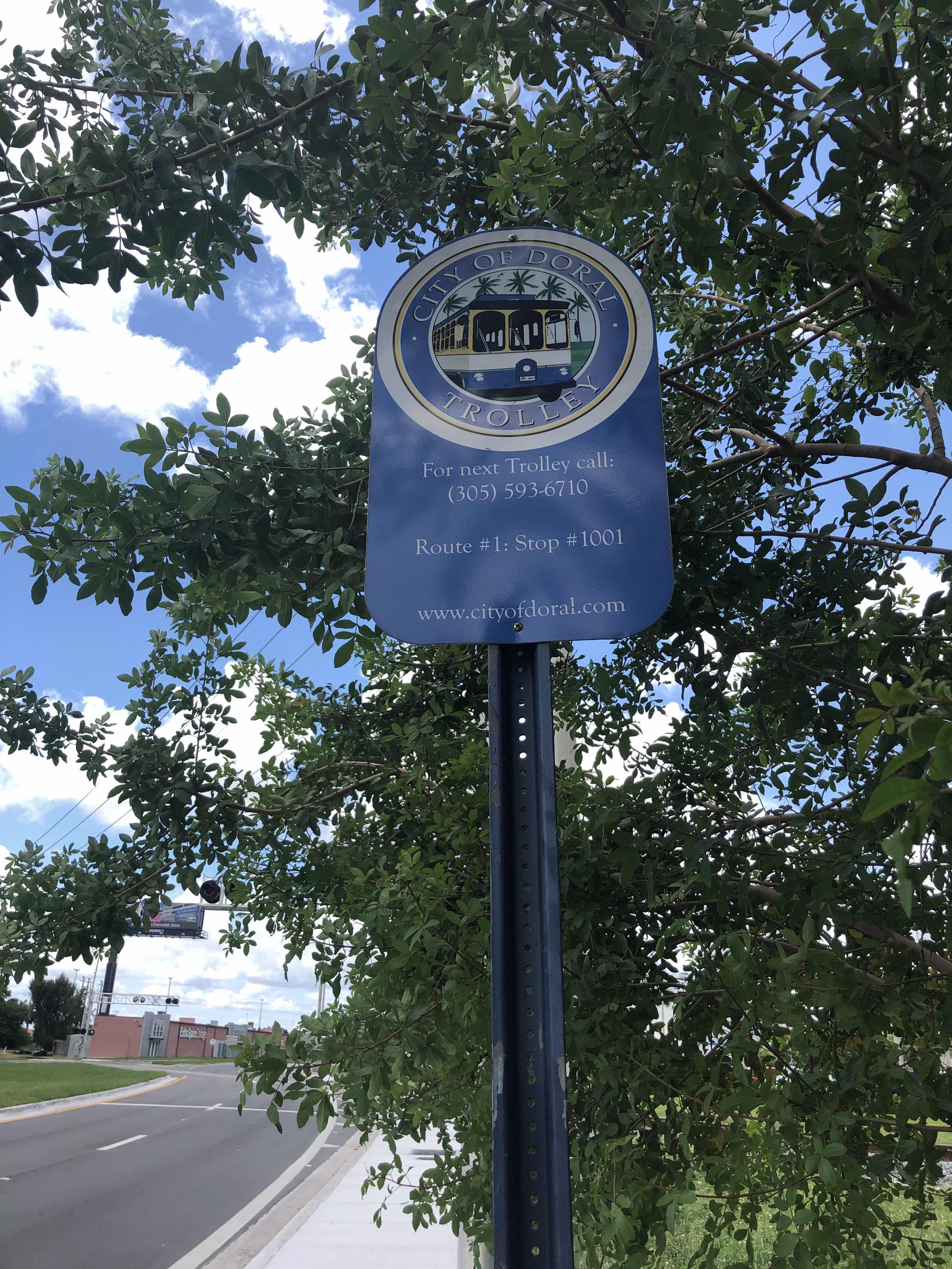
- DLOOP1, City Of Doral Trolley (Rt. 1),
- HIAMAR, City Of Hialeah Transit (Marlin),
What are the closest stations to T-Mobile?
The closest stations to T-Mobile are:
- Nw 87 Av @ Nw 13 Tr stop is 179 yards away, 3 min walk.
- Nw 87 Av & Nw 7 St stop is 1017 yards away, 12 min walk.
- Red Lobster stop is 1087 yards away, 14 min walk.
- Nw87 Ave@nw13ter stop is 1749 yards away, 21 min walk.
Which bus lines stop near T-Mobile?
These bus lines stop near T-Mobile: 87, HIAMAR.
What’s the nearest bus station to T-Mobile in North Westside?
The nearest bus station to T-Mobile in North Westside is Nw 87 Av @ Nw 13 Tr. It’s a 3 min walk away.
What time is the first bus to T-Mobile in North Westside?
The 7 is the first bus that goes to T-Mobile in North Westside. It stops nearby at 5:05 AM.
What time is the last bus to T-Mobile in North Westside?
The 7 is the last bus that goes to T-Mobile in North Westside. It stops nearby at 12:12 AM.
T-Mobile station
 Taken by Anonymous
See T-Mobile stop, North Westside, on the map
Public transit to T-Mobile stop (ID: DORLP101) in North Westside
Looking for directions to T-Mobile in North Westside, United States?
Download the Moovit App to find the current schedule and step-by-step directions for Bus or Train routes that pass through T-Mobile.
Looking for the nearest stops closest to T-Mobile ? Check out this list of closest stops to your destination: Nw 87 Av @ Nw 13 Tr; Nw 87 Av & Nw 7 St; Red Lobster; Nw87 Ave@nw13ter.
Bus: 87, HIAMAR, 7, DLOOP1.
We make riding on public transit to T-Mobile easy, which is why over 1.7 billion users, including users in North Westside trust Moovit as the best app for public transit.
Use the app to navigate to popular places including to the airport, hospital, stadium, grocery store, mall, coffee shop, school, college, and university.
T-Mobile stop’s code is DORLP101
The first line to this stop is DLOOP1, at 6:51 AM, and the last line is DLOOP1 at 10:00 PM.
1200 Nw 87th Ave, Sweetwater, FL, USA
This stop serves Miami-Dade Transit’s lines
Popular routes from T-Mobile stop, North Westside
- Nw 87 Av @ Nw 13 Tr,
- Nw 87 Av & Nw 7 St,
- Red Lobster,
- Nw87 Ave@nw13ter
Bus stops near T-Mobile stop
- Nw 36 St @ Nw 72 Av,
- W Flagler St & Sw 40 Av,
- AUSTRALIAN AVE at 25TH ST,
- Sunrise Lakes Boulevard/Pine Island Road,
- CONGRESS AVE at MELALEUCA RD,
- Fiu Univ Campus@Sw 107 Av-17 St,
- WPB ITC at BAY N,
- MILITARY TRL at OKEECHOBEE BLVD,
- Nw 27 Av & Opa Locka Bd,
- Se 8 Av & Okeechobee Rd,
- Nw 12 Av & 183 St,
- Nw 17 Av & 36 St,
- Sw 137 Av @ Sw 104 St,
- Nw 32 Av & 103 St,
- Sw 40 St @ Sw 99 Av,
- Sw 104 St & Sw 147 Av,
- Sw 167 Av @ Sw 292 St,
- Ne 172 St & W Dixie Hwy,
- Nw 167 St & Nw 12 Av,
- Sw 88 St & 89 Ct
Popular public transit stations in North Westside
Get around North Westside by public transit!
Traveling around North Westside has never been so easy. See step by step directions as you travel to any attraction, street or major public transit station. View bus and train schedules, arrival times, service alerts and detailed routes on a map, so you know exactly how to get to anywhere in North Westside.
When traveling to any destination around North Westside use Moovit's Live Directions with Get Off Notifications to know exactly where and how far to walk, how long to wait for your line, and how many stops are left. Moovit will alert you when it's time to get off — no need to constantly re-check whether yours is the next stop.
Wondering how to use public transit in North Westside or how to pay for public transit in North Westside? Moovit public transit app can help you navigate your way with public transit easily, and at minimum cost. It includes public transit fees, ticket prices, and costs. Looking for a map of North Westside public transit lines? Moovit public transit app shows all public transit maps in North Westside with all Bus, Train, Light Rail and Ferry routes and stops on an interactive map.
Miami has 4 transit type(s), including: Bus, Train, Light Rail and Ferry, operated by several transit agencies, including Broward County Transit, Miami-Dade Transit, Metrorail, Palm Tran, Tri-Rail, Brightline, MARTY, City of Homestead Trolley, Key West Transit, Treasure Coast Connector, GoLine IRT, Amtrak, Greyhound-us, FlixBus-us and Aventura Express Shuttle Bus