How to get to Target Als by bus?
Click on the bus route to see step by step directions with maps, line arrival times and updated time schedules.
From Radio Hotel, Manhattan
66 minFrom 1 Bowling Grn, Manhattan
65 minFrom Middle Village, NY, Queens
59 minFrom Orchard St, Manhattan
48 minFrom Jackson Heights, NY, Queens
73 minFrom Tenement Museum, Manhattan
49 minFrom Queens Center Mall, Queens
42 minFrom George Washington Bridge Bus Station, Manhattan
60 min
How to get to Target Als by train?
Click on the train route to see step by step directions with maps, line arrival times and updated time schedules.
How to get to Target Als by subway?
Click on the subway route to see step by step directions with maps, line arrival times and updated time schedules.
From Radio Hotel, Manhattan
37 minFrom 1 Bowling Grn, Manhattan
31 minFrom Middle Village, NY, Queens
62 minFrom Orchard St, Manhattan
23 minFrom Jackson Heights, NY, Queens
35 minFrom Tenement Museum, Manhattan
24 minFrom Queens Center Mall, Queens
35 minFrom George Washington Bridge Bus Station, Manhattan
28 min
Bus stops near Target Als in Manhattan
Subway stations near Target Als in Manhattan
Bus lines to Target Als in Manhattan
- 59TH ST, Midtown / W 39th Street,VIEW
- M20, Lincoln Center 66 St Via 8 Av,VIEW
- M104, 41 St Via Broadway/7 Av,VIEW
- M31, Yorkville 91 St Via York Av,VIEW
- M57, West Side Broadway-72 St Crosstown,VIEW
- M10, Harlem 159 St Via 8 Av,VIEW
- M12, West Village Abingdon Sq,VIEW
- 57TH ST, Midtown / W 39th Street,VIEW
- HAMPTON JITNEY MONTAUK, Amagansett,VIEW
- BXM2, West Midtown Penn Sta-34 St Via Kappock St,VIEW
- M7, 14 St Via Columbus Via 7 Av,VIEW
- W44, Midtown / W 39th Street,VIEW
What are the closest stations to Target Als?
The closest stations to Target Als are:
- 8th Ave & W 56th St is 116 yards away, 2 min walk.
- 8 Av/W 56 St is 125 yards away, 2 min walk.
- W 57 St/8 Av is 185 yards away, 3 min walk.
- 8 Av/W 57 St is 189 yards away, 3 min walk.
- W 57th St & 8th Ave is 208 yards away, 3 min walk.
- 55th St & 7th Westsider is 248 yards away, 4 min walk.
- 7 Av/W 57 St is 267 yards away, 4 min walk.
- 57 St-7 Av is 267 yards away, 4 min walk.
- 7 Av/W 55 St is 315 yards away, 4 min walk.
- 50 St is 407 yards away, 5 min walk.
- 59 St-Columbus Circle is 748 yards away, 9 min walk.
- 57 St is 752 yards away, 9 min walk.
- 7 Av is 774 yards away, 10 min walk.
Which bus lines stop near Target Als?
These bus lines stop near Target Als: 57TH ST, M20, M31, M5, M57, QM12, QM24.
Which train lines stop near Target Als?
These train lines stop near Target Als: FAR ROCKAWAY BRANCH, YEL.
Which subway lines stop near Target Als?
These subway lines stop near Target Als: 1, A, B, E, M, Q, R.
What’s the nearest subway station to Target Als in Manhattan?
The nearest subway station to Target Als in Manhattan is 57 St-7 Av. It’s a 4 min walk away.
What’s the nearest bus station to Target Als in Manhattan?
The nearest bus stations to Target Als in Manhattan are 8th Ave & W 56th St and 8 Av/W 56 St. The closest one is a 2 min walk away.
What time is the first subway to Target Als in Manhattan?
The D is the first subway that goes to Target Als in Manhattan. It stops nearby at 3:00 AM.
What time is the last subway to Target Als in Manhattan?
The N is the last subway that goes to Target Als in Manhattan. It stops nearby at 4:03 AM.
What time is the first bus to Target Als in Manhattan?
The M104 is the first bus that goes to Target Als in Manhattan. It stops nearby at 3:04 AM.
What time is the last bus to Target Als in Manhattan?
The M7 is the last bus that goes to Target Als in Manhattan. It stops nearby at 3:08 AM.
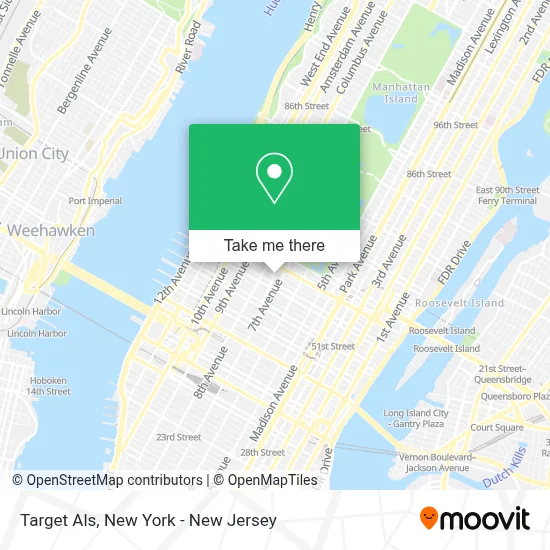
See Target Als, Manhattan, on the map
Public Transit to Target Als in Manhattan
Wondering how to get to Target Als in Manhattan? Moovit helps you find the best way to get to Target Als with step-by-step directions from the nearest public transit station.
Moovit provides free maps and live directions to help you navigate through your city. View schedules, routes, timetables, and find out how long does it take to get to Target Als in real time.
Looking for the nearest stop or station to Target Als? Check out this list of stops closest to your destination: 8th Ave & W 56th St; 8 Av/W 56 St; W 57 St/8 Av; 8 Av/W 57 St; W 57th St & 8th Ave; 55th St & 7th Westsider; 7 Av/W 57 St; 57 St-7 Av; 7 Av/W 55 St; 50 St; 59 St-Columbus Circle; 57 St; 7 Av.
Bus: 57TH ST, M20, M31, M5, M57, QM12, QM24, 59TH ST.Train: FAR ROCKAWAY BRANCH, YEL.Subway: 1, A, B, E, M, Q, R, N, W, 2, C, D, F.
Want to see if there’s another route that gets you there at an earlier time? Moovit helps you find alternative routes or times. Get directions from and directions to Target Als easily from the Moovit App or Website.
We make riding to Target Als easy, which is why over 1.5 million users, including users in Manhattan, trust Moovit as the best app for public transit. You don’t need to download an individual bus app or train app, Moovit is your all-in-one transit app that helps you find the best bus time or train time available.
For information on prices of subway, bus and train, costs and ride fares to Target Als, please check the Moovit app.
Use the app to navigate to popular places including to the airport, hospital, stadium, grocery store, mall, coffee shop, school, college, and university.
Target Als Address: 1740 Broadway street in Manhattan
- Orsid Realty,
- Cmit Solutions,
- The Vl Studios,
- Vandalay Media,
- Serafina Restaurant Group,
- Omnycode,
- Victoria's Secret Beauty,
- Matrix Ht,
- Bluescope Technologies Inc,
- Revchain Llc,
- Photosesh,
- Your Magazine Nyc,
- Omni Law P.C.,
- Omni Injury and Accident Law, P.C.,
- Eberly & Collard Public Relations,
- Omnycode,
- Omni Law P.C.,
- Seismicps | Seismic Protection Solutions, Llc,
- Photosesh,
- 1790Manhattan
Places Near Target Als (Manhattan)
- Wall Street, Manhattan,
- 111 Centre New York City Supreme Court, Manhattan,
- Katz's Deli, Manhattan,
- Hudson Yards, Manhattan,
- qqqq, Manhattan,
- Chinatown, Manhattan,
- 3 Stone St, Manhattan,
- SoHo, Manhattan,
- 376 Hudson Street, Manhattan,
- San Gennaro Feast, Manhattan,
- Pier 83, Manhattan,
- Bellevue Hospital, Manhattan,
- 26 Federal Plaza, Manhattan,
- Queens Center Mall, Queens,
- Times Square, Manhattan,
- 911 Memorial, Manhattan,
- 66 John Street, Manhattan,
- Rockefeller Center, Manhattan,
- Mountainside Hospital, Glen Ridge,
- 1 Police Plaza, Manhattan
How to get to popular places in New York - New Jersey with public transit
Get around Manhattan by public transit!
Traveling around Manhattan has never been so easy. See step by step directions as you travel to any attraction, street or major public transit station. View bus and train schedules, arrival times, service alerts and detailed routes on a map, so you know exactly how to get to anywhere in Manhattan.
When traveling to any destination around Manhattan use Moovit's Live Directions with Get Off Notifications to know exactly where and how far to walk, how long to wait for your line, and how many stops are left. Moovit will alert you when it's time to get off — no need to constantly re-check whether yours is the next stop.
Wondering how to use public transit in Manhattan or how to pay for public transit in Manhattan? Moovit public transit app can help you navigate your way with public transit easily, and at minimum cost. It includes public transit fees, ticket prices, and costs. Looking for a map of Manhattan public transit lines? Moovit public transit app shows all public transit maps in Manhattan with all Bus, Train, Subway, Light Rail, Ferry and Cable Car routes and stops on an interactive map.
New York - New Jersey has 6 transit type(s), including: Bus, Train, Subway, Light Rail, Ferry and Cable Car, operated by several transit agencies, including MTA Subway, Metro-North Railroad, LIRR, PATH, MTA New York City Transit - Express routes, MTA Bus, NJ Transit, NYC Ferry, NICE bus, Bee-Line Bus, NJ Transit Rail, Norwalk Transit District, Hartford Line, River Valley Transit and HART