Telémaco
-
-
-
-
-
-
-
-
-
-
Directions to Telémaco stop (Madrid) with public transit
The following transit lines have routes that pass near Telémaco
 Bus: 114, 115, 146, 21, 70.
- Metro: M-4, M-5, M-7.
How to get to Telémaco stop by bus?
Click on the bus route to see step by step directions with maps, line arrival times and updated time schedules.
How to get to Telémaco stop by metro?
Click on the metro route to see step by step directions with maps, line arrival times and updated time schedules.
Bus stops near Telémaco stop in Madrid
- Josefa Valcárcel, 4 min walk,
- Marqués De Portugalete, 6 min walk,
- Juan Ignacio Luca De Tena - Alegría Oria, 7 min walk,
- Arturo Soria - Marqués De Pico Velasco, 7 min walk,
- Avenida De América - Conde De Orgaz, 18 min walk,
Metro stations near Telémaco station in Madrid
- Barrio De La Concepción, 4 min walk,
- Pueblo Nuevo, 11 min walk,
- Esperanza, 14 min walk,
Bus lines to Telémaco stop in Madrid
- 114, Avenida de America - Barrio del Aeropuerto,
- 115, Avenida de America - Barajas,
- N4, Plaza de Cibeles - Barajas,
- 21, El Salvador,
- 146, Los Molinos,
- 70, Alsacia,
- 222, Madrid (Avda. América) - Meco,
- 223, Madrid (Avda. América) - Alcalá de Henares,
- 224, Madrid (Avda. América) - Torrejón de Ardoz,
- 226, Madrid (Avda. América) - Torrejón de Ardoz (El Soto),
- 227, Madrid (Avda. América) - Alcalá (Espartales - Universidad),
- 229, Madrid (Avda. América) - Alcalá (Virgen del Val),
- 282, Madrid (Avda. América) - San Fernando - Mejorada,
- 283, Madrid (Avda. América) - Coslada - San Fernando,
- 224A, Madrid (Avda. América) - Torrejón de Ardoz (La Mancha Amarilla),
- N202, Madrid (Avda. América) - Torrejón - Alcalá - Meco,
- VAC243, Madrid (Avda. América) - Guadalajara,
What are the closest stations to Telémaco?
The closest stations to Telémaco are:
- Josefa Valcárcel is 263 meters away, 4 min walk.
- Barrio De La Concepción is 293 meters away, 4 min walk.
- Marqués De Portugalete is 430 meters away, 6 min walk.
- Juan Ignacio Luca De Tena - Alegría Oria is 516 meters away, 7 min walk.
- Arturo Soria - Marqués De Pico Velasco is 545 meters away, 7 min walk.
- Pueblo Nuevo is 824 meters away, 11 min walk.
- Esperanza is 1105 meters away, 14 min walk.
- Avenida De América - Conde De Orgaz is 1362 meters away, 18 min walk.
Which bus lines stop near Telémaco?
These bus lines stop near Telémaco: 114, 115, 146, 21, 70.
Which metro lines stop near Telémaco?
These metro lines stop near Telémaco: M-4, M-5.
What’s the nearest metro station to Telémaco in Madrid?
The nearest metro station to Telémaco in Madrid is Barrio De La Concepción. It’s a 4 min walk away.
What’s the nearest bus station to Telémaco in Madrid?
The nearest bus station to Telémaco in Madrid is Josefa Valcárcel. It’s a 4 min walk away.
What time is the first metro to Telémaco in Madrid?
The M-5 is the first metro that goes to Telémaco in Madrid. It stops nearby at 6:05 AM.
What time is the last metro to Telémaco in Madrid?
The M-5 is the last metro that goes to Telémaco in Madrid. It stops nearby at 2:17 AM.
What time is the first bus to Telémaco in Madrid?
The N4 is the first bus that goes to Telémaco in Madrid. It stops nearby at 3:05 AM.
What time is the last bus to Telémaco in Madrid?
The N4 is the last bus that goes to Telémaco in Madrid. It stops nearby at 3:14 AM.
Telémaco station
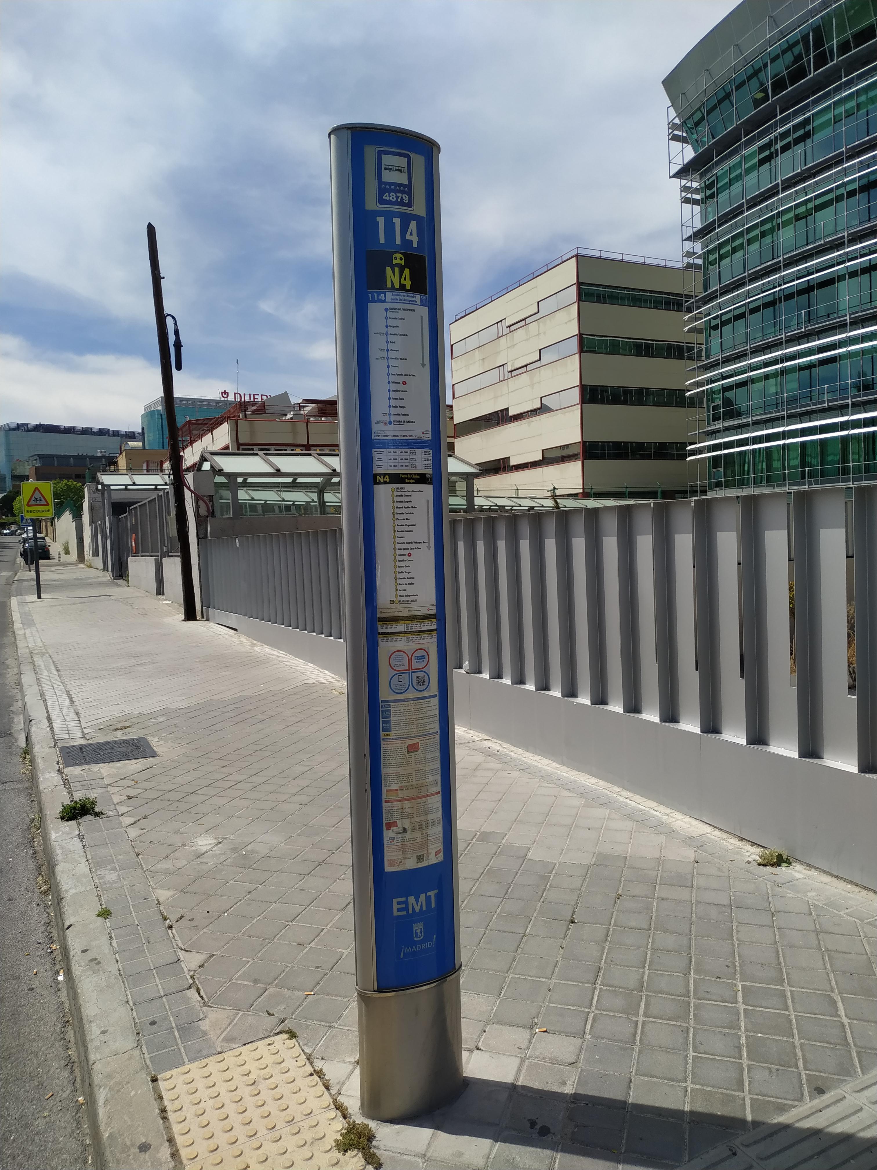 Taken by Pitter F.
See Telémaco stop, Madrid, on the map
Public transit to Telémaco stop (ID: 4879) in Madrid
Looking for directions to Telémaco in Madrid, Spain?
Download the Moovit App to find the current schedule and step-by-step directions for Bus or Metro routes that pass through Telémaco.
Looking for the nearest stops closest to Telémaco ? Check out this list of closest stops to your destination: Josefa Valcárcel; Barrio De La Concepción; Marqués De Portugalete; Juan Ignacio Luca De Tena - Alegría Oria; Arturo Soria - Marqués De Pico Velasco; Pueblo Nuevo; Esperanza; Avenida De América - Conde De Orgaz.
Bus: 114, 115, 146, 21, 70, N4.Metro: M-4, M-5, M-7.
We make riding on public transit to Telémaco easy, which is why over 1.5 million users, including users in Madrid trust Moovit as the best app for public transit.
Use the app to navigate to popular places including to the airport, hospital, stadium, grocery store, mall, coffee shop, school, college, and university.
Telémaco stop’s code is 4879
The first line to this stop is N4, at 5:23 AM, and the last line is N4 at 4:51 AM.
Calle Telémaco, Madrid, Spain
This stop serves Renfe Cercanías and EMT’s lines
Live Arrivals for Telémaco stop
See real-time arrivals at Telémaco stop, similar to an information board at stop itself. Check arrival times with live updates, delays, and service information. If you use this stop often or want to check arrival times in advance, we recommend saving this page.
- Josefa Valcárcel,
- Marqués De Portugalete,
- Juan Ignacio Luca De Tena - Alegría Oria,
- Arturo Soria - Marqués De Pico Velasco,
- Avenida De América - Conde De Orgaz
Bus stops near Telémaco stop
- Barrio De La Concepción,
- Pueblo Nuevo,
- Esperanza
Metro stations near Telémaco station
- Mar De Cristal,
- Colón,
- Ventura Rodríguez,
- Peñagrande,
- Atocha,
- Terminal Pza. España - Est. Torrejón,
- Juan Herrera,
- Metro Sainz De Baranda,
- Embajadores,
- Hospital 12 De Octubre,
- Sainz De Baranda,
- La Granja,
- Polígono Industrial Vicálvaro,
- Pirámides,
- Mariano De Cavia,
- Camino Fuente De La Mora,
- Hospital De La Princesa,
- Alonso De Mendoza,
- Delicias - Atocha,
- Tres Olivos
Popular public transit stations in Madrid
Get around Madrid by public transit!
Traveling around Madrid has never been so easy. See step by step directions as you travel to any attraction, street or major public transit station. View bus and train schedules, arrival times, service alerts and detailed routes on a map, so you know exactly how to get to anywhere in Madrid.
When traveling to any destination around Madrid use Moovit's Live Directions with Get Off Notifications to know exactly where and how far to walk, how long to wait for your line, and how many stops are left. Moovit will alert you when it's time to get off — no need to constantly re-check whether yours is the next stop.
Wondering how to use public transit in Madrid or how to pay for public transit in Madrid? Moovit public transit app can help you navigate your way with public transit easily, and at minimum cost. It includes public transit fees, ticket prices, and costs. Looking for a map of Madrid public transit lines? Moovit public transit app shows all public transit maps in Madrid with all Bus, Train, Metro and Light Rail routes and stops on an interactive map.
Madrid has 4 transit type(s), including: Bus, Train, Metro and Light Rail, operated by several transit agencies, including Metro de Madrid, Metro Ligero, Tranvía de Parla, Renfe Cercanías - Servicios de Autobús especiales, Renfe Cercanias, Renfe Cercanías, EMT, Interurbanos, Urbanos de Alcalá de Henares, Urbanos de Alcobendas, Urbanos de Alcorcón, Urbanos de Algete, Urbanos de Aranjuez, Urbanos de Arganda del Rey and Urbanos de Arroyomolinos