Terzi/Macchia Palocco stop - Wednesday schedule
| Line | Direction | Time |
|---|---|---|
| 03 | Altamura/Bertolla | 5:12 AM |
| 08 | Antifane/Isola 46 | 5:28 AM |
| 03 | Altamura/Bertolla | 5:31 AM |
| 03 | Altamura/Bertolla | 5:51 AM |
| 08 | Antifane/Isola 46 | 5:59 AM |
| 03 | Altamura/Bertolla | 6:10 AM |
| 03 | Altamura/Bertolla | 6:26 AM |
| 08 | Antifane/Isola 46 | 6:31 AM |
| 03 | Altamura/Bertolla | 6:40 AM |
| 03 | Altamura/Bertolla | 6:54 AM |
| 08 | Antifane/Isola 46 | 7:02 AM |
| 03 | Altamura/Bertolla | 7:09 AM |
| 03 | Altamura/Bertolla | 7:27 AM |
| 08 | Antifane/Isola 46 | 7:33 AM |
| 03 | Altamura/Bertolla | 7:43 AM |
| 03 | Altamura/Bertolla | 8:00 AM |
| 08 | Antifane/Isola 46 | 8:03 AM |
| 03 | Altamura/Bertolla | 8:17 AM |
| 03 | Altamura/Bertolla | 8:33 AM |
| 08 | Antifane/Isola 46 | 8:34 AM |
| 03 | Altamura/Bertolla | 8:50 AM |
| 08 | Antifane/Isola 46 | 9:05 AM |
| 03 | Altamura/Bertolla | 9:07 AM |
| 03 | Altamura/Bertolla | 9:23 AM |
| 08 | Antifane/Isola 46 | 9:35 AM |
Directions to Terzi/Macchia Palocco stop (Roma) with public transit
The following transit lines have routes that pass near Terzi/Macchia Palocco
 Bus: 03, 04, 08, 712.
- Train: FC2.
How to get to Terzi/Macchia Palocco stop by bus?
Click on the bus route to see step by step directions with maps, line arrival times and updated time schedules.
How to get to Terzi/Macchia Palocco stop by train?
Click on the train route to see step by step directions with maps, line arrival times and updated time schedules.
Bus stops near Terzi/Macchia Palocco stop in Roma
- Massaruti/Macchia Palocco, 4 min walk,
- Molteni/Arpe, 8 min walk,
Train stations near Terzi/Macchia Palocco station in Roma
- Casal Bernocchi-Centro Giano, 40 min walk,
Bus lines to Terzi/Macchia Palocco stop in Roma
- 03, Altamura/Bertolla,
- 08, Monti San Paolo/Conforti,
- 712, Eur Fermi (Metro B),
What are the closest stations to Terzi/Macchia Palocco?
The closest stations to Terzi/Macchia Palocco are:
- Massaruti/Macchia Palocco stop is 287 meters away, 4 min walk.
- Molteni/Arpe stop is 538 meters away, 8 min walk.
- Casal Bernocchi-Centro Giano station is 3176 meters away, 40 min walk.
Which bus lines stop near Terzi/Macchia Palocco?
These bus lines stop near Terzi/Macchia Palocco: 03, 04, 08, 712.
Which train line stops near Terzi/Macchia Palocco?
FC2 (Cristoforo Colombo)
What’s the nearest bus station to Terzi/Macchia Palocco in Roma?
The nearest bus station to Terzi/Macchia Palocco in Roma is Massaruti/Macchia Palocco. It’s a 4 min walk away.
What time is the first train to Terzi/Macchia Palocco in Roma?
The FC2 is the first train that goes to Terzi/Macchia Palocco in Roma. It stops nearby at 5:30 AM.
What time is the last train to Terzi/Macchia Palocco in Roma?
The FC2 is the last train that goes to Terzi/Macchia Palocco in Roma. It stops nearby at 9:22 PM.
What time is the first bus to Terzi/Macchia Palocco in Roma?
The 03 is the first bus that goes to Terzi/Macchia Palocco in Roma. It stops nearby at 5:01 AM.
What time is the last bus to Terzi/Macchia Palocco in Roma?
The 03 is the last bus that goes to Terzi/Macchia Palocco in Roma. It stops nearby at 12:36 AM.
Terzi/Macchia Palocco station
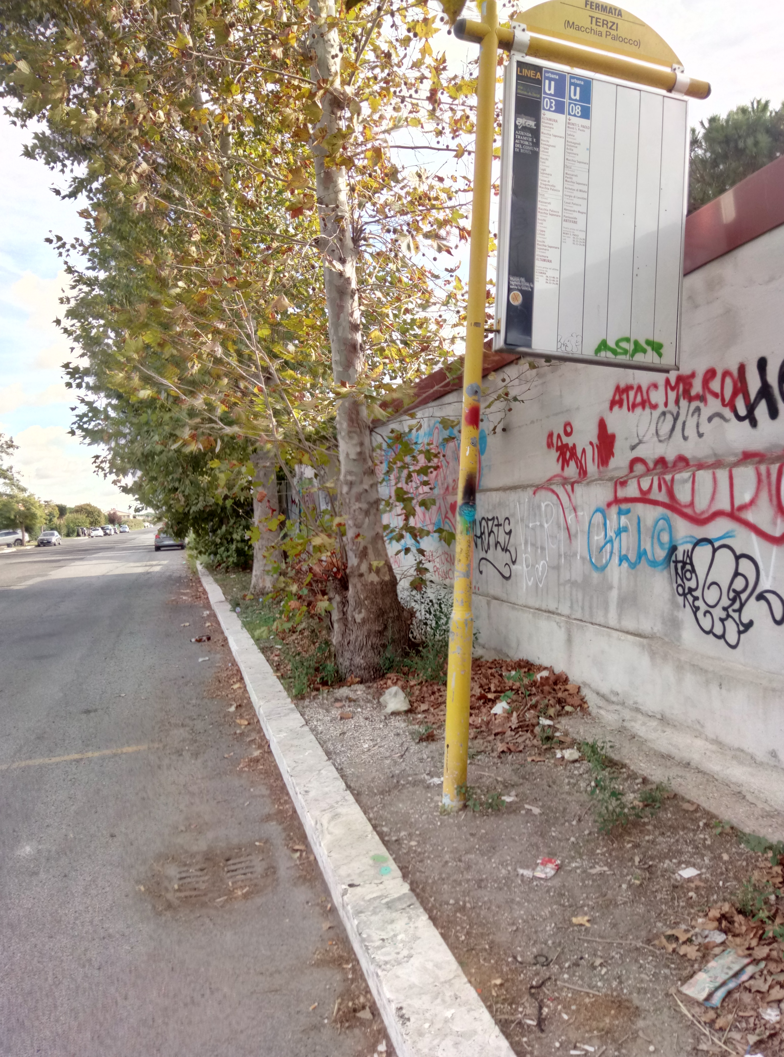 Taken by Anonymous
See Terzi/Macchia Palocco stop, Roma, on the map
Public transit to Terzi/Macchia Palocco stop (ID: 78933) in Roma
Looking for directions to Terzi/Macchia Palocco in Roma, Italy?
Download the Moovit App to find the current schedule and step-by-step directions for Bus, Train or Metro routes that pass through Terzi/Macchia Palocco.
Looking for the nearest stops closest to Terzi/Macchia Palocco ? Check out this list of closest stops to your destination: Massaruti/Macchia Palocco; Molteni/Arpe; Casal Bernocchi-Centro Giano.
Bus: 03, 04, 08, 712.Train: FC2.
We make riding on public transit to Terzi/Macchia Palocco easy, which is why over 1.7 billion users, including users in Roma trust Moovit as the best app for public transit.
Use the app to navigate to popular places including to the airport, hospital, stadium, grocery store, mall, coffee shop, school, college, and university.
Terzi/Macchia Palocco stop’s code is 78933
The first line to this stop is 03, at 5:12 AM, and the last line is 03 at 12:29 AM.
This stop serves BIS and ATAC’s lines
- Massaruti/Macchia Palocco,
- Molteni/Arpe
Bus stops near Terzi/Macchia Palocco stop
- Casal Bernocchi-Centro Giano
Train station near Terzi/Macchia Palocco station
- Balsamo Crivelli,
- Viterbo Porta Fiorentina,
- Albano | Trilussa Road Appia Road,
- Guido Carli,
- Cesano Di Roma,
- Vittorio Emanuele Course/Navona,
- Bracciano,
- Trivigliano | San Rocco Borough,
- Sports Fields (On Request),
- Magliano Romano (On Request),
- De Filippo/Pica,
- Independence Square,
- Boccea/Torrevecchia,
- Catanzaro,
- Tiburtina/Marrucini,
- Ladispoli, Florence Street 26,
- Portuense Road - Mercure Hotel,
- Celio Vibenna,
- Porta Portese,
- Tor Carbone/Ardeatina
Popular public transit stations in Roma
Get around Roma by public transit!
Traveling around Roma has never been so easy. See step by step directions as you travel to any attraction, street or major public transit station. View bus and train schedules, arrival times, service alerts and detailed routes on a map, so you know exactly how to get to anywhere in Roma.
When traveling to any destination around Roma use Moovit's Live Directions with Get Off Notifications to know exactly where and how far to walk, how long to wait for your line, and how many stops are left. Moovit will alert you when it's time to get off — no need to constantly re-check whether yours is the next stop.
Wondering how to use public transit in Roma or how to pay for public transit in Roma? Moovit public transit app can help you navigate your way with public transit easily, and at minimum cost. It includes public transit fees, ticket prices, and costs. Looking for a map of Roma public transit lines? Moovit public transit app shows all public transit maps in Roma with all Bus, Train, Metro, Light Rail, Ferry, Funicular and Gondola routes and stops on an interactive map.
Rome and Lazio has 7 transit type(s), including: Bus, Train, Metro, Light Rail, Ferry, Funicular and Gondola, operated by several transit agencies, including ATAC, Cotral, Trenitalia, Troiani Transportation Services, BIS, ATR Mobility, Tuscia, Shuttle, Seatour, Troiani Bus Lines, CSC Mobility, Terravision, ATRAL, Tambus and Sitbus