How to get to Trinity Services by bus?
Click on the bus route to see step by step directions with maps, line arrival times and updated time schedules.
From I-295 Exit 1 - Naval Research Lab, Washington
67 minFrom Washington Plaza Hotel, Washington
56 minFrom Charles E. Smith Center, Washington
55 minFrom Pentagon North Parking Lot, Arlington County
78 minFrom National Hall / Reagan National Airport (DCA), Arlington County
121 minFrom FBI - Washington Field Office, Washington
31 minFrom The John F. Kennedy Center for the Performing Arts, Washington
61 minFrom Ronald Reagan Washington National Airport (Dca), Arlington County
121 minFrom State Plaza Hotel, Washington
62 minFrom National Museum of the American Indian, Washington
41 min
How to get to Trinity Services by metro?
Click on the metro route to see step by step directions with maps, line arrival times and updated time schedules.
From National Museum of the American Indian, Washington
26 minFrom Washington Plaza Hotel, Washington
35 minFrom Charles E. Smith Center, Washington
36 minFrom Pentagon North Parking Lot, Arlington County
57 minFrom National Hall / Reagan National Airport (DCA), Arlington County
42 minFrom FBI - Washington Field Office, Washington
29 minFrom The John F. Kennedy Center for the Performing Arts, Washington
41 minFrom State Plaza Hotel, Washington
39 minFrom Ronald Reagan Washington National Airport (Dca), Arlington County
42 min
Bus stops near Trinity Services in Washington
Metro stations near Trinity Services in Washington
Bus lines to Trinity Services in Washington
What are the closest stations to Trinity Services?
The closest stations to Trinity Services are:
- Benning Rd Ne+44 St NE is 260 yards away, 4 min walk.
- Benning Rd Metro Station is 495 yards away, 6 min walk.
- E Capitol St Ne+Benning Rd NE is 554 yards away, 7 min walk.
- E Capitol St Se+46 St SE is 608 yards away, 8 min walk.
- Minnesota Ave is 1346 yards away, 16 min walk.
Which bus lines stop near Trinity Services?
These bus lines stop near Trinity Services: C21, D20, D24, D2X.
Which metro lines stop near Trinity Services?
These metro lines stop near Trinity Services: BLUE, SILVER.
What’s the nearest metro station to Trinity Services in Washington?
The nearest metro station to Trinity Services in Washington is Benning Rd Metro Station. It’s a 6 min walk away.
What’s the nearest bus station to Trinity Services in Washington?
The nearest bus station to Trinity Services in Washington is Benning Rd Ne+44 St NE. It’s a 4 min walk away.
What time is the first metro to Trinity Services in Washington?
The BLUE is the first metro that goes to Trinity Services in Washington. It stops nearby at 5:01 AM.
What time is the last metro to Trinity Services in Washington?
The ORANGE is the last metro that goes to Trinity Services in Washington. It stops nearby at 12:28 AM.
What time is the first bus to Trinity Services in Washington?
The C21 is the first bus that goes to Trinity Services in Washington. It stops nearby at 3:00 AM.
What time is the last bus to Trinity Services in Washington?
The C21 is the last bus that goes to Trinity Services in Washington. It stops nearby at 3:21 AM.
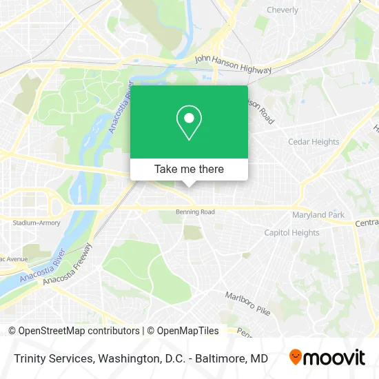
See Trinity Services, Washington, on the map
Public Transit to Trinity Services in Washington
Wondering how to get to Trinity Services in Washington? Moovit helps you find the best way to get to Trinity Services with step-by-step directions from the nearest public transit station.
Moovit provides free maps and live directions to help you navigate through your city. View schedules, routes, timetables, and find out how long does it take to get to Trinity Services in real time.
Looking for the nearest stop or station to Trinity Services? Check out this list of stops closest to your destination: Benning Rd Ne+44 St NE; Benning Rd Metro Station; E Capitol St Ne+Benning Rd NE; E Capitol St Se+46 St SE; Minnesota Ave.
Bus: C21, D20, D24, D2X, C57, C23, C37.Metro: BLUE, SILVER, ORANGE.
Want to see if there’s another route that gets you there at an earlier time? Moovit helps you find alternative routes or times. Get directions from and directions to Trinity Services easily from the Moovit App or Website.
We make riding to Trinity Services easy, which is why over 1.7 million users, including users in Washington, trust Moovit as the best app for public transit. You don’t need to download an individual bus app or train app, Moovit is your all-in-one transit app that helps you find the best bus time or train time available.
For information on prices of bus and metro, costs and ride fares to Trinity Services, please check the Moovit app.
Use the app to navigate to popular places including to the airport, hospital, stadium, grocery store, mall, coffee shop, school, college, and university.
Trinity Services Address: 4401 Brooks St NE street in Washington
- Winners Chapel International, Washington Dc,
- Braids, Beads, & Things,
- Apex Assisted Living,
- Getcoins Bitcoin Atm,
- Some Inc,
- Glory Swags Wear & Clothing,
- Western Union,
- Washington Recovery Center,
- Amazon Locker - Carnation,
- Winters Wonderland Early Childcare,
- Rooted-N-Nature Body Products,
- Fort Chaplin Park Apartments,
- Denny's,
- Banda Burrito,
- Denny's Restaurant,
- Benning Mart,
- Shrimpboat Plaza,
- Benning Road Northeast & East Capitol Street Northeast,
- Shrimp Boat,
- Boys And Girls Club Of Greater Washington
Places Near Trinity Services (Washington)
- National Museum of African American History and Culture, Washington,
- Warner Theatre, Washington,
- Georgetown, Washington,
- Washington DC VA Medical Center, Washington,
- M&T Bank Stadium, Baltimore,
- Rock Creek Tennis Center, Washington,
- Pennsylvania Ave NW (3rd st and pennsylvania), Washington,
- National Zoo, Washington,
- Marriott Marquis Washington, DC, Washington,
- Museum Of The Bible, Washington,
- Sibley Memorial Hospital, Washington,
- Basilica of the National Shrine, Washington,
- National Theatre, Washington,
- Amazon Hq2, Arlington County,
- Westfield Montgomery Mall, Montgomery County,
- PG Mall, Prince George's County,
- Washington National Cathedral, Washington,
- Camden Yards, Baltimore,
- The Anthem, Washington,
- Capital One Arena, Washington
How to get to popular places in Washington, D.C. - Baltimore, MD with public transit
Get around Washington by public transit!
Traveling around Washington has never been so easy. See step by step directions as you travel to any attraction, street or major public transit station. View bus and train schedules, arrival times, service alerts and detailed routes on a map, so you know exactly how to get to anywhere in Washington.
When traveling to any destination around Washington use Moovit's Live Directions with Get Off Notifications to know exactly where and how far to walk, how long to wait for your line, and how many stops are left. Moovit will alert you when it's time to get off — no need to constantly re-check whether yours is the next stop.
Wondering how to use public transit in Washington or how to pay for public transit in Washington? Moovit public transit app can help you navigate your way with public transit easily, and at minimum cost. It includes public transit fees, ticket prices, and costs. Looking for a map of Washington public transit lines? Moovit public transit app shows all public transit maps in Washington with all Bus, Train, Metro, Light Rail and Ferry routes and stops on an interactive map.
Washington, D.C. - Baltimore, MD has 5 transit type(s), including: Bus, Train, Metro, Light Rail and Ferry, operated by several transit agencies, including WMATA, Montgomery County Ride On, Fairfax Connector, TheBus, PRTC, DASH - Alexandria, Arlington Transit (ART), RTA of Central Maryland, MDOT MTA, MDOT MTA Light RailLink, MDOT MTA Commuter Bus, MDOT MTA Local Bus, FXBGO!, Virginia Railway Express (VRE) and MARC