Truman / Maclay stop - Thursday schedule
| Line | Direction | Time |
|---|---|---|
| 234 | LA Mission College | 4:39 AM |
| 224 | Sylmar Metrolink Station | 4:43 AM |
| 234 | LA Mission College | 5:01 AM |
| 234 | Sylmar Metrolink Station | 5:23 AM |
| 294 | Sylmar Metrolink Station | 5:28 AM |
| 234 | Sylmar Metrolink Station | 5:45 AM |
| 224 | Olive View Medical Center | 5:47 AM |
| 294 | Sylmar Metrolink Station | 6:01 AM |
| 234 | LA Mission College | 6:06 AM |
| 224 | Olive View Medical Center | 6:09 AM |
| 234 | LA Mission College | 6:21 AM |
| 224 | Sylmar Metrolink Station | 6:29 AM |
| 294 | Sylmar Metrolink Station | 6:31 AM |
| 234 | Sylmar Metrolink Station | 6:35 AM |
| 224 | Olive View Medical Center | 6:45 AM |
| 234 | LA Mission College | 6:47 AM |
| 234 | Sylmar Metrolink Station | 6:59 AM |
| 224 | Sylmar Metrolink Station | 7:00 AM |
| 294 | Sylmar Metrolink Station | 7:02 AM |
| 761 | Sylmar Metrolink Station | 7:04 AM |
| 234 | LA Mission College | 7:10 AM |
| 224 | Olive View Medical Center | 7:17 AM |
| 234 | Sylmar Metrolink Station | 7:22 AM |
| 761 | Sylmar Metrolink Station | 7:28 AM |
| 224 | Sylmar Metrolink Station | 7:32 AM |
Directions to Truman / Maclay stop (San Fernando) with public transit
The following transit lines have routes that pass near Truman / Maclay
 Bus: 224, 234, 761, 294, 230.
- Train: AV LINE.
How to get to Truman / Maclay stop by bus?
Click on the bus route to see step by step directions with maps, line arrival times and updated time schedules.
How to get to Truman / Maclay stop by train?
Click on the train route to see step by step directions with maps, line arrival times and updated time schedules.
Bus stops near Truman / Maclay stop in San Fernando
- Truman / Maclay, 1 min walk,
- Truman / San Fernando Mission, 4 min walk,
Train stations near Truman / Maclay station in San Fernando
- Sylmar/San Fernando Metrolink, 44 min walk,
Bus lines to Truman / Maclay stop in San Fernando
- 224, Olive View Medical Center,
- 234, Sherman Oaks Galleria,
- 294, Burbank Station,
- 761, Expo / Sepulveda Station,
- 230, Sylmar Metrolink Station,
- 235/236, Sylmar Station,
What are the closest stations to Truman / Maclay?
The closest stations to Truman / Maclay are:
- Truman / Maclay is 55 yards away, 1 min walk.
- Truman / San Fernando Mission is 268 yards away, 4 min walk.
- Sylmar/San Fernando Metrolink is 3755 yards away, 44 min walk.
Which bus lines stop near Truman / Maclay?
These bus lines stop near Truman / Maclay: 224, 234, 761.
Which train line stops near Truman / Maclay?
AV LINE (Outbound to Lancaster)
What’s the nearest bus station to Truman / Maclay in San Fernando?
The nearest bus station to Truman / Maclay in San Fernando is Truman / Maclay. It’s a 1 min walk away.
What time is the first train to Truman / Maclay in San Fernando?
The AV LINE is the first train that goes to Truman / Maclay in San Fernando. It stops nearby at 5:43 AM.
What time is the last train to Truman / Maclay in San Fernando?
The AV LINE is the last train that goes to Truman / Maclay in San Fernando. It stops nearby at 9:43 PM.
What time is the first bus to Truman / Maclay in San Fernando?
The 234 is the first bus that goes to Truman / Maclay in San Fernando. It stops nearby at 3:26 AM.
What time is the last bus to Truman / Maclay in San Fernando?
The 224 is the last bus that goes to Truman / Maclay in San Fernando. It stops nearby at 3:44 AM.
Truman / Maclay station
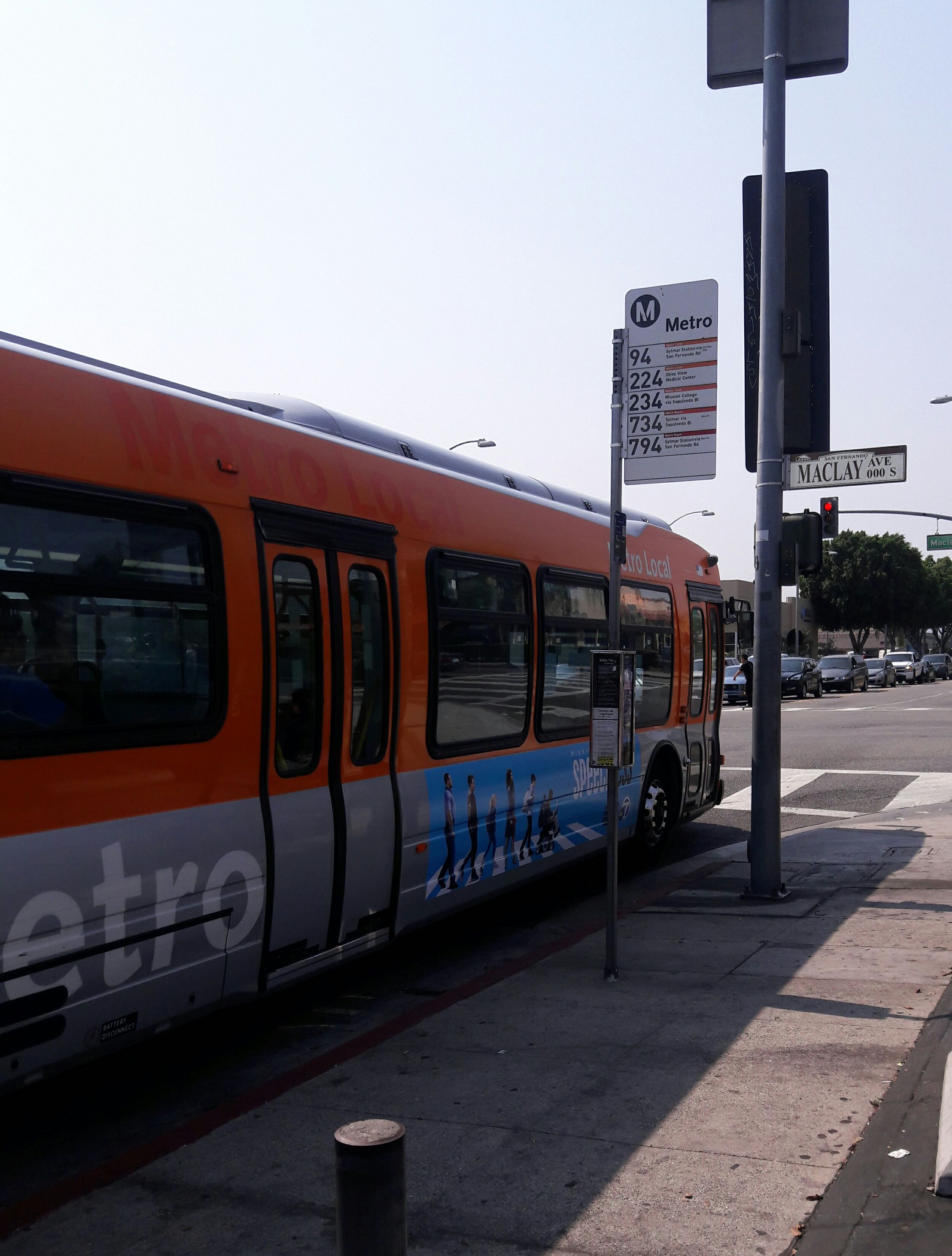 Taken by JONATHAN C
See Truman / Maclay stop, San Fernando, on the map
Public transit to Truman / Maclay stop (ID: 6617) in San Fernando
Looking for directions to Truman / Maclay in San Fernando, United States?
Download the Moovit App to find the current schedule and step-by-step directions for Bus or Train routes that pass through Truman / Maclay.
Looking for the nearest stops closest to Truman / Maclay ? Check out this list of closest stops to your destination: Truman / Maclay; Truman / San Fernando Mission; Sylmar/San Fernando Metrolink.
Bus: 224, 234, 761, 294, 230, 235/236.Train: AV LINE.
We make riding on public transit to Truman / Maclay easy, which is why over 1.5 million users, including users in San Fernando trust Moovit as the best app for public transit.
Use the app to navigate to popular places including to the airport, hospital, stadium, grocery store, mall, coffee shop, school, college, and university.
Truman / Maclay stop’s code is 6617
The first line to this stop is 234, at 4:39 AM, and the last line is 234 at 3:56 AM.
104 S Maclay Ave, San Fernando, CA, USA
This stop serves Metro’s lines
Popular routes from Truman / Maclay stop, San Fernando
- Truman / Maclay,
- Truman / San Fernando Mission
Bus stops near Truman / Maclay stop
- Sylmar/San Fernando Metrolink
Train station near Truman / Maclay station
- Gage Ave & Compton Ave,
- Garvey Ave. and Peck Rd.,
- Olympic / Burlington,
- Olympic / Downey,
- Melrose / Vine,
- Western / 39th,
- Sunset / Bellagio,
- Garden Grove-The City,
- Soledad Canyon Rd & Canyon Country Prk,
- Devonshire & Balboa,
- Bellflower & Atherton SW,
- York / Avenue 57,
- El Segundo Station,
- Santa Monica / Beverly,
- Ventura Rd & 5th,
- Santa Monica / Westwood,
- Washington/Passons,
- Santa Monica/San Vicente,
- Universal / Studio City Station,
- Fontana Metrolink
Popular public transit stations in San Fernando
Get around San Fernando by public transit!
Traveling around San Fernando has never been so easy. See step by step directions as you travel to any attraction, street or major public transit station. View bus and train schedules, arrival times, service alerts and detailed routes on a map, so you know exactly how to get to anywhere in San Fernando.
When traveling to any destination around San Fernando use Moovit's Live Directions with Get Off Notifications to know exactly where and how far to walk, how long to wait for your line, and how many stops are left. Moovit will alert you when it's time to get off — no need to constantly re-check whether yours is the next stop.
Wondering how to use public transit in San Fernando or how to pay for public transit in San Fernando? Moovit public transit app can help you navigate your way with public transit easily, and at minimum cost. It includes public transit fees, ticket prices, and costs. Looking for a map of San Fernando public transit lines? Moovit public transit app shows all public transit maps in San Fernando with all Bus, Train, Subway, Ferry and Funicular routes and stops on an interactive map.
Los Angeles has 5 transit type(s), including: Bus, Train, Subway, Ferry and Funicular, operated by several transit agencies, including Metro, Alhambra Community Transit, Arcadia Transit, Artesia Transit, AVTA, Baldwin Park Transit, Beach Cities Transit, Beaumont Transit, Bell Gardens Town Trolley, Bellflower Bus, Big Blue Bus, Burbank Bus, Calabasas Trolley, Camarillo Area Transit and Carson Circuit