Van Buren St & 111th Av stop - Thursday schedule
| Line | Direction | Time |
|---|---|---|
| 106 | Westbound | 5:38 AM |
| 106 | Westbound | 6:42 AM |
| 106 | Westbound | 7:16 AM |
| 106 | Westbound | 7:46 AM |
| 106 | Westbound | 8:16 AM |
| 106 | Westbound | 8:46 AM |
| 106 | Westbound | 9:16 AM |
| 106 | Westbound | 9:46 AM |
| 106 | Westbound | 10:16 AM |
| 106 | Westbound | 10:46 AM |
| 106 | Westbound | 11:16 AM |
| 106 | Westbound | 11:46 AM |
| 106 | Westbound | 12:16 PM |
| 106 | Westbound | 12:46 PM |
| 106 | Westbound | 1:16 PM |
| 106 | Westbound | 1:46 PM |
| 106 | Westbound | 2:16 PM |
| 106 | Westbound | 2:46 PM |
| 106 | Westbound | 3:16 PM |
| 106 | Westbound | 3:46 PM |
| 106 | Westbound | 4:16 PM |
| 106 | Westbound | 4:46 PM |
| 106 | Westbound | 5:16 PM |
| 106 | Westbound | 5:46 PM |
| 106 | Westbound | 6:16 PM |
Directions to Van Buren St & 111th Av stop (Avondale) with public transit
The following transit lines have routes that pass near Van Buren St & 111th Av
 Bus: 3, 563.
How to get to Van Buren St & 111th Av stop by bus?
Click on the bus route to see step by step directions with maps, line arrival times and updated time schedules.
Bus stops near Van Buren St & 111th Av stop in Avondale
- Avondale Bl & Van Buren St, 10 min walk,
- Avondale Tc, 15 min walk,
Bus lines to Van Buren St & 111th Av stop in Avondale
- 3, Galvin Pkwy+Van Buren,
- 563, Buckeye Pnr,
What are the closest stations to Van Buren St & 111th Av?
The closest stations to Van Buren St & 111th Av are:
- Avondale Bl & Van Buren St is 779 yards away, 10 min walk.
- Avondale Tc is 1206 yards away, 15 min walk.
Which bus line stops near Van Buren St & 111th Av?
3 (Westbound)
What’s the nearest bus station to Van Buren St & 111th Av in Avondale?
The nearest bus station to Van Buren St & 111th Av in Avondale is Avondale Bl & Van Buren St. It’s a 10 min walk away.
What time is the first bus to Van Buren St & 111th Av in Avondale?
The 3 is the first bus that goes to Van Buren St & 111th Av in Avondale. It stops nearby at 5:12 AM.
What time is the last bus to Van Buren St & 111th Av in Avondale?
The 3 is the last bus that goes to Van Buren St & 111th Av in Avondale. It stops nearby at 9:53 PM.
Van Buren St & 111th Av station
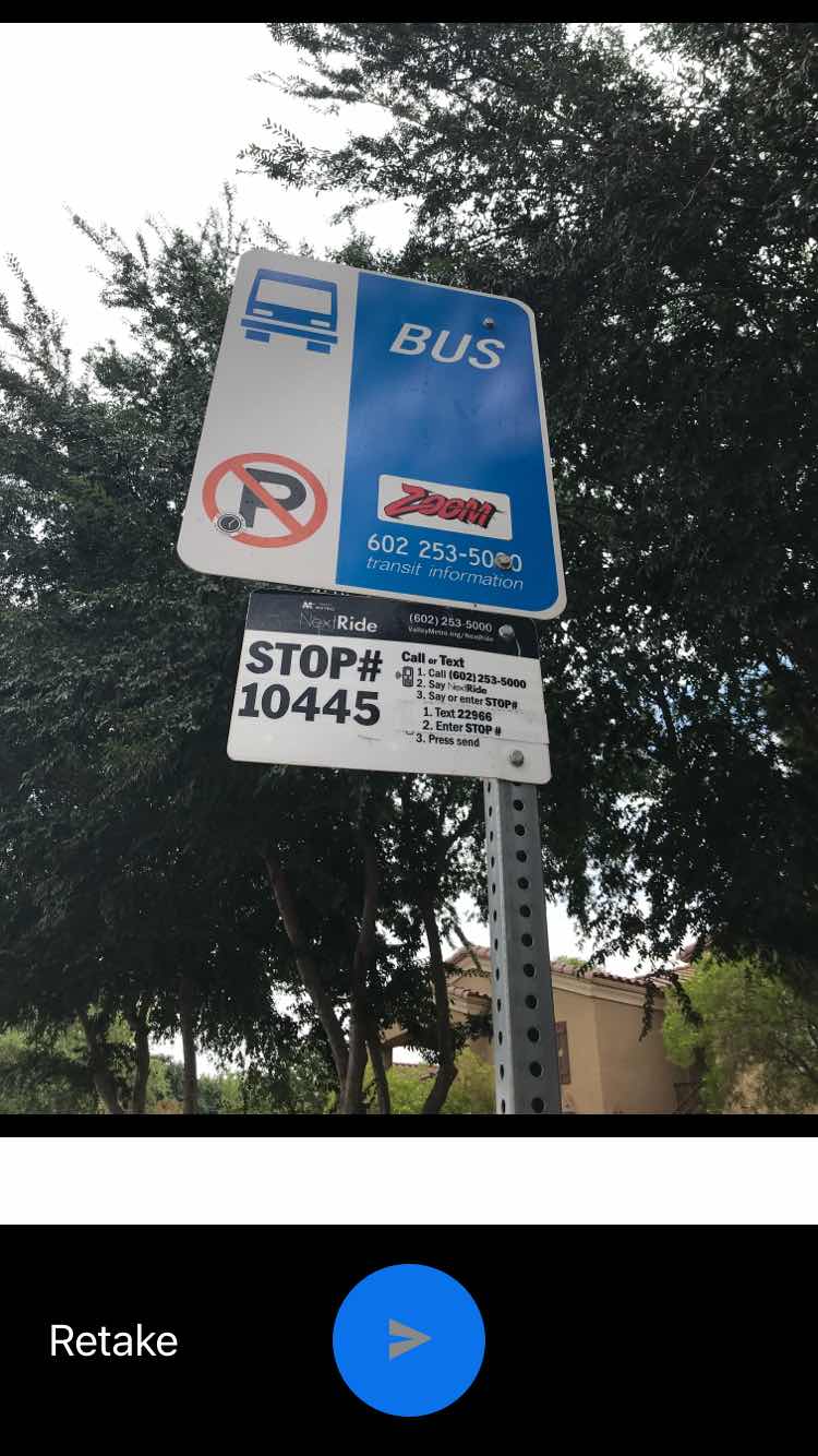 Taken by Anonymous
See Van Buren St & 111th Av stop, Avondale, on the map
Public transit to Van Buren St & 111th Av stop (ID: 10445) in Avondale
Looking for directions to Van Buren St & 111th Av in Avondale, United States?
Download the Moovit App to find the current schedule and step-by-step directions for Bus routes that pass through Van Buren St & 111th Av.
Looking for the nearest stops closest to Van Buren St & 111th Av ? Check out this list of closest stops to your destination: Avondale Bl & Van Buren St; Avondale Tc.
Bus: 3, 563.
We make riding on public transit to Van Buren St & 111th Av easy, which is why over 1.5 million users, including users in Avondale trust Moovit as the best app for public transit.
Use the app to navigate to popular places including to the airport, hospital, stadium, grocery store, mall, coffee shop, school, college, and university.
Van Buren St & 111th Av stop’s code is 10445
The first line to this stop is 106, at 5:38 AM, and the last line is 106 at 9:05 PM.
This stop serves Valley Metro-Bus’s lines
- Avondale Bl & Van Buren St,
- Avondale Tc
Bus stops near Van Buren St & 111th Av stop
- Priest Dr & Warner Rd,
- Camelback Rd & 40th Av,
- 43rd Av & Van Buren St,
- Van Buren St & Dysart Rd,
- Roosevelt St & 18th St,
- 16th St & Thomas Rd,
- Bethany Home Rd & Central Av,
- 7th St & Roma Av,
- Arrowhead Mall South,
- Thomas Rd & 75th Av,
- Bell Rd & 31st Av,
- University Dr & Alma School Rd,
- Adams St & 18th Av,
- Priest Dr & Center Pkwy,
- 7th Av & Roosevelt St,
- Kyrene Rd & Guadalupe Rd,
- 7th St & Virginia Av,
- 111th Av & Thunderbird Bl,
- Alma School Rd & Guadalupe Rd,
- Priest Dr & Baseline Rd
Popular public transit stations in Avondale
Get around Avondale by public transit!
Traveling around Avondale has never been so easy. See step by step directions as you travel to any attraction, street or major public transit station. View bus and train schedules, arrival times, service alerts and detailed routes on a map, so you know exactly how to get to anywhere in Avondale.
When traveling to any destination around Avondale use Moovit's Live Directions with Get Off Notifications to know exactly where and how far to walk, how long to wait for your line, and how many stops are left. Moovit will alert you when it's time to get off — no need to constantly re-check whether yours is the next stop.
Wondering how to use public transit in Avondale or how to pay for public transit in Avondale? Moovit public transit app can help you navigate your way with public transit easily, and at minimum cost. It includes public transit fees, ticket prices, and costs. Looking for a map of Avondale public transit lines? Moovit public transit app shows all public transit maps in Avondale with all Bus and Light Rail routes and stops on an interactive map.
Phoenix has 2 transit type(s), including: Bus and Light Rail, operated by several transit agencies, including Valley Metro-Tram, Valley Metro-Bus, Phoenix Sky Harbor International Airport, Greyhound-us and FlixBus-us