How to get to Francesco De Sanctis Street by bus?
Click on the bus route to see step by step directions with maps, line arrival times and updated time schedules.
From Mario Bellucci Square, Vetralla
401 minFrom Bambino Gesù Hospital - Palidoro, Fiumicino
131 minFrom Santa Marinella Beach, Santa Marinella
42 minFrom Enrico Bassano Street 10, Rome
206 minFrom Marina of San Nicola, Ladispoli
119 minFrom Belcolle Hospital, Viterbo
336 minFrom La Storta, Rome
206 minFrom Passoscuro, Fiumicino
138 min
How to get to Francesco De Sanctis Street by train?
Click on the train route to see step by step directions with maps, line arrival times and updated time schedules.
Bus stops near Francesco De Sanctis Street in Civitavecchia
Train station near Francesco De Sanctis Street in Civitavecchia
- Civitavecchia, 16 min walk,VIEW
Bus lines to Francesco De Sanctis Street in Civitavecchia
- 2, City Center - San Liborio District,VIEW
- COTRAL, Blera - Civitavecchia,VIEW
- COTRAL, Montevirginio - Civitavecchia,VIEW
- 1C, City Center,VIEW
- G1, Scolastica | Bus Depot - Via dell'Immacolata,VIEW
- G2, School Route | Railway Station - Via dell'Immacolata,VIEW
- G3, School Line | Garibaldi Street - Polveriera Street,VIEW
- 4, New Cemetery - Borgata Aurelia - La Scaglia,VIEW
- COTRAL, Santa Severa - Civitavecchia,VIEW
- COTRAL, Roma Cornelia - Tolfa,VIEW
- COTRAL, Civitavecchia - La Bianca,VIEW
- COTRAL, Civitavecchia - Tolfa,VIEW
- COTRAL, Roma Cornelia - Civitavecchia,VIEW
- COTRAL, Civitavecchia - Roma Saxa Rubra,VIEW
- 1, City Center - Campo dell'Oro,VIEW
- COTRAL, Allumiere - Civitavecchia,VIEW
- COTRAL, Canino - Civitavecchia,VIEW
- COTRAL, La Bianca - Civitavecchia,VIEW
- COTRAL, Civitavecchia - Civitavecchia,VIEW
- COTRAL, Civitavecchia - Oriolo Romano,VIEW
What are the closest stations to Francesco De Sanctis Street?
The closest stations to Francesco De Sanctis Street are:
- Civitavecchia | Frati Cappuccini Square is 176 meters away, 3 min walk.
- Civitavecchia | Via Terme Traiano Via De Sanctis is 213 meters away, 4 min walk.
- Civitavecchia is 1195 meters away, 16 min walk.
Which bus lines stop near Francesco De Sanctis Street?
These bus lines stop near Francesco De Sanctis Street: 2, COTRAL.
Which train lines stop near Francesco De Sanctis Street?
These train lines stop near Francesco De Sanctis Street: FL5, RV.
What’s the nearest train station to Francesco De Sanctis Street in Civitavecchia?
The nearest train station to Francesco De Sanctis Street in Civitavecchia is Civitavecchia. It’s a 16 min walk away.
What’s the nearest bus station to Francesco De Sanctis Street in Civitavecchia?
The nearest bus station to Francesco De Sanctis Street in Civitavecchia is Civitavecchia | Frati Cappuccini Square. It’s a 3 min walk away.
What time is the first train to Francesco De Sanctis Street in Civitavecchia?
The FL5 is the first train that goes to Francesco De Sanctis Street in Civitavecchia. It stops nearby at 5:58 AM.
What time is the last train to Francesco De Sanctis Street in Civitavecchia?
The FL5 is the last train that goes to Francesco De Sanctis Street in Civitavecchia. It stops nearby at 12:47 AM.
What time is the first bus to Francesco De Sanctis Street in Civitavecchia?
The COTRAL is the first bus that goes to Francesco De Sanctis Street in Civitavecchia. It stops nearby at 5:36 AM.
What time is the last bus to Francesco De Sanctis Street in Civitavecchia?
The 1 is the last bus that goes to Francesco De Sanctis Street in Civitavecchia. It stops nearby at 8:18 PM.
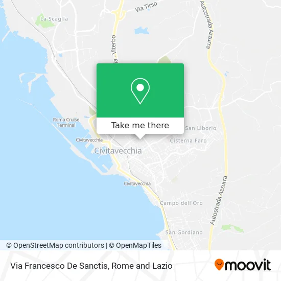
See Francesco De Sanctis Street, Civitavecchia, on the map
Public Transit to Francesco De Sanctis Street in Civitavecchia
Wondering how to get to Francesco De Sanctis Street in Civitavecchia? Moovit helps you find the best way to get to Francesco De Sanctis Street with step-by-step directions from the nearest public transit station.
Moovit provides free maps and live directions to help you navigate through your city. View schedules, routes, timetables, and find out how long does it take to get to Francesco De Sanctis Street in real time.
Looking for the nearest stop or station to Francesco De Sanctis Street? Check out this list of stops closest to your destination: Civitavecchia | Frati Cappuccini Square; Civitavecchia | Via Terme Traiano Via De Sanctis; Civitavecchia.
Bus: 2, COTRAL, 1C, G1, G2, G3, 4, 1, 3.Train: FL5, RV, R, R, R.
Want to see if there’s another route that gets you there at an earlier time? Moovit helps you find alternative routes or times. Get directions from and directions to Francesco De Sanctis Street easily from the Moovit App or Website.
We make riding to Francesco De Sanctis Street easy, which is why over 1.5 million users, including users in Civitavecchia, trust Moovit as the best app for public transit. You don’t need to download an individual bus app or train app, Moovit is your all-in-one transit app that helps you find the best bus time or train time available.
For information on prices of bus, train and metro, costs and ride fares to Francesco De Sanctis Street, please check the Moovit app.
Use the app to navigate to popular places including to the airport, hospital, stadium, grocery store, mall, coffee shop, school, college, and university.
Francesco De Sanctis Street Address: 00053 Civitavecchia street in Civitavecchia
- Le Stelle Tobacco Shop by d'Avino Maria Cristina,
- Amazon Counter-Tobacco Shop Le Stelle,
- INPS - National Institute for Social Security,
- Antonio Canova Street, 2,
- Blue Pastry Shop,
- INPS,
- Giovanna Perna,
- Falcone Alessandro Angelo,
- Paben Import,
- Dermatology and Venereal Diseases Studio,
- Dr. D'Angelo Office,
- Don Annideo Pandolfi Street,
- Crai Supermarkets Large Stores Commercial Centers,
- Dodo S.,
- Di. Ro.,
- Revenue Agency,
- Gianni Rodari Elementary School,
- Civitavecchia Municipality,
- Csp,
- Trajan Thermal Baths Street 39 / A
Places Near Francesco De Sanctis Street (Civitavecchia)
- Tiber Island, Rome,
- Gravity, Rome,
- Paths, Rome,
- The Wow Side, Fiumicino,
- Casilino Polyclinic, Rome,
- Auditorium Music Park, Rome,
- IDI (Dermopatico Dell'Immacolata Institute), Rome,
- Cristo Re Hospital, Rome,
- Scuderie Del Quirinale, Rome,
- Termini Station, Rome,
- Santa Maria Maggiore, Rome,
- Roma Est Shopping Center, Rome,
- Coppedè Quarter, Rome,
- Olympic Stadium, Rome, Rome,
- The Sail, Rome,
- Tor Vergata, Rome,
- Villa Borghese, Rome,
- Trastevere Quarter, Rome,
- Gemelli Polyclinic, Rome,
- Sandro Pertini Hospital, Rome
How to get to popular places in Rome and Lazio with public transit
Get around Civitavecchia by public transit!
Traveling around Civitavecchia has never been so easy. See step by step directions as you travel to any attraction, street or major public transit station. View bus and train schedules, arrival times, service alerts and detailed routes on a map, so you know exactly how to get to anywhere in Civitavecchia.
When traveling to any destination around Civitavecchia use Moovit's Live Directions with Get Off Notifications to know exactly where and how far to walk, how long to wait for your line, and how many stops are left. Moovit will alert you when it's time to get off — no need to constantly re-check whether yours is the next stop.
Wondering how to use public transit in Civitavecchia or how to pay for public transit in Civitavecchia? Moovit public transit app can help you navigate your way with public transit easily, and at minimum cost. It includes public transit fees, ticket prices, and costs. Looking for a map of Civitavecchia public transit lines? Moovit public transit app shows all public transit maps in Civitavecchia with all Bus, Train, Metro, Light Rail, Ferry, Funicular and Gondola routes and stops on an interactive map.
Rome and Lazio has 7 transit type(s), including: Bus, Train, Metro, Light Rail, Ferry, Funicular and Gondola, operated by several transit agencies, including ATAC, Cotral, Trenitalia, Troiani Transportation Services, BIS, ATR Mobility, Tuscia, Shuttle, Seatour, Troiani Bus Lines, CSC Mobility, Terravision, ATRAL, Tambus and Sitbus