Victory Bl/Cebra Av stop - Friday schedule
| Line | Direction | Time |
|---|---|---|
| S61 | Staten Island Mall Yukon Av | 6:05 AM |
| S48 | Arlington Holland Av Via Forest | 6:06 AM |
| S62 | Travis Via Victory | 6:06 AM |
| S66 | Port Richmond Via Grymes Hill | 6:06 AM |
| S62 | Travis Via Victory | 6:36 AM |
| S66 | Port Richmond Via Grymes Hill | 6:36 AM |
| S61 | Staten Island Mall Yukon Av | 6:37 AM |
| S48 | Arlington Holland Av Via Forest | 6:38 AM |
| S48 | Arlington Holland Av Via Forest | 6:53 AM |
| S62 | Travis Via Victory | 7:06 AM |
| S61 | Staten Island Mall Yukon Av | 7:07 AM |
| S66 | Port Richmond Via Grymes Hill | 7:07 AM |
| S48 | Arlington Holland Av Via Forest | 7:08 AM |
| S62 | Si College Via Victory | 7:21 AM |
| S61 | Staten Island Mall Yukon Av | 7:22 AM |
| S48 | Arlington Holland Av Via Forest | 7:23 AM |
| S62 | Travis Via Victory | 7:37 AM |
| S61 | Staten Island Mall Yukon Av | 7:37 AM |
| S66 | Port Richmond Via Grymes Hill | 7:37 AM |
| S48 | Arlington Holland Av Via Forest | 7:37 AM |
| S62 | Travis Via Victory | 7:52 AM |
| S61 | Staten Island Mall Yukon Av | 7:52 AM |
| S48 | Arlington Holland Av Via Forest | 7:54 AM |
| S61 | Staten Island Mall Yukon Av | 8:06 AM |
| S66 | Port Richmond Via Grymes Hill | 8:06 AM |
Directions to Victory Bl/Cebra Av stop (Staten Island) with public transit
The following transit lines have routes that pass near Victory Bl/Cebra Av
 Bus: S46, S48, S52, S61, S62.
- Subway: SIR.
- Ferry: STATEN ISLAND FERRY, SG.
How to get to Victory Bl/Cebra Av stop by bus?
Click on the bus route to see step by step directions with maps, line arrival times and updated time schedules.
Bus stops near Victory Bl/Cebra Av stop in Staten Island
- Cebra Av/Victory Blvd, 1 min walk,
- Victory Blvd/Cebra Av, 2 min walk,
Subway stations near Victory Bl/Cebra Av station in Staten Island
- Tompkinsville, 15 min walk,
Ferry stations near Victory Bl/Cebra Av station in Staten Island
- St. George Ferry Terminal, 25 min walk,
- St. George, 26 min walk,
Bus lines to Victory Bl/Cebra Av stop in Staten Island
- S52, Staten Island Hospital Seaview Av,
- S46, West Shore Plz Via Castleton,
- S48, St George Ferry Via Forest,
- S61, Staten Island Mall Yukon Av,
- S62, Travis Via Victory,
- S66, St George Ferry Via Grymes Hill,
What are the closest stations to Victory Bl/Cebra Av?
The closest stations to Victory Bl/Cebra Av are:
- Cebra Av/Victory Blvd stop is 25 yards away, 1 min walk.
- Victory Blvd/Cebra Av stop is 84 yards away, 2 min walk.
- Tompkinsville station is 1246 yards away, 15 min walk.
- St. George Ferry Terminal is 2116 yards away, 25 min walk.
- St. George station is 2219 yards away, 26 min walk.
Which bus lines stop near Victory Bl/Cebra Av?
These bus lines stop near Victory Bl/Cebra Av: S46, S48, S52, S61, S62.
What’s the nearest subway station to Victory Bl/Cebra Av in Staten Island?
The nearest subway station to Victory Bl/Cebra Av in Staten Island is Tompkinsville. It’s a 15 min walk away.
What’s the nearest bus station to Victory Bl/Cebra Av in Staten Island?
The nearest bus station to Victory Bl/Cebra Av in Staten Island is Cebra Av/Victory Blvd. It’s a 1 min walk away.
What’s the nearest ferry station to Victory Bl/Cebra Av in Staten Island?
The nearest ferry station to Victory Bl/Cebra Av in Staten Island is St. George Ferry Terminal. It’s a 25 min walk away.
What time is the first subway to Victory Bl/Cebra Av in Staten Island?
The SIR is the first subway that goes to Victory Bl/Cebra Av in Staten Island. It stops nearby at 3:06 AM.
What time is the last subway to Victory Bl/Cebra Av in Staten Island?
The SIR is the last subway that goes to Victory Bl/Cebra Av in Staten Island. It stops nearby at 3:13 AM.
What time is the first bus to Victory Bl/Cebra Av in Staten Island?
The S48 is the first bus that goes to Victory Bl/Cebra Av in Staten Island. It stops nearby at 3:03 AM.
What time is the last bus to Victory Bl/Cebra Av in Staten Island?
The S62 is the last bus that goes to Victory Bl/Cebra Av in Staten Island. It stops nearby at 3:13 AM.
What time is the first ferry to Victory Bl/Cebra Av in Staten Island?
The STATEN ISLAND FERRY is the first ferry that goes to Victory Bl/Cebra Av in Staten Island. It stops nearby at 3:00 AM.
What time is the last ferry to Victory Bl/Cebra Av in Staten Island?
The STATEN ISLAND FERRY is the last ferry that goes to Victory Bl/Cebra Av in Staten Island. It stops nearby at 2:55 AM.
Victory Bl/Cebra Av station
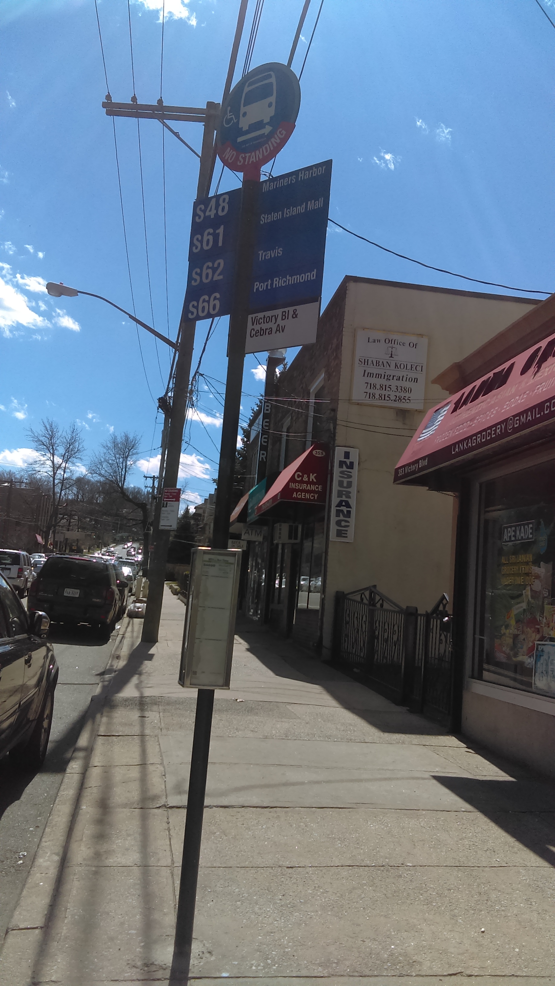 Taken by Morenita S.
See Victory Bl/Cebra Av stop, Staten Island, on the map
Public transit to Victory Bl/Cebra Av stop in Staten Island
Looking for directions to Victory Bl/Cebra Av in Staten Island, United States?
Download the Moovit App to find the current schedule and step-by-step directions for Bus or Ferry routes that pass through Victory Bl/Cebra Av.
Looking for the nearest stops closest to Victory Bl/Cebra Av ? Check out this list of closest stops to your destination: Cebra Av/Victory Blvd; Victory Blvd/Cebra Av; Tompkinsville; St. George Ferry Terminal; St. George.
Bus: S46, S48, S52, S61, S62, S66.Subway: SIR.Ferry: STATEN ISLAND FERRY, SG.
We make riding on public transit to Victory Bl/Cebra Av easy, which is why over 1.7 billion users, including users in Staten Island trust Moovit as the best app for public transit.
Use the app to navigate to popular places including to the airport, hospital, stadium, grocery store, mall, coffee shop, school, college, and university.
The first line to this stop is S61, at 6:05 AM, and the last line is S48 at 5:35 AM.
345 Victory Blvd, Staten Island, New York, NY, USA
This stop serves MTA Bus’s lines
- Cebra Av/Victory Blvd,
- Victory Blvd/Cebra Av
Bus stops near Victory Bl/Cebra Av stop
- Tompkinsville
Subway station near Victory Bl/Cebra Av station
- St. George Ferry Terminal,
- St. George
Ferry stations near Victory Bl/Cebra Av station
- 21 St-Queensbridge,
- Asbury Park,
- Rt 32 & Henry Dubois Dr,
- Main St @ Centre Ave,
- Oceanside,
- Port Washington,
- Millburn,
- Westfield,
- Hastings - On- Hudson,
- Borough Hall,
- City Hall,
- Valley Stream LIRR Sta.,
- Bernardsville,
- Kent Av/Williamsburg St East,
- Wassaic,
- East Tremont Av/Boston Rd,
- Coney Island-Stillwell Av,
- Jamaica Av/Francis Lewis Blvd,
- Annandale,
- Seaford
Popular public transit stations in Staten Island
Get around Staten Island by public transit!
Traveling around Staten Island has never been so easy. See step by step directions as you travel to any attraction, street or major public transit station. View bus and train schedules, arrival times, service alerts and detailed routes on a map, so you know exactly how to get to anywhere in Staten Island.
When traveling to any destination around Staten Island use Moovit's Live Directions with Get Off Notifications to know exactly where and how far to walk, how long to wait for your line, and how many stops are left. Moovit will alert you when it's time to get off — no need to constantly re-check whether yours is the next stop.
Wondering how to use public transit in Staten Island or how to pay for public transit in Staten Island? Moovit public transit app can help you navigate your way with public transit easily, and at minimum cost. It includes public transit fees, ticket prices, and costs. Looking for a map of Staten Island public transit lines? Moovit public transit app shows all public transit maps in Staten Island with all Bus, Train, Subway, Light Rail, Ferry and Cable Car routes and stops on an interactive map.
New York - New Jersey has 6 transit type(s), including: Bus, Train, Subway, Light Rail, Ferry and Cable Car, operated by several transit agencies, including MTA Subway, Metro-North Railroad, LIRR, PATH, MTA New York City Transit - Express routes, MTA Bus, NJ Transit, NYC Ferry, NICE bus, Bee-Line Bus, NJ Transit Rail, Norwalk Transit District, CTTransit - Waterbury-Meriden, Hartford Line and River Valley Transit