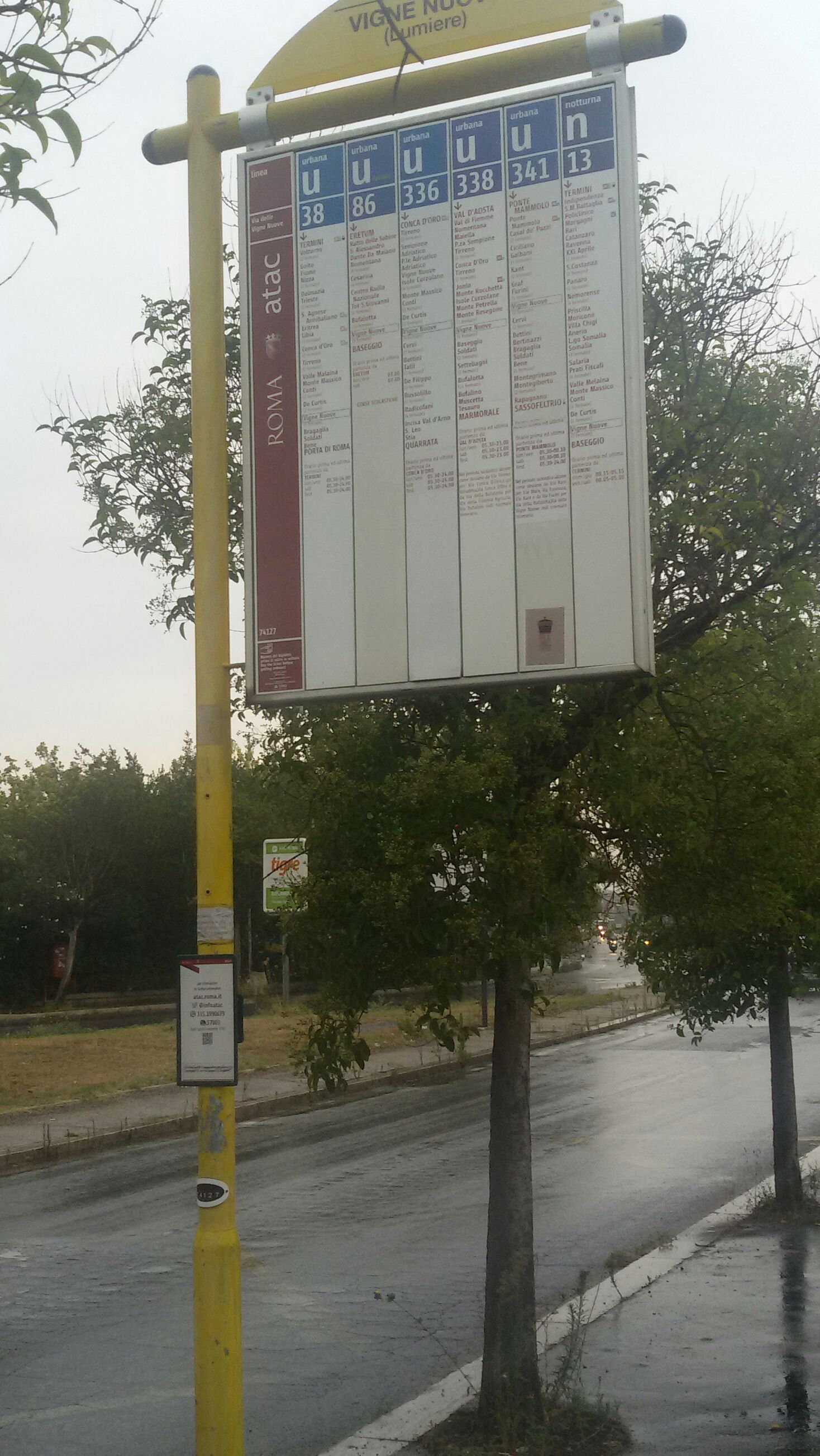
New Vines/Lumiere stop - Monday schedule
| Line | Direction | Time |
|---|---|---|
| 38 | Porta Di Roma | 4:58 AM |
| 341 | Sassofeltrio/Fidene Station (FL1) | 5:08 AM |
| 38 | Porta Di Roma | 5:18 AM |
| 341 | Sassofeltrio/Fidene Station (FL1) | 5:29 AM |
| 38 | Porta Di Roma | 5:33 AM |
| 338 | Marmorale | 5:43 AM |
| 336 | Quarrata | 5:47 AM |
| 38 | Porta Di Roma | 5:48 AM |
| 341 | Sassofeltrio/Fidene Station (FL1) | 5:50 AM |
| 338 | Marmorale | 6:02 AM |
| 38 | Porta Di Roma | 6:03 AM |
| 341 | Sassofeltrio/Fidene Station (FL1) | 6:07 AM |
| 336 | Quarrata | 6:08 AM |
| 341 | Sassofeltrio/Fidene Station (FL1) | 6:16 AM |
| 38 | Porta Di Roma | 6:18 AM |
| 341 | Sassofeltrio/Fidene Station (FL1) | 6:24 AM |
| 338 | Marmorale | 6:24 AM |
| 336 | Quarrata | 6:30 AM |
| 38 | Porta Di Roma | 6:33 AM |
| 341 | Sassofeltrio/Fidene Station (FL1) | 6:34 AM |
| 341 | Sassofeltrio/Fidene Station (FL1) | 6:40 AM |
| 338 | Marmorale | 6:43 AM |
| 38 | Porta Di Roma | 6:48 AM |
| 341 | Sassofeltrio/Fidene Station (FL1) | 6:49 AM |
| 336 | Quarrata | 6:56 AM |
Directions to New Vines/Lumiere stop (Rome) with public transit
The following transit lines have routes that pass near New Vines/Lumiere
 Bus: 338, 38, 336, 341, C5.
- Train: FL1, FL3, R.
- Metro: B.
How to get to New Vines/Lumiere stop by bus?
Click on the bus route to see step by step directions with maps, line arrival times and updated time schedules.
How to get to New Vines/Lumiere stop by train?
Click on the train route to see step by step directions with maps, line arrival times and updated time schedules.
How to get to New Vines/Lumiere stop by metro?
Click on the metro route to see step by step directions with maps, line arrival times and updated time schedules.
Bus stops near New Vines/Lumiere stop in Rome
- Cervi/Tofano, 2 min walk,
- Vigne Nuove/De Liguoro, 4 min walk,
- Vigne Nuove/Pasinetti, 4 min walk,
- De Curtis, 12 min walk,
Metro stations near New Vines/Lumiere station in Rome
- Jonio, 29 min walk,
Train stations near New Vines/Lumiere station in Rome
- Nuovo Salario, 38 min walk,
- Val D'Ala, 41 min walk,
Bus lines to New Vines/Lumiere stop in Rome
- 336, Val D'Ala Station (FS),
- 341, Sassofeltrio/Fidene Station (FL1),
- C5, Montebello Station (Regional Rail),
- 38, Porta Di Roma,
- 86, Eretum,
- 338, Val D'Aosta/Nomentana Station,
- 344, St. Giovanni In Argentella,
- 339, Circular Porro Lambertenghi - Nuovo Salario (FL1) - Jonio (MB) - Tufello - Vigne Nuove,
- 349, Circular Porro Lambertenghi - Jonio (MB) - Tufello - Vigne Nuove - Nuovo Salario (FL1),
What are the closest stations to New Vines/Lumiere?
The closest stations to New Vines/Lumiere are:
- Cervi/Tofano is 131 meters away, 2 min walk.
- Vigne Nuove/De Liguoro is 213 meters away, 4 min walk.
- Vigne Nuove/Pasinetti is 263 meters away, 4 min walk.
- De Curtis is 894 meters away, 12 min walk.
- Jonio is 2232 meters away, 29 min walk.
- Nuovo Salario is 2918 meters away, 38 min walk.
- Val D'Ala is 3148 meters away, 41 min walk.
Which bus lines stop near New Vines/Lumiere?
These bus lines stop near New Vines/Lumiere: 338, 38.
Which train line stops near New Vines/Lumiere?
FL1 (Fara S./Poggio M./Orte)
Which metro line stops near New Vines/Lumiere?
B (Rebibbia/Jonio)
What’s the nearest metro station to New Vines/Lumiere in Rome?
The nearest metro station to New Vines/Lumiere in Rome is Jonio. It’s a 29 min walk away.
What’s the nearest bus station to New Vines/Lumiere in Rome?
The nearest bus station to New Vines/Lumiere in Rome is Cervi/Tofano. It’s a 2 min walk away.
What time is the first metro to New Vines/Lumiere in Rome?
The B is the first metro that goes to New Vines/Lumiere in Rome. It stops nearby at 5:33 AM.
What time is the last metro to New Vines/Lumiere in Rome?
The B is the last metro that goes to New Vines/Lumiere in Rome. It stops nearby at 12:06 AM.
What time is the first train to New Vines/Lumiere in Rome?
The FL1 is the first train that goes to New Vines/Lumiere in Rome. It stops nearby at 5:45 AM.
What time is the last train to New Vines/Lumiere in Rome?
The FL1 is the last train that goes to New Vines/Lumiere in Rome. It stops nearby at 11:15 PM.
What time is the first bus to New Vines/Lumiere in Rome?
The 341 is the first bus that goes to New Vines/Lumiere in Rome. It stops nearby at 5:13 AM.
What time is the last bus to New Vines/Lumiere in Rome?
The 38 is the last bus that goes to New Vines/Lumiere in Rome. It stops nearby at 2:27 AM.
New Vines/Lumiere station
 Taken by Anonymous
See New Vines/Lumiere stop, Rome, on the map
Public transit to New Vines/Lumiere stop (ID: 74127) in Rome
Looking for directions to New Vines/Lumiere in Rome, Italy?
Download the Moovit App to find the current schedule and step-by-step directions for Bus, Metro or Train routes that pass through New Vines/Lumiere.
Looking for the nearest stops closest to New Vines/Lumiere ? Check out this list of closest stops to your destination: Cervi/Tofano; Vigne Nuove/De Liguoro; Vigne Nuove/Pasinetti; De Curtis; Jonio; Nuovo Salario; Val D'Ala.
Bus: 338, 38, 336, 341, C5, 86.Train: FL1, FL3, R.Metro: B.
We make riding on public transit to New Vines/Lumiere easy, which is why over 1.5 million users, including users in Rome trust Moovit as the best app for public transit.
Use the app to navigate to popular places including to the airport, hospital, stadium, grocery store, mall, coffee shop, school, college, and university.
New Vines/Lumiere stop’s code is 74127
The first line to this stop is 38, at 4:58 AM, and the last line is 38 at 2:25 AM.
Largo Fratelli Lumiere, Roma, Italy
This stop serves ATAC’s lines
Popular routes from New Vines/Lumiere stop, Rome
- Cervi/Tofano,
- Vigne Nuove/De Liguoro,
- Vigne Nuove/Pasinetti,
- De Curtis
Bus stops near New Vines/Lumiere stop
- Jonio
Metro station near New Vines/Lumiere station
- Nuovo Salario,
- Val D'Ala
Train stations near New Vines/Lumiere station
- 2 San Pietro Street,
- Rome Rebibbia (Metro B),
- Aurelia/Alibrandi,
- Poggio Moiano via Salaria Vecchia via Ulivi,
- Victor Emmanuel III Avenue,
- Acqua Acetosa Riverfront,
- National/Turin,
- Casilina/Torre Maura,
- Pozzo Del Principe Street, 63,
- Valmontone | Casilina Street (Km 44),
- Valle Aurelia (Metro),
- Ardea | Old Pontina Road Km 35.600,
- Circus Maximus (Metro),
- Bonelli Villa,
- Bravetta/Pisana,
- Policlinico Hospital,
- Stelvio,
- Numidio Quadrato (MA),
- Portuense/Imbrecciato,
- Ardea | Laurentina Street Pontina Vecchia Street
Popular public transit stations in Rome
Get around Rome by public transit!
Traveling around Rome has never been so easy. See step by step directions as you travel to any attraction, street or major public transit station. View bus and train schedules, arrival times, service alerts and detailed routes on a map, so you know exactly how to get to anywhere in Rome.
When traveling to any destination around Rome use Moovit's Live Directions with Get Off Notifications to know exactly where and how far to walk, how long to wait for your line, and how many stops are left. Moovit will alert you when it's time to get off — no need to constantly re-check whether yours is the next stop.
Wondering how to use public transit in Rome or how to pay for public transit in Rome? Moovit public transit app can help you navigate your way with public transit easily, and at minimum cost. It includes public transit fees, ticket prices, and costs. Looking for a map of Rome public transit lines? Moovit public transit app shows all public transit maps in Rome with all Bus, Train, Metro, Light Rail, Ferry, Funicular and Gondola routes and stops on an interactive map.
Rome and Lazio has 7 transit type(s), including: Bus, Train, Metro, Light Rail, Ferry, Funicular and Gondola, operated by several transit agencies, including ATAC, Cotral, Trenitalia, Troiani Transportation Services, BIS, ATR Mobility, Tuscia, Shuttle, Seatour, Troiani Bus Lines, CSC Mobility, Terravision, ATRAL, Tambus and Sitbus