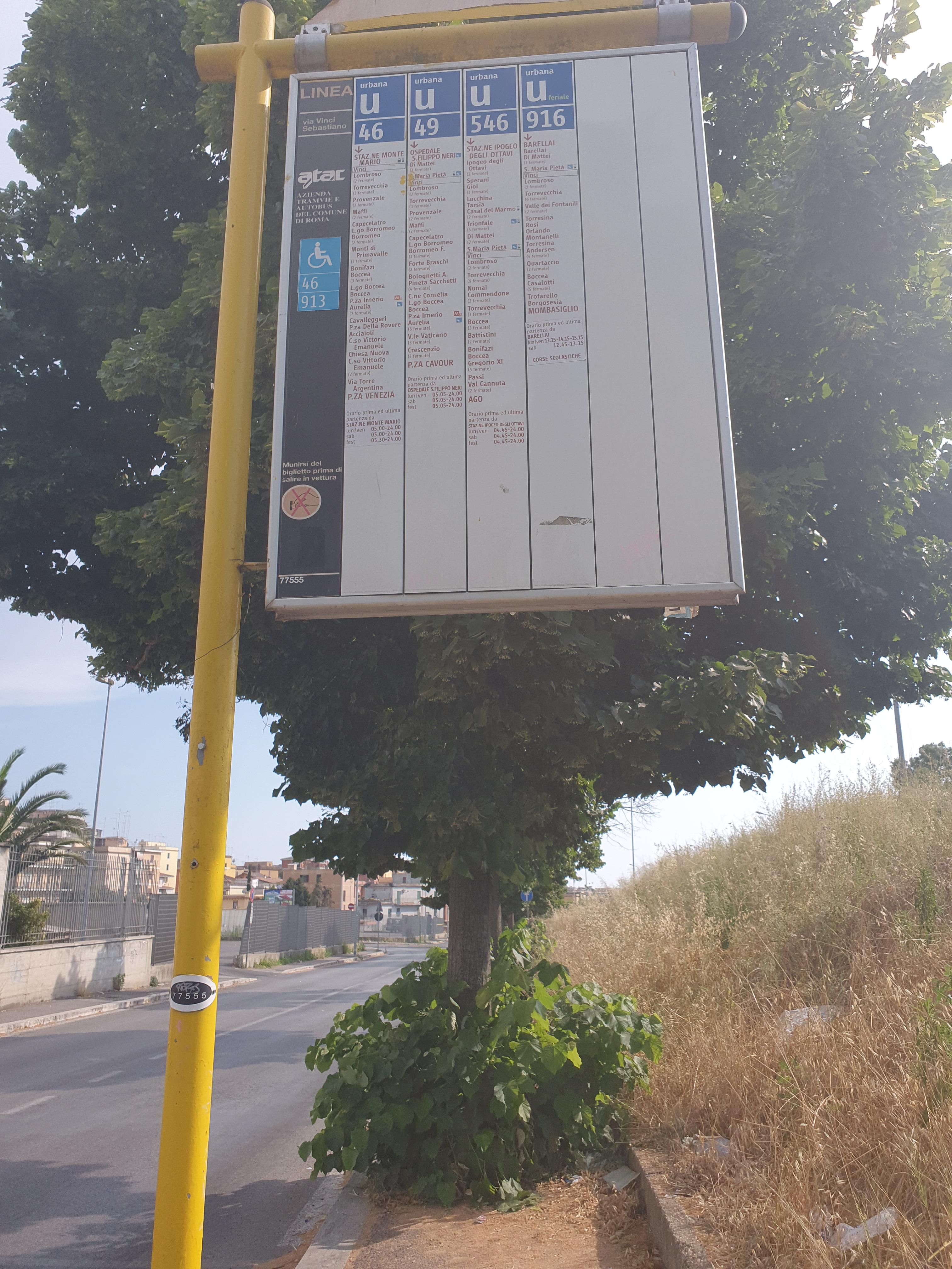
Vinci stop - Monday schedule
| Line | Direction | Time |
|---|---|---|
| 546 | Val Cannuta/Conforti | 4:58 AM |
| 46 | Piazza Venezia | 5:01 AM |
| 49 | Cavour Square | 5:08 AM |
| 46 | Piazza Venezia | 5:14 AM |
| 546 | Val Cannuta/Conforti | 5:20 AM |
| 49 | Cavour Square | 5:23 AM |
| 46 | Piazza Venezia | 5:27 AM |
| 49 | Cavour Square | 5:37 AM |
| 46 | Piazza Venezia | 5:40 AM |
| 546 | Val Cannuta/Conforti | 5:45 AM |
| 49 | Cavour Square | 5:51 AM |
| 46 | Piazza Venezia | 5:53 AM |
| 49 | Cavour Square | 6:06 AM |
| 46 | Piazza Venezia | 6:06 AM |
| 546 | Val Cannuta/Conforti | 6:07 AM |
| 46 | Piazza Venezia | 6:16 AM |
| 49 | Cavour Square | 6:20 AM |
| 546 | Val Cannuta/Conforti | 6:26 AM |
| 46 | Piazza Venezia | 6:26 AM |
| 49 | Cavour Square | 6:34 AM |
| 46 | Piazza Venezia | 6:36 AM |
| 546 | Val Cannuta/Conforti | 6:44 AM |
| 46 | Piazza Venezia | 6:47 AM |
| 49 | Cavour Square | 6:48 AM |
| 46 | Piazza Venezia | 6:59 AM |
Directions to Vinci stop (Roma) with public transit
The following transit lines have routes that pass near Vinci
 Bus: 46, 546, 911, 913, NAV-A.
- Train: FL3.
- Metro: A.
How to get to Vinci stop by bus?
Click on the bus route to see step by step directions with maps, line arrival times and updated time schedules.
How to get to Vinci stop by train?
Click on the train route to see step by step directions with maps, line arrival times and updated time schedules.
How to get to Vinci stop by metro?
Click on the metro route to see step by step directions with maps, line arrival times and updated time schedules.
Bus stops near Vinci stop in Roma
- Vinci, 1 min walk,
- Parking/Fire Station, 2 min walk,
- Torrevecchia/Campo Ligure, 4 min walk,
- Monte Mario Station (FS-FL3), 5 min walk,
- Monte Mario Station, 5 min walk,
Train stations near Vinci station in Roma
- Gemelli, 9 min walk,
Bus lines to Vinci stop in Roma
- 546, Val Cannuta/Conforti,
- NAV-A, Pavilion 1 (Santa Maria Della Pietà Square),
- N46, Monte Mario (FS) - Termini (MA-MB-FS),
- 907, La Giustiniana (Railway) - Cornelia (Metro A),
- 907L, Circolare | Cornelia (MA) - Policlinico Gemelli - Cornelia (MA),
- 912, Monte Mario Station,
- 998, Ponderano,
- 999, Monte Mario Station,
- 990, Monte Mario Station (FS-FL3),
- 49, Cavour Square,
- 46, Piazza Venezia,
What are the closest stations to Vinci?
The closest stations to Vinci are:
- Vinci stop is 26 meters away, 1 min walk.
- Parking/Fire Station is 121 meters away, 2 min walk.
- Torrevecchia/Campo Ligure stop is 306 meters away, 4 min walk.
- Monte Mario Station (FS-FL3) is 373 meters away, 5 min walk.
- Monte Mario Station is 379 meters away, 5 min walk.
- Gemelli station is 638 meters away, 9 min walk.
Which bus lines stop near Vinci?
These bus lines stop near Vinci: 46, 546, 911, 913.
Which train line stops near Vinci?
FL3 (Viterbo)
Which metro line stops near Vinci?
A (Battistini)
What’s the nearest train station to Vinci in Roma?
The nearest train station to Vinci in Roma is Gemelli. It’s a 9 min walk away.
What’s the nearest bus station to Vinci in Roma?
The nearest bus station to Vinci in Roma is Vinci. It’s a 1 min walk away.
What time is the first train to Vinci in Roma?
The FL3 is the first train that goes to Vinci in Roma. It stops nearby at 5:50 AM.
What time is the last train to Vinci in Roma?
The FL3 is the last train that goes to Vinci in Roma. It stops nearby at 11:07 PM.
What time is the first bus to Vinci in Roma?
The N46 is the first bus that goes to Vinci in Roma. It stops nearby at 3:05 AM.
What time is the last bus to Vinci in Roma?
The N46 is the last bus that goes to Vinci in Roma. It stops nearby at 3:30 AM.
Vinci station
 Taken by claudio
See Vinci stop, Roma, on the map
Public transit to Vinci stop (ID: 77555) in Roma
Looking for directions to Vinci in Roma, Italy?
Download the Moovit App to find the current schedule and step-by-step directions for Bus, Train or Metro routes that pass through Vinci.
Looking for the nearest stops closest to Vinci ? Check out this list of closest stops to your destination: Vinci; Parking/Fire Station; Torrevecchia/Campo Ligure; Monte Mario Station (FS-FL3); Monte Mario Station; Gemelli.
Bus: 46, 546, 911, 913, NAV-A, N46, 907, 907L, 912, 998, 999.Train: FL3.Metro: A.
We make riding on public transit to Vinci easy, which is why over 1.7 billion users, including users in Roma trust Moovit as the best app for public transit.
Use the app to navigate to popular places including to the airport, hospital, stadium, grocery store, mall, coffee shop, school, college, and university.
Vinci stop’s code is 77555
The first line to this stop is 546, at 4:58 AM, and the last line is 546 at 12:13 AM.
Via Sebastiano Vinci, Roma, Italy
This stop serves ATAC and BIS’s lines
- Vinci,
- Parking/Fire Station,
- Torrevecchia/Campo Ligure,
- Monte Mario Station (FS-FL3),
- Monte Mario Station
Bus stops near Vinci stop
- Gemelli
Train station near Vinci station
- Rignano Flaminio,
- Calice/Bova,
- Gaeta via Italia G. Caboto Institute,
- XX Settembre Square,
- Castel Gandolfo,
- Ladispoli, Europa Avenue Conad Mare,
- Priverno - Fossanova,
- Vigne Nuove/Pasinetti,
- San Gregorio Castello Brancaccio,
- Trionfale/Camilluccia,
- Policlinico/Tor Vergata Hospital,
- Portuense/Casetta Mattei,
- Rome Cornelia Via Tardini,
- Casal Bernocchi-Centro Giano,
- Casal Bianco/Settecamini,
- Meda (Mb),
- Gregory VII/San Pietro Station (FS),
- Fregene | Sestri Levante Road,
- Pomezia | Via Del Mare (La Macchiozza),
- Rosa Raimondi/Lazio Region
Popular public transit stations in Roma
Get around Roma by public transit!
Traveling around Roma has never been so easy. See step by step directions as you travel to any attraction, street or major public transit station. View bus and train schedules, arrival times, service alerts and detailed routes on a map, so you know exactly how to get to anywhere in Roma.
When traveling to any destination around Roma use Moovit's Live Directions with Get Off Notifications to know exactly where and how far to walk, how long to wait for your line, and how many stops are left. Moovit will alert you when it's time to get off — no need to constantly re-check whether yours is the next stop.
Wondering how to use public transit in Roma or how to pay for public transit in Roma? Moovit public transit app can help you navigate your way with public transit easily, and at minimum cost. It includes public transit fees, ticket prices, and costs. Looking for a map of Roma public transit lines? Moovit public transit app shows all public transit maps in Roma with all Bus, Train, Metro, Light Rail, Ferry, Funicular and Gondola routes and stops on an interactive map.
Rome and Lazio has 7 transit type(s), including: Bus, Train, Metro, Light Rail, Ferry, Funicular and Gondola, operated by several transit agencies, including ATAC, Cotral, Trenitalia, Troiani Transportation Services, BIS, ATR Mobility, Tuscia, Shuttle, Seatour, Troiani Bus Lines, CSC Mobility, Terravision, ATRAL, Tambus and Sitbus