Vine St & 19th St stop - Saturday schedule
| Line | Direction | Time |
|---|---|---|
| 32 | Ridge-Lyceum Via Lemon Hill | 5:49 AM |
| 32 | Ridge-Lyceum Via Lemon Hill | 6:33 AM |
| 32 | Ridge-Lyceum Via Lemon Hill | 7:07 AM |
| 32 | Ridge-Lyceum Via Lemon Hill | 7:39 AM |
| 32 | Ridge-Lyceum Via Lemon Hill | 8:10 AM |
| 32 | Ridge-Lyceum Via Lemon Hill | 8:41 AM |
| 32 | Ridge-Lyceum Via Lemon Hill | 9:12 AM |
| 32 | Ridge-Lyceum Via Lemon Hill | 9:43 AM |
| 32 | 33rd-Cecil B Moore Via Lemon Hill | 9:58 AM |
| 32 | Ridge-Lyceum Via Lemon Hill | 10:13 AM |
| 32 | 33rd-Cecil B Moore Via Lemon Hill | 10:28 AM |
| 32 | Ridge-Lyceum Via Lemon Hill | 10:43 AM |
| 32 | 33rd-Cecil B Moore Via Lemon Hill | 10:58 AM |
| 32 | Ridge-Lyceum Via Lemon Hill | 11:13 AM |
| 32 | 33rd-Cecil B Moore Via Lemon Hill | 11:28 AM |
| 32 | Ridge-Lyceum Via Lemon Hill | 11:43 AM |
| 32 | 33rd-Cecil B Moore Via Lemon Hill | 11:57 AM |
| 32 | Ridge-Lyceum Via Lemon Hill | 12:12 PM |
| 32 | 33rd-Cecil B Moore Via Lemon Hill | 12:27 PM |
| 32 | Ridge-Lyceum Via Lemon Hill | 12:42 PM |
| 32 | 33rd-Cecil B Moore Via Lemon Hill | 12:57 PM |
| 32 | Ridge-Lyceum Via Lemon Hill | 1:12 PM |
| 32 | 33rd-Cecil B Moore Via Lemon Hill | 1:26 PM |
| 32 | Ridge-Lyceum Via Lemon Hill | 1:40 PM |
| 32 | 33rd-Cecil B Moore Via Lemon Hill | 1:54 PM |
Directions to Vine St & 19th St stop (Philadelphia) with public transit
The following transit lines have routes that pass near Vine St & 19th St
 Bus: 16, 2, 32, 33, 44.
- Train: CHE, CHW, LAN, MED, NOR.
- Metro: B1, B2, L1, T1, T2.
How to get to Vine St & 19th St stop by bus?
Click on the bus route to see step by step directions with maps, line arrival times and updated time schedules.
How to get to Vine St & 19th St stop by train?
Click on the train route to see step by step directions with maps, line arrival times and updated time schedules.
How to get to Vine St & 19th St stop by metro?
Click on the metro route to see step by step directions with maps, line arrival times and updated time schedules.
Bus stops near Vine St & 19th St stop in Philadelphia
- 19th St & Vine St, 2 min walk,
- Vine St & 20th St, 2 min walk,
- 17th St & Race St , 3 min walk,
- 20th St & Wood St, 3 min walk,
- Ben Franklin Pkwy & 20th St, 5 min walk,
Train stations near Vine St & 19th St station in Philadelphia
- Suburban Station, 3 min walk,
Metro stations near Vine St & 19th St station in Philadelphia
- 19th St, 6 min walk,
- Race Vine Station - Bsl, 7 min walk,
Bus lines to Vine St & 19th St stop in Philadelphia
- 33, 5th-Market,
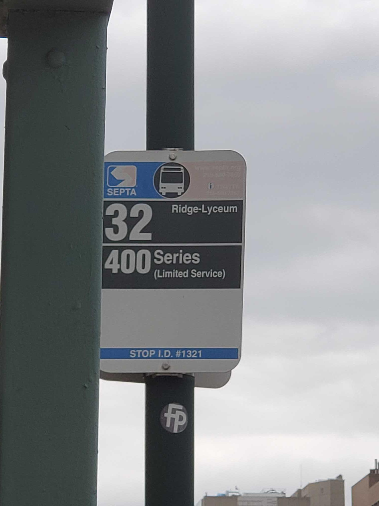
- 32, Ridge-Lyceum Via Lemon Hill,
- 2, 20th-Johnston,
- 49, 33rd-Dauphin,
- 38, 5th-Market,
What are the closest stations to Vine St & 19th St?
The closest stations to Vine St & 19th St are:
- 19th St & Vine St stop is 78 yards away, 2 min walk.
- Vine St & 20th St stop is 152 yards away, 2 min walk.
- 17th St & Race St stop is 214 yards away, 3 min walk.
- 20th St & Wood St stop is 223 yards away, 3 min walk.
- Suburban Station is 230 yards away, 3 min walk.
- 19th St station is 284 yards away, 6 min walk.
- Ben Franklin Pkwy & 20th St stop is 353 yards away, 5 min walk.
- Race Vine Station - Bsl is 498 yards away, 7 min walk.
Which bus lines stop near Vine St & 19th St?
These bus lines stop near Vine St & 19th St: 16, 2, 32, 33, 44, 49, QUEEN LANE (EAST FALLS LOOP).
Which train lines stop near Vine St & 19th St?
These train lines stop near Vine St & 19th St: CHE, CHW, LAN, MED, NOR, TRE.
Which metro lines stop near Vine St & 19th St?
These metro lines stop near Vine St & 19th St: B1, B2, L1.
What’s the nearest metro station to Vine St & 19th St in Philadelphia?
The nearest metro station to Vine St & 19th St in Philadelphia is 19th St. It’s a 6 min walk away.
What’s the nearest train station to Vine St & 19th St in Philadelphia?
The nearest train station to Vine St & 19th St in Philadelphia is Suburban Station. It’s a 3 min walk away.
What’s the nearest bus station to Vine St & 19th St in Philadelphia?
The nearest bus stations to Vine St & 19th St in Philadelphia are 19th St & Vine St and Vine St & 20th St. The closest one is a 2 min walk away.
Vine St & 19th St station
 Taken by Anonymous
See Vine St & 19th St stop, Philadelphia, on the map
Public transit to Vine St & 19th St stop (ID: 1321) in Philadelphia
Looking for directions to Vine St & 19th St in Philadelphia, United States?
Download the Moovit App to find the current schedule and step-by-step directions for Bus, Metro or Train routes that pass through Vine St & 19th St.
Looking for the nearest stops closest to Vine St & 19th St ? Check out this list of closest stops to your destination: 19th St & Vine St; Vine St & 20th St; 17th St & Race St ; 20th St & Wood St; Suburban Station; 19th St; Ben Franklin Pkwy & 20th St; Race Vine Station - Bsl.
Bus: 16, 2, 32, 33, 44, 49, QUEEN LANE (EAST FALLS LOOP).Train: CHE, CHW, LAN, MED, NOR, TRE, AIR, CYN, FOX.Metro: B1, B2, L1, T1, T2, T3, T4, T5.
We make riding on public transit to Vine St & 19th St easy, which is why over 1.7 billion users, including users in Philadelphia trust Moovit as the best app for public transit.
Use the app to navigate to popular places including to the airport, hospital, stadium, grocery store, mall, coffee shop, school, college, and university.
Vine St & 19th St stop’s code is 1321
The first line to this stop is 32, at 5:49 AM, and the last line is 32 at 1:34 AM.
1801 Vine Street, Philadelphia, PA, USA
This stop serves SEPTA’s lines
- 19th St & Vine St,
- Vine St & 20th St,
- 17th St & Race St ,
- 20th St & Wood St,
- Ben Franklin Pkwy & 20th St
Bus stops near Vine St & 19th St stop
- Suburban Station
Train station near Vine St & 19th St station
- 19th St,
- Race Vine Station - Bsl
Metro stations near Vine St & 19th St station
- Bustleton Av & Southampton Rd,
- Arch St & 5th St,
- 17th St & Montgomery Av,
- Red Lion Rd & Knights Rd ,
- 16th St & Locust St ,
- 22nd St & Dauphin St,
- Market St & 6th St,
- 17th St & Walnut St ,
- 9th St & Hunting Park Av,
- Gulph Mills,
- Broad St & Front St,
- Florence River Line Station,
- 12th St & Market St ,
- 37th-Spruce,
- Broad St & Porter St,
- Mall Blvd & Court Blvd - FS,
- JFK Blvd & 17th St,
- 36th-Sansom,
- Coventry Mall,
- Academy Rd & Woodhaven Rd
Popular public transit stations in Philadelphia
Get around Philadelphia by public transit!
Traveling around Philadelphia has never been so easy. See step by step directions as you travel to any attraction, street or major public transit station. View bus and train schedules, arrival times, service alerts and detailed routes on a map, so you know exactly how to get to anywhere in Philadelphia.
When traveling to any destination around Philadelphia use Moovit's Live Directions with Get Off Notifications to know exactly where and how far to walk, how long to wait for your line, and how many stops are left. Moovit will alert you when it's time to get off — no need to constantly re-check whether yours is the next stop.
Wondering how to use public transit in Philadelphia or how to pay for public transit in Philadelphia? Moovit public transit app can help you navigate your way with public transit easily, and at minimum cost. It includes public transit fees, ticket prices, and costs. Looking for a map of Philadelphia public transit lines? Moovit public transit app shows all public transit maps in Philadelphia with all Bus, Train, Metro, Light Rail and Cable Car routes and stops on an interactive map.
Philadelphia has 5 transit type(s), including: Bus, Train, Metro, Light Rail and Cable Car, operated by several transit agencies, including SEPTA Subway, SEPTA Rail, SEPTA, SEPTA Trolley, NJ Transit Rail, NJ Transit, Port Authority Transit Corporation, Navy Yard, Penn Transit, Drexel University, Pottstown Area Rapid Transit (PART), Fullington Tours, Chescobus, Amtrak and Greyhound-us