Directions to WESTERN UNION (Washington, D.C. - Baltimore, MD) with public transportation
The following transit lines have routes that pass near WESTERN UNION
 Bus: SMART WAY EXPRESS, SWB, TCP, UCB, HWC.
How to get to WESTERN UNION by bus?
Click on the bus route to see step by step directions with maps, line arrival times and updated time schedules.
Bus stops near WESTERN UNION in Washington, D.C. - Baltimore, MD
Bus lines to WESTERN UNION in Washington, D.C. - Baltimore, MD
What are the closest stations to WESTERN UNION?
The closest stations to WESTERN UNION are:
- Toms Creek/Winston Nbnd is 57 yards away, 1 min walk.
- University Mall Nbnd is 89 yards away, 2 min walk.
- Prices Fork/Old Glade Ebnd is 563 yards away, 7 min walk.
- Orange Bay 16 is 598 yards away, 8 min walk.
Which bus lines stop near WESTERN UNION?
These bus lines stop near WESTERN UNION: SMART WAY EXPRESS, SWB.
What’s the nearest bus station to WESTERN UNION in Washington, D.C. - Baltimore, MD?
The nearest bus station to WESTERN UNION in Washington, D.C. - Baltimore, MD is Toms Creek/Winston Nbnd. It’s a 1 min walk away.
What time is the first bus to WESTERN UNION in Washington, D.C. - Baltimore, MD?
The CRC is the first bus that goes to WESTERN UNION in Washington, D.C. - Baltimore, MD. It stops nearby at 7:00 AM.
What time is the last bus to WESTERN UNION in Washington, D.C. - Baltimore, MD?
The UCB is the last bus that goes to WESTERN UNION in Washington, D.C. - Baltimore, MD. It stops nearby at 9:45 PM.
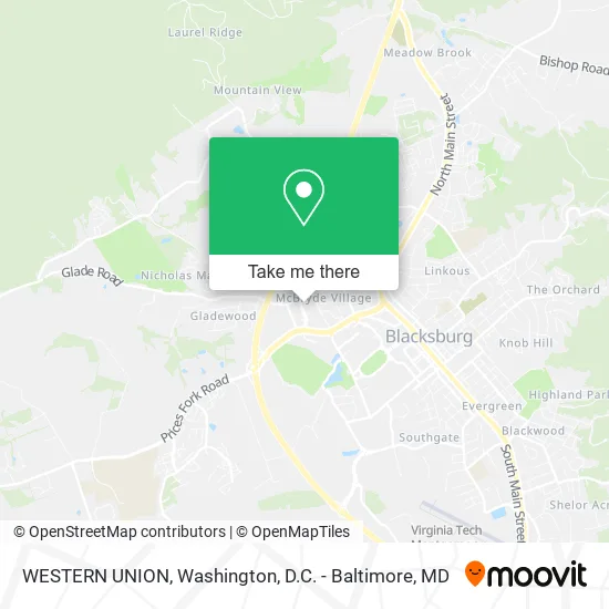
See WESTERN UNION, Washington, D.C. - Baltimore, MD, on the map
Public Transit to WESTERN UNION in Washington, D.C. - Baltimore, MD
Wondering how to get to WESTERN UNION in Washington, D.C. - Baltimore, MD? Moovit helps you find the best way to get to WESTERN UNION with step-by-step directions from the nearest public transit station.
Moovit provides free maps and live directions to help you navigate through your city. View schedules, routes, timetables, and find out how long does it take to get to WESTERN UNION in real time.
Looking for the nearest stop or station to WESTERN UNION? Check out this list of stops closest to your destination: Toms Creek/Winston Nbnd; University Mall Nbnd; Prices Fork/Old Glade Ebnd; Orange Bay 16.
Bus: SMART WAY EXPRESS, SWB, TCP, UCB, HWC, CRC.
Want to see if there’s another route that gets you there at an earlier time? Moovit helps you find alternative routes or times. Get directions from and directions to WESTERN UNION easily from the Moovit App or Website.
We make riding to WESTERN UNION easy, which is why over 1.5 million users, including users in Washington, D.C. - Baltimore, MD, trust Moovit as the best app for public transit. You don’t need to download an individual bus app or train app, Moovit is your all-in-one transit app that helps you find the best bus time or train time available.
For information on prices of bus and train, costs and ride fares to WESTERN UNION, please check the Moovit app.
Use the app to navigate to popular places including to the airport, hospital, stadium, grocery store, mall, coffee shop, school, college, and university.
WESTERN UNION Address: 850 University City Blvd Blacksburg, VA 24060 street in Washington, D.C. - Baltimore, MD
- Rite Aid,
- Outreach & International Affairs,
- Blacksburg Day Care,
- EV Charging Station,
- Kroger Fuel Center,
- Pointe West Commons,
- Office Of International Research & Development,
- Gaucho Grille,
- Kroger,
- English Language Institute,
- Lambda Instruments, Inc.,
- Allegiance Realty Partners Llc,
- Electrical Distribution Design, Inc.,
- Pocahontas Press, Inc.,
- Zeppoli's Italian Restaurant,
- Pizza Hut,
- Himalayan Curry Cafe,
- Skin Deep Medical Technologies,
- Caribbean Tan, Inc.,
- Blacksburg Center For Martial Arts
Places Near WESTERN UNION (Washington, D.C. - Baltimore, MD)
- National Theatre, Washington,
- Washington National Cathedral, Washington,
- Washington DC VA Medical Center, Washington,
- Museum Of The Bible, Washington,
- Basilica of the National Shrine, Washington,
- Amazon Hq2, Arlington County,
- PG Mall, Prince George's County,
- Camden Yards, Baltimore,
- Warner Theatre, Washington,
- M&T Bank Stadium, Baltimore,
- National Zoo, Washington,
- National Museum of African American History and Culture, Washington,
- The Anthem, Washington,
- Sibley Memorial Hospital, Washington,
- Marriott Marquis Washington, DC, Washington,
- Rock Creek Tennis Center, Washington,
- Pennsylvania Ave NW (3rd st and pennsylvania), Washington,
- Georgetown, Washington,
- Capital One Arena, Washington,
- Westfield Montgomery Mall, Montgomery County
How to get to popular places in Washington, D.C. - Baltimore, MD with public transit
Get around Washington, D.C. - Baltimore, MD by public transit!
Traveling around Washington, D.C. - Baltimore, MD has never been so easy. See step by step directions as you travel to any attraction, street or major public transit station. View bus and train schedules, arrival times, service alerts and detailed routes on a map, so you know exactly how to get to anywhere in Washington, D.C. - Baltimore, MD.
When traveling to any destination around Washington, D.C. - Baltimore, MD use Moovit's Live Directions with Get Off Notifications to know exactly where and how far to walk, how long to wait for your line, and how many stops are left. Moovit will alert you when it's time to get off — no need to constantly re-check whether yours is the next stop.
Wondering how to use public transit in Washington, D.C. - Baltimore, MD or how to pay for public transit in Washington, D.C. - Baltimore, MD? Moovit public transit app can help you navigate your way with public transit easily, and at minimum cost. It includes public transit fees, ticket prices, and costs. Looking for a map of Washington, D.C. - Baltimore, MD public transit lines? Moovit public transit app shows all public transit maps in Washington, D.C. - Baltimore, MD with all Bus, Train, Metro, Light Rail and Ferry routes and stops on an interactive map.
Washington, D.C. - Baltimore, MD has 5 transit type(s), including: Bus, Train, Metro, Light Rail and Ferry, operated by several transit agencies, including WMATA, Montgomery County Ride On, Fairfax Connector, TheBus, PRTC, DASH - Alexandria, Arlington Transit (ART), RTA of Central Maryland, MDOT MTA, MDOT MTA Light RailLink, MDOT MTA Commuter Bus, MDOT MTA Local Bus, FXBGO!, Virginia Railway Express (VRE) and MARC