W 49 St & W 12 Av stop - Monday schedule
| Line | Direction | Time |
|---|---|---|
| 103 | 103 - NE 79 St/Biscayne Blvd | 5:02 AM |
| 54 | 54a - Biscayne Blvd | 5:38 AM |
| 103 | 103 - NE 79 St/Biscayne Blvd | 5:39 AM |
| 54 | 54 - Biscayne Blvd | 6:00 AM |
| 103 | 103 - NE 79 St/Biscayne Blvd | 6:10 AM |
| 54 | 54a - Biscayne Blvd | 6:32 AM |
| HIAMAR | City Of Hialeah Transit (Marlin) | 6:40 AM |
| 103 | 103 - NE 79 St/Biscayne Blvd | 6:47 AM |
| 54 | 54 - Biscayne Blvd | 7:00 AM |
| HIAMAR | City Of Hialeah Transit (Marlin) | 7:17 AM |
| 103 | 103 - NE 79 St/Biscayne Blvd | 7:18 AM |
| 54 | 54a - Biscayne Blvd | 7:35 AM |
| HIAMAR | City Of Hialeah Transit (Marlin) | 7:49 AM |
| 103 | 103 - NE 79 St/Biscayne Blvd | 7:50 AM |
| 54 | 54 - Biscayne Blvd | 8:05 AM |
| 103 | 103 - NE 79 St/Biscayne Blvd | 8:21 AM |
| HIAMAR | City Of Hialeah Transit (Marlin) | 8:22 AM |
| 54 | 54a - Biscayne Blvd | 8:35 AM |
| 103 | 103 - NE 79 St/Biscayne Blvd | 8:53 AM |
| 54 | 54 - Biscayne Blvd | 9:08 AM |
| HIAMAR | City Of Hialeah Transit (Marlin) | 9:09 AM |
| 103 | 103 - NE 79 St/Biscayne Blvd | 9:25 AM |
| 54 | 54a - Biscayne Blvd | 9:37 AM |
| HIAMAR | City Of Hialeah Transit (Marlin) | 9:52 AM |
| 103 | 103 - NE 79 St/Biscayne Blvd | 9:56 AM |
Directions to W 49 St & W 12 Av stop (Hialeah) with public transit
The following transit lines have routes that pass near W 49 St & W 12 Av
 Bus: 103, 183, 54, HIAMAR.
- Train: GREEN.
How to get to W 49 St & W 12 Av stop by bus?
Click on the bus route to see step by step directions with maps, line arrival times and updated time schedules.
How to get to W 49 St & W 12 Av stop by train?
Click on the train route to see step by step directions with maps, line arrival times and updated time schedules.
Bus stops near W 49 St & W 12 Av stop in Hialeah
- W 12 Av & 49 St Hialeah, 2 min walk,
- W 49 St & W 12 Av, 3 min walk,
Train stations near W 49 St & W 12 Av station in Hialeah
- Okeechobee, 30 min walk,
Bus lines to W 49 St & W 12 Av stop in Hialeah
- 183, 183 - Okeechobee Station,
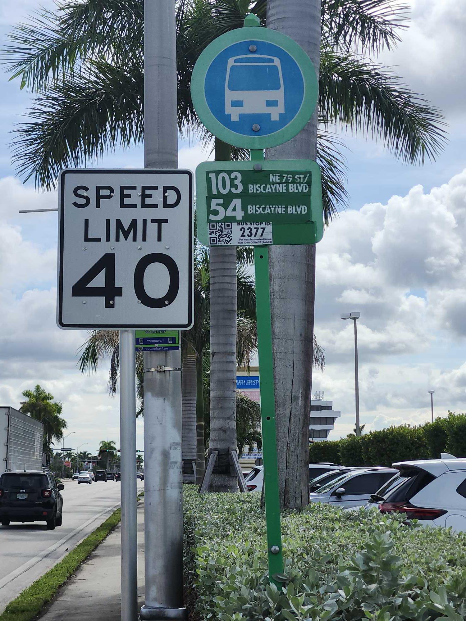
- 54, 54a - Biscayne Blvd,
- 103, 103 - H. Gardens Okeechobee Rd/87 Av,
- HIAMAR, City Of Hialeah Transit (Marlin),
What are the closest stations to W 49 St & W 12 Av?
The closest stations to W 49 St & W 12 Av are:
- W 12 Av & 49 St Hialeah is 127 yards away, 2 min walk.
- W 49 St & W 12 Av is 183 yards away, 3 min walk.
- Okeechobee is 2497 yards away, 30 min walk.
Which bus lines stop near W 49 St & W 12 Av?
These bus lines stop near W 49 St & W 12 Av: 103, 183, 54, HIAMAR.
Which train line stops near W 49 St & W 12 Av?
GREEN (Dadeland South Stat.rail Northbound→Palmetto Station Rail Northbound)
What’s the nearest train station to W 49 St & W 12 Av in Hialeah?
The nearest train station to W 49 St & W 12 Av in Hialeah is Okeechobee. It’s a 30 min walk away.
What’s the nearest bus station to W 49 St & W 12 Av in Hialeah?
The nearest bus station to W 49 St & W 12 Av in Hialeah is W 12 Av & 49 St Hialeah. It’s a 2 min walk away.
W 49 St & W 12 Av station
 Taken by Roberto G.
See W 49 St & W 12 Av stop, Hialeah, on the map
Public transit to W 49 St & W 12 Av stop (ID: W49S#126) in Hialeah
Looking for directions to W 49 St & W 12 Av in Hialeah, United States?
Download the Moovit App to find the current schedule and step-by-step directions for Bus or Train routes that pass through W 49 St & W 12 Av.
Looking for the nearest stops closest to W 49 St & W 12 Av ? Check out this list of closest stops to your destination: W 12 Av & 49 St Hialeah; W 49 St & W 12 Av; Okeechobee.
Bus: 103, 183, 54, HIAMAR.Train: GREEN.
We make riding on public transit to W 49 St & W 12 Av easy, which is why over 1.5 million users, including users in Hialeah trust Moovit as the best app for public transit.
Use the app to navigate to popular places including to the airport, hospital, stadium, grocery store, mall, coffee shop, school, college, and university.
W 49 St & W 12 Av stop’s code is W49S#126
The first line to this stop is 103, at 5:02 AM, and the last line is 54 at 12:00 AM.
This stop serves Miami-Dade Transit’s lines
Popular routes from W 49 St & W 12 Av stop, Hialeah
- W 12 Av & 49 St Hialeah,
- W 49 St & W 12 Av
Bus stops near W 49 St & W 12 Av stop
- Okeechobee
Train station near W 49 St & W 12 Av station
- Brickell Station (West Side),
- Sw 40 St @ Sw 112 Av,
- Nw 7 St & 22 Av,
- 6TH AVE S at DIXIE HWY,
- Sw 137 Av @ Sw 160 St,
- Transitway & Sw 324 St,
- PURDY LN at MILITARY TRL,
- Sw 147 Av & Sw 288 St,
- Commercial Boulevard/Dixie Highway,
- Doral Center (Walgreens) Nw 97 Ave@nw 41 St,
- Lucy St@krome Av,
- Marathon - BB&T,
- Indian Creek & 43 St,
- Brickell Station (East Side),
- Collins Av & 18 St,
- WELLINGTON GREEN DR at PNR,
- Brickell,
- Dixie Highway/Northeast 6th Street,
- W Flagler St & Nw 43 Pl,
- Sw 124 Av @ Sw 152 St
Popular public transit stations in Hialeah
Get around Hialeah by public transit!
Traveling around Hialeah has never been so easy. See step by step directions as you travel to any attraction, street or major public transit station. View bus and train schedules, arrival times, service alerts and detailed routes on a map, so you know exactly how to get to anywhere in Hialeah.
When traveling to any destination around Hialeah use Moovit's Live Directions with Get Off Notifications to know exactly where and how far to walk, how long to wait for your line, and how many stops are left. Moovit will alert you when it's time to get off — no need to constantly re-check whether yours is the next stop.
Wondering how to use public transit in Hialeah or how to pay for public transit in Hialeah? Moovit public transit app can help you navigate your way with public transit easily, and at minimum cost. It includes public transit fees, ticket prices, and costs. Looking for a map of Hialeah public transit lines? Moovit public transit app shows all public transit maps in Hialeah with all Bus, Train, Light Rail and Ferry routes and stops on an interactive map.
Miami has 4 transit type(s), including: Bus, Train, Light Rail and Ferry, operated by several transit agencies, including Broward County Transit, Miami-Dade Transit, Metrorail, Palm Tran, Tri-Rail, Brightline, MARTY, City of Homestead Trolley, Key West Transit, Treasure Coast Connector, GoLine IRT, Amtrak, Greyhound-us, FlixBus-us and Aventura Express Shuttle Bus