W Flagler St @ Nw 16 Av stop - Friday schedule
| Line | Direction | Time |
|---|---|---|
| 11 | 11- Fiu South Terminal | 5:03 AM |
| 211 | 211 - Sweetwater Flagler St/107 Av | 5:13 AM |
| 211 | 211 - Sweetwater Flagler St/107 Av | 5:28 AM |
| 11 | 11- Fiu South Terminal | 5:38 AM |
| 211 | 211 - Sweetwater Flagler St/107 Av | 5:43 AM |
| 11 | 11- Fiu South Terminal | 5:48 AM |
| 211 | 211 - Sweetwater Flagler St/107 Av | 5:58 AM |
| 11 | 11- Fiu South Terminal | 6:04 AM |
| 211 | 211 - Sweetwater Flagler St/107 Av | 6:14 AM |
| 208 | 208 - Via SW 8 St/Flagler St | 6:18 AM |
| 11 | 11- Fiu South Terminal | 6:22 AM |
| 211 | 211 - Sweetwater Flagler St/107 Av | 6:29 AM |
| 208 | 208 - Via SW 8 St/Flagler St | 6:33 AM |
| 11 | 11- Fiu South Terminal | 6:39 AM |
| 211 | 211 - Sweetwater Flagler St/107 Av | 6:44 AM |
| 208 | 208 - Via SW 8 St/Flagler St | 6:48 AM |
| 11 | 11- Fiu South Terminal | 6:49 AM |
| MIAHAVA | Little Havana Route | 6:53 AM |
| 211 | 211 - Sweetwater Flagler St/107 Av | 6:59 AM |
| 11 | 11- Fiu South Terminal | 6:59 AM |
| 208 | 208 - Via SW 8 St/Flagler St | 7:03 AM |
| MIAHAVA | Little Havana Route | 7:08 AM |
| 11 | 11- Fiu South Terminal | 7:09 AM |
| 211 | 211 - Sweetwater Flagler St/107 Av | 7:15 AM |
| 11 | 11- Fiu South Terminal | 7:19 AM |
Directions to W Flagler St @ Nw 16 Av stop (Miami) with public transit
The following transit lines have routes that pass near W Flagler St @ Nw 16 Av
 Bus: 11, 17, 208, 211, MIAHAVA.
- Train: GREEN, ORANGE, TRIRAIL, TRIRAIL.
How to get to W Flagler St @ Nw 16 Av stop by bus?
Click on the bus route to see step by step directions with maps, line arrival times and updated time schedules.
How to get to W Flagler St @ Nw 16 Av stop by train?
Click on the train route to see step by step directions with maps, line arrival times and updated time schedules.
Bus stops near W Flagler St @ Nw 16 Av stop in Miami
- W Flagler St@nw 15 Av, 3 min walk,
- Sw 1 St @ Sw 18 Av, 3 min walk,
- Sw 17 Av & Sw 3 St, 4 min walk,
- W Flagler St @ Nw 18 Av, 5 min walk,
- Sw 1 St @ Sw 17 Av, 7 min walk,
Train stations near W Flagler St @ Nw 16 Av station in Miami
- Santa Clara, 33 min walk,
- MiamiCentral Station, 36 min walk,
Light Rail stations near W Flagler St @ Nw 16 Av station in Miami
- Government Center Station, 41 min walk,
Bus lines to W Flagler St @ Nw 16 Av stop in Miami
- MIAHAVA, Little Havana Route,
- MIASTA, Stadium Route,
- 11, 11 - Downtown Miami,
- 207, 207 - Via SW 7 St/1 St,
- 17, 17 - 163 St Mall Terminal,
- 208, 208 - Via SW 8 St/Flagler St,
- 211, 211 - Downtown Miami,
What are the closest stations to W Flagler St @ Nw 16 Av?
The closest stations to W Flagler St @ Nw 16 Av are:
- W Flagler St@nw 15 Av stop is 229 yards away, 3 min walk.
- Sw 1 St @ Sw 18 Av stop is 238 yards away, 3 min walk.
- Sw 17 Av & Sw 3 St stop is 273 yards away, 4 min walk.
- W Flagler St @ Nw 18 Av stop is 376 yards away, 5 min walk.
- Sw 1 St @ Sw 17 Av stop is 534 yards away, 7 min walk.
- Santa Clara station is 2805 yards away, 33 min walk.
- MiamiCentral Station is 3100 yards away, 36 min walk.
- Government Center Station is 3551 yards away, 41 min walk.
Which bus lines stop near W Flagler St @ Nw 16 Av?
These bus lines stop near W Flagler St @ Nw 16 Av: 11, 17, 208, 211, MIAHAVA.
Which train line stops near W Flagler St @ Nw 16 Av?
GREEN (Palmetto Station Rail Southbound→Dadeland South Stat.rail Southbound)
What’s the nearest bus station to W Flagler St @ Nw 16 Av in Miami?
The nearest bus stations to W Flagler St @ Nw 16 Av in Miami are W Flagler St@nw 15 Av and Sw 1 St @ Sw 18 Av. The closest one is a 3 min walk away.
What time is the first light rail to W Flagler St @ Nw 16 Av in Miami?
The MMI is the first light rail that goes to W Flagler St @ Nw 16 Av in Miami. It stops nearby at 5:30 AM.
What time is the last light rail to W Flagler St @ Nw 16 Av in Miami?
The MMO is the last light rail that goes to W Flagler St @ Nw 16 Av in Miami. It stops nearby at 10:12 PM.
What time is the first train to W Flagler St @ Nw 16 Av in Miami?
The ORANGE is the first train that goes to W Flagler St @ Nw 16 Av in Miami. It stops nearby at 5:12 AM.
What time is the last train to W Flagler St @ Nw 16 Av in Miami?
The GREEN is the last train that goes to W Flagler St @ Nw 16 Av in Miami. It stops nearby at 12:44 AM.
What time is the first bus to W Flagler St @ Nw 16 Av in Miami?
The 11 is the first bus that goes to W Flagler St @ Nw 16 Av in Miami. It stops nearby at 3:14 AM.
What time is the last bus to W Flagler St @ Nw 16 Av in Miami?
The 11 is the last bus that goes to W Flagler St @ Nw 16 Av in Miami. It stops nearby at 2:39 AM.
W Flagler St @ Nw 16 Av station
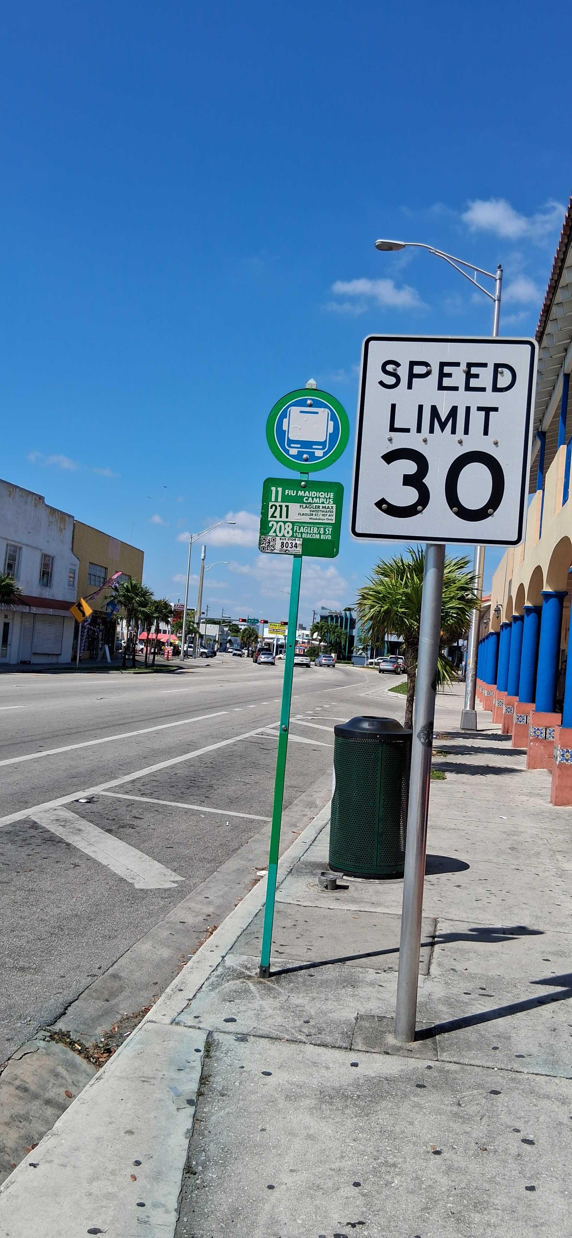 Taken by Anonymous
See W Flagler St @ Nw 16 Av stop, Miami, on the map
Public transit to W Flagler St @ Nw 16 Av stop (ID: WFLG#168) in Miami
Looking for directions to W Flagler St @ Nw 16 Av in Miami, United States?
Download the Moovit App to find the current schedule and step-by-step directions for Bus or Train routes that pass through W Flagler St @ Nw 16 Av.
Looking for the nearest stops closest to W Flagler St @ Nw 16 Av ? Check out this list of closest stops to your destination: W Flagler St@nw 15 Av; Sw 1 St @ Sw 18 Av; Sw 17 Av & Sw 3 St; W Flagler St @ Nw 18 Av; Sw 1 St @ Sw 17 Av; Santa Clara; MiamiCentral Station; Government Center Station.
Bus: 11, 17, 208, 211, MIAHAVA, MIASTA, 207.Train: GREEN, ORANGE, TRIRAIL, TRIRAIL.
We make riding on public transit to W Flagler St @ Nw 16 Av easy, which is why over 1.7 billion users, including users in Miami trust Moovit as the best app for public transit.
Use the app to navigate to popular places including to the airport, hospital, stadium, grocery store, mall, coffee shop, school, college, and university.
W Flagler St @ Nw 16 Av stop’s code is WFLG#168
The first line to this stop is 11, at 5:03 AM, and the last line is 11 at 4:13 AM.
This stop serves Miami-Dade Transit’s lines
Popular routes from W Flagler St @ Nw 16 Av stop, Miami
- W Flagler St@nw 15 Av,
- Sw 1 St @ Sw 18 Av,
- Sw 17 Av & Sw 3 St,
- W Flagler St @ Nw 18 Av,
- Sw 1 St @ Sw 17 Av
Bus stops near W Flagler St @ Nw 16 Av stop
- Santa Clara,
- MiamiCentral Station
Train stations near W Flagler St @ Nw 16 Av station
- Government Center Station
Light Rail station near W Flagler St @ Nw 16 Av station
- Riverside Drive/Northwest 44th Court,
- Nw 72 Av & Nw 74 St,
- Nw 87 Ct & 114 St,
- GLADES RD at BOCA RIO RD,
- Truman Waterfront Park- Water Park Area,
- W Flagler St & Nw 43 Av,
- Oakland Park Boulevard/A1A,
- Collins Av & 43 St,
- TAMARIND AVE at PALM BCH LAKES BLVD,
- Gardenia Ave & US Hwy 1,
- US 441/Washington South,
- Nw 27 Av & 113 St,
- Indian Creek & 43 St,
- Biscayne Bd @ Ne 25 St,
- Truman & Simonton,
- Cudjoe Key - Opposite Coco's Cantina,
- CRESTHAVEN at MILITARY TRL,
- Sw 124 Av @ Sw 152 St,
- Palmetto General Hospital,
- US 1/Broward Boulevard
Popular public transit stations in Miami
Get around Miami by public transit!
Traveling around Miami has never been so easy. See step by step directions as you travel to any attraction, street or major public transit station. View bus and train schedules, arrival times, service alerts and detailed routes on a map, so you know exactly how to get to anywhere in Miami.
When traveling to any destination around Miami use Moovit's Live Directions with Get Off Notifications to know exactly where and how far to walk, how long to wait for your line, and how many stops are left. Moovit will alert you when it's time to get off — no need to constantly re-check whether yours is the next stop.
Wondering how to use public transit in Miami or how to pay for public transit in Miami? Moovit public transit app can help you navigate your way with public transit easily, and at minimum cost. It includes public transit fees, ticket prices, and costs. Looking for a map of Miami public transit lines? Moovit public transit app shows all public transit maps in Miami with all Bus, Train, Light Rail and Ferry routes and stops on an interactive map.
Miami has 4 transit type(s), including: Bus, Train, Light Rail and Ferry, operated by several transit agencies, including Broward County Transit, Miami-Dade Transit, Metrorail, Palm Tran, Tri-Rail, Brightline, MARTY, City of Homestead Trolley, Key West Transit, Treasure Coast Connector, GoLine IRT, Amtrak, Greyhound-us, FlixBus-us and Aventura Express Shuttle Bus