How to get to Walgreens by bus?
Click on the bus route to see step by step directions with maps, line arrival times and updated time schedules.
From Pentagon Library and Conference Center, Arlington County
64 minFrom Knollwood, Washington
75 minFrom Holy Cross Hospital, Montgomery County
62 minFrom Washington Hebrew Congregation, Washington
62 minFrom Sheraton-Pentagon City Hotel (Sheraton Arlington), Arlington County
85 minFrom Sheraton Pentagon City Hotel, Arlington County
85 minFrom Embassy of The Federal Republic of Germany, Washington
47 minFrom New Carrollton MARC, Prince George's County
52 minFrom C&O Canal Towpath, Washington
83 minFrom Wilson Blvd, Arlington County
68 min
How to get to Walgreens by metro?
Click on the metro route to see step by step directions with maps, line arrival times and updated time schedules.
From Pentagon Library and Conference Center, Arlington County
48 minFrom Holy Cross Hospital, Montgomery County
41 minFrom Washington Hebrew Congregation, Washington
63 minFrom Sheraton-Pentagon City Hotel (Sheraton Arlington), Arlington County
65 minFrom Sheraton Pentagon City Hotel, Arlington County
64 minFrom Embassy of The Federal Republic of Germany, Washington
48 minFrom New Carrollton MARC, Prince George's County
62 minFrom Wilson Blvd, Arlington County
53 min
Bus stops near Walgreens in Washington
Metro stations near Walgreens in Washington
Bus lines to Walgreens in Washington
What are the closest stations to Walgreens?
The closest stations to Walgreens are:
- Rhode Island Av Ne+Franklin St NE is 59 yards away, 1 min walk.
- Franklin St Ne+15 St NE is 160 yards away, 3 min walk.
- Rhode Island Av Ne+Montana Av NE is 202 yards away, 3 min walk.
- Shaw-Howard U Metro Station is 816 yards away, 10 min walk.
- Fort Totten is 1844 yards away, 22 min walk.
Which bus lines stop near Walgreens?
These bus lines stop near Walgreens: C63, D32, P10, P40.
Which metro line stops near Walgreens?
RED (Glenmont)
What’s the nearest metro station to Walgreens in Washington?
The nearest metro station to Walgreens in Washington is Shaw-Howard U Metro Station. It’s a 10 min walk away.
What’s the nearest bus station to Walgreens in Washington?
The nearest bus station to Walgreens in Washington is Rhode Island Av Ne+Franklin St NE. It’s a 1 min walk away.
What time is the first metro to Walgreens in Washington?
The GREEN is the first metro that goes to Walgreens in Washington. It stops nearby at 5:11 AM.
What time is the last metro to Walgreens in Washington?
The GREEN is the last metro that goes to Walgreens in Washington. It stops nearby at 12:30 AM.
What time is the first bus to Walgreens in Washington?
The D40 is the first bus that goes to Walgreens in Washington. It stops nearby at 3:13 AM.
What time is the last bus to Walgreens in Washington?
The D40 is the last bus that goes to Walgreens in Washington. It stops nearby at 2:53 AM.
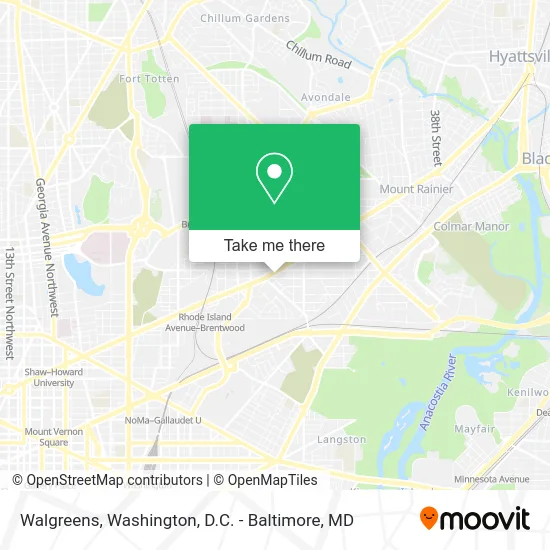
See Walgreens, Washington, on the map
Public Transit to Walgreens in Washington
Wondering how to get to Walgreens in Washington? Moovit helps you find the best way to get to Walgreens with step-by-step directions from the nearest public transit station.
Moovit provides free maps and live directions to help you navigate through your city. View schedules, routes, timetables, and find out how long does it take to get to Walgreens in real time.
Looking for the nearest stop or station to Walgreens? Check out this list of stops closest to your destination: Rhode Island Av Ne+Franklin St NE; Franklin St Ne+15 St NE; Rhode Island Av Ne+Montana Av NE; Shaw-Howard U Metro Station; Fort Totten.
Bus: C63, D32, P10, P40, P1X.Metro: RED, GREEN, YELLOW.
Want to see if there’s another route that gets you there at an earlier time? Moovit helps you find alternative routes or times. Get directions from and directions to Walgreens easily from the Moovit App or Website.
We make riding to Walgreens easy, which is why over 1.5 million users, including users in Washington, trust Moovit as the best app for public transit. You don’t need to download an individual bus app or train app, Moovit is your all-in-one transit app that helps you find the best bus time or train time available.
For information on prices of bus and metro, costs and ride fares to Walgreens, please check the Moovit app.
Use the app to navigate to popular places including to the airport, hospital, stadium, grocery store, mall, coffee shop, school, college, and university.
Walgreens Address: 1401 Rhode Island Ave NE Washington, DC 20018 street in Washington
- Franklin,
- Capital Bikeshare,
- Douglas Montana,
- Adventure Dental and Vision (Adventure Dental of Washington DC),
- 17th St NE and Franklin St,
- dc public library - Woodbridge,
- Ledo Pizza,
- Woodridge Neighborhood Library,
- Ming Li's Happy Endings Massage Parlor,
- Capital City Hall of Distinction,
- District of Columbia Public Schools,
- Tunup Squad Entertainment,
- Langdon Park east Recreation Center,
- Brentwood Road Test Facility (DC DMV Road Test Office),
- 2315 18th Pl NE ,
- Happy Valley Produce,
- CCC Majemu Parish,
- Langdon Park Community Center,
- The Home Depot,
- Tastemakers
Places Near Walgreens (Washington)
- Washington National Cathedral, Washington,
- Washington DC VA Medical Center, Washington,
- Museum Of The Bible, Washington,
- M&T Bank Stadium, Baltimore,
- Pennsylvania Ave NW (3rd st and pennsylvania), Washington,
- Basilica of the National Shrine, Washington,
- Westfield Montgomery Mall, Montgomery County,
- Amazon Hq2, Arlington County,
- Camden Yards, Baltimore,
- National Museum of African American History and Culture, Washington,
- PG Mall, Prince George's County,
- Sibley Memorial Hospital, Washington,
- National Zoo, Washington,
- Warner Theatre, Washington,
- Rock Creek Tennis Center, Washington,
- National Theatre, Washington,
- The Anthem, Washington,
- Marriott Marquis Washington, DC, Washington,
- Capital One Arena, Washington,
- Georgetown, Washington
How to get to popular places in Washington, D.C. - Baltimore, MD with public transit
Get around Washington by public transit!
Traveling around Washington has never been so easy. See step by step directions as you travel to any attraction, street or major public transit station. View bus and train schedules, arrival times, service alerts and detailed routes on a map, so you know exactly how to get to anywhere in Washington.
When traveling to any destination around Washington use Moovit's Live Directions with Get Off Notifications to know exactly where and how far to walk, how long to wait for your line, and how many stops are left. Moovit will alert you when it's time to get off — no need to constantly re-check whether yours is the next stop.
Wondering how to use public transit in Washington or how to pay for public transit in Washington? Moovit public transit app can help you navigate your way with public transit easily, and at minimum cost. It includes public transit fees, ticket prices, and costs. Looking for a map of Washington public transit lines? Moovit public transit app shows all public transit maps in Washington with all Bus, Train, Metro, Light Rail and Ferry routes and stops on an interactive map.
Washington, D.C. - Baltimore, MD has 5 transit type(s), including: Bus, Train, Metro, Light Rail and Ferry, operated by several transit agencies, including WMATA, Montgomery County Ride On, Fairfax Connector, TheBus, PRTC, DASH - Alexandria, Arlington Transit (ART), RTA of Central Maryland, MDOT MTA, MDOT MTA Light RailLink, MDOT MTA Commuter Bus, MDOT MTA Local Bus, FXBGO!, Virginia Railway Express (VRE) and MARC