Directions to Yesco Sign & Lighting Service (Indianapolis City (Balance)) with public transportation
The following transit lines have routes that pass near Yesco Sign & Lighting Service
 Bus: 82.
How to get to Yesco Sign & Lighting Service by bus?
Click on the bus route to see step by step directions with maps, line arrival times and updated time schedules.
From Soul Hitz Entertainment, Indianapolis City (Balance)
81 minFrom Fresh Thyme/The Coil Parking Garage, Indianapolis City (Balance)
56 minFrom Browning Craftsman Services, Indianapolis City (Balance)
79 minFrom N Franklin Rd / E 56th St, Lawrence
109 minFrom 46th Street & Emerson Avenue, Indianapolis City (Balance)
65 minFrom Clara K & Cartabella, Indianapolis City (Balance)
57 minFrom USPS Collection Box - Blue Box, Indianapolis City (Balance)
55 minFrom WESTERN UNION, Indianapolis City (Balance)
85 minFrom Highgarden Real Estate Indiana, Indianapolis City (Balance)
39 min
Bus stop near Yesco Sign & Lighting Service in Indianapolis City (Balance)
- 82nd St & Clearvista Pkwy, 5 min walk,VIEW
Bus lines to Yesco Sign & Lighting Service in Indianapolis City (Balance)
- 82, Glendale Town Center,VIEW
What are the closest stations to Yesco Sign & Lighting Service?
The closest stations to Yesco Sign & Lighting Service are:
- 82nd St & Clearvista Pkwy is 367 yards away, 5 min walk.
Which bus line stops near Yesco Sign & Lighting Service?
82 (Glendale Town Center)
What’s the nearest bus station to Yesco Sign & Lighting Service in Indianapolis City (Balance)?
The nearest bus station to Yesco Sign & Lighting Service in Indianapolis City (Balance) is 82nd St & Clearvista Pkwy. It’s a 5 min walk away.
What time is the first bus to Yesco Sign & Lighting Service in Indianapolis City (Balance)?
The 82 is the first bus that goes to Yesco Sign & Lighting Service in Indianapolis City (Balance). It stops nearby at 5:01 AM.
What time is the last bus to Yesco Sign & Lighting Service in Indianapolis City (Balance)?
The 82 is the last bus that goes to Yesco Sign & Lighting Service in Indianapolis City (Balance). It stops nearby at 10:31 PM.
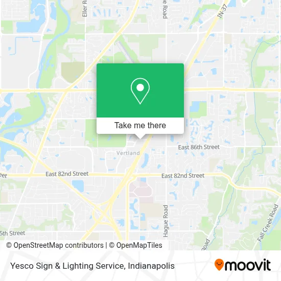
See Yesco Sign & Lighting Service, Indianapolis City (Balance), on the map
Public Transit to Yesco Sign & Lighting Service in Indianapolis City (Balance)
Wondering how to get to Yesco Sign & Lighting Service in Indianapolis City (Balance)? Moovit helps you find the best way to get to Yesco Sign & Lighting Service with step-by-step directions from the nearest public transit station.
Moovit provides free maps and live directions to help you navigate through your city. View schedules, routes, timetables, and find out how long does it take to get to Yesco Sign & Lighting Service in real time.
Looking for the nearest stop or station to Yesco Sign & Lighting Service? Check out this list of stops closest to your destination: 82nd St & Clearvista Pkwy.
Bus: 82.
Want to see if there’s another route that gets you there at an earlier time? Moovit helps you find alternative routes or times. Get directions from and directions to Yesco Sign & Lighting Service easily from the Moovit App or Website.
We make riding to Yesco Sign & Lighting Service easy, which is why over 1.5 million users, including users in Indianapolis City (Balance), trust Moovit as the best app for public transit. You don’t need to download an individual bus app or train app, Moovit is your all-in-one transit app that helps you find the best bus time or train time available.
For information on prices of bus, costs and ride fares to Yesco Sign & Lighting Service, please check the Moovit app.
Use the app to navigate to popular places including to the airport, hospital, stadium, grocery store, mall, coffee shop, school, college, and university.
Yesco Sign & Lighting Service Address: 7169 E 87th St Ste A street in Indianapolis City (Balance)
- Shadeland Ave & 82nd St,
- 82nd And Bash St,
- Hilton,
- Helipad CHN/in Heart,
- ATM,
- Dawes Fretzin Dermatology Group,
- Nebesio Chris L, MD,
- Sarah A Huseman Od,
- Internal Medicine Associates,
- Gretchen Cheuk-Wing Johnson, do,
- Starbucks,
- Worksite Clinic,
- ATM,
- Sahm Park / Castleton Recycling Bin,
- Construction & Devel,
- Scott Michael Sharp, MD,
- Brandon David Downing, MD, PHD,
- Dr Michael Venturini MD,
- Alumbaugh, Staci L,
- Patrick Ryan McGuire, do
Places Near Yesco Sign & Lighting Service (Indianapolis City (Balance))
- Methodist Hospital of Indianapolis, Indianapolis City (Balance),
- Castleton Square Mall, Indianapolis,
- Indiana Convention Center, Indianapolis City (Balance),
- THE BALT, Indianapolis City (Balance),
- Jersey Barn, Indianapolis City (Balance),
- St. Vincent entrance #1, Indianapolis City (Balance),
- Gainbridge Fieldhouse, Indianapolis City (Balance),
- Indiana, Indianapolis City (Balance),
- Eskenazi Hospital, Indianapolis City (Balance),
- Train Ride At Castleton Mall, Indianapolis City (Balance),
- Indianapolis Motor Speedway, Speedway,
- Lucas Oil Stadium, Indianapolis City (Balance),
- St. Vincent Hospital - Indianapolis, Indianapolis City (Balance),
- Cotter's Massage Parlor With Happy Endings, Indianapolis City (Balance),
- I-465 / I-65 Interchange, Indianapolis City (Balance),
- Plainfield, IN, Plainfield,
- 119 W 19th St Parking, Indianapolis City (Balance),
- I U Health Methodist Hospital, Indianapolis City (Balance),
- Indianapolis Airport Zone 2, Indianapolis City (Balance),
- Lilly Corporate Center (Eli Lilly & Co), Indianapolis City (Balance)
How to get to popular places in Indianapolis with public transit
Get around Indianapolis City (Balance) by public transit!
Traveling around Indianapolis City (Balance) has never been so easy. See step by step directions as you travel to any attraction, street or major public transit station. View bus and train schedules, arrival times, service alerts and detailed routes on a map, so you know exactly how to get to anywhere in Indianapolis City (Balance).
When traveling to any destination around Indianapolis City (Balance) use Moovit's Live Directions with Get Off Notifications to know exactly where and how far to walk, how long to wait for your line, and how many stops are left. Moovit will alert you when it's time to get off — no need to constantly re-check whether yours is the next stop.
Wondering how to use public transit in Indianapolis City (Balance) or how to pay for public transit in Indianapolis City (Balance)? Moovit public transit app can help you navigate your way with public transit easily, and at minimum cost. It includes public transit fees, ticket prices, and costs. Looking for a map of Indianapolis City (Balance) public transit lines? Moovit public transit app shows all public transit maps in Indianapolis City (Balance) with all bus routes and stops on an interactive map.
Indianapolis has 1 transit type(s), including: bus, operated by several transit agencies, including IndyGo, FlixBus-us and Greyhound-us