Directions to Young Women's College Preparatory Academy (Houston) with public transportation
The following transit lines have routes that pass near Young Women's College Preparatory Academy
How to get to Young Women's College Preparatory Academy by bus?
Click on the bus route to see step by step directions with maps, line arrival times and updated time schedules.
Bus stations near Young Women's College Preparatory Academy in Houston
- Wheeler Ave @ Chartres St,4 min walk,
- Almeda Rd @ Wheeler Ave,4 min walk,
Light Rail stations near Young Women's College Preparatory Academy in Houston
- Museum District (Southbound),20 min walk,
Bus lines to Young Women's College Preparatory Academy in Houston
- 25,Eastwood Tc - Eastbound,
- 11,Gellhorn & 610 - Northbound,
What are the closest stations to Young Women's College Preparatory Academy?
The closest stations to Young Women's College Preparatory Academy are:
- Wheeler Ave @ Chartres St is 269 yards away, 4 min walk.
- Almeda Rd @ Wheeler Ave is 290 yards away, 4 min walk.
- Museum District (Southbound) is 1650 yards away, 20 min walk.
Which bus lines stop near Young Women's College Preparatory Academy?
These bus lines stop near Young Women's College Preparatory Academy: 11, 25.
What’s the nearest light rail station to Young Women's College Preparatory Academy in Houston?
The nearest light rail station to Young Women's College Preparatory Academy in Houston is Museum District (Southbound). It’s a 20 min walk away.
What’s the nearest bus stop to Young Women's College Preparatory Academy in Houston?
The nearest bus stops to Young Women's College Preparatory Academy in Houston are Wheeler Ave @ Chartres St and Almeda Rd @ Wheeler Ave. The closest one is a 4 min walk away.
What time is the first light rail to Young Women's College Preparatory Academy in Houston?
The 700 is the first light rail that goes to Young Women's College Preparatory Academy in Houston. It stops nearby at 3:44 AM.
What time is the last light rail to Young Women's College Preparatory Academy in Houston?
The 700 is the last light rail that goes to Young Women's College Preparatory Academy in Houston. It stops nearby at 12:59 AM.
What time is the first bus to Young Women's College Preparatory Academy in Houston?
The 25 is the first bus that goes to Young Women's College Preparatory Academy in Houston. It stops nearby at 4:19 AM.
What time is the last bus to Young Women's College Preparatory Academy in Houston?
The 25 is the last bus that goes to Young Women's College Preparatory Academy in Houston. It stops nearby at 1:37 AM.
How much is the bus fare to Young Women's College Preparatory Academy?
The bus fare to Young Women's College Preparatory Academy costs about $1.25.
See Young Women's College Preparatory Academy, Houston, on the map
Public Transit to Young Women's College Preparatory Academy in Houston
Wondering how to get to Young Women's College Preparatory Academy in Houston, United States? Moovit helps you find the best way to get to Young Women's College Preparatory Academy with step-by-step directions from the nearest public transit station.
Moovit provides free maps and live directions to help you navigate through your city. View schedules, routes, timetables, and find out how long does it take to get to Young Women's College Preparatory Academy in real time.
Looking for the nearest stop or station to Young Women's College Preparatory Academy? Check out this list of stops closest to your destination: Wheeler Ave @ Chartres St; Almeda Rd @ Wheeler Ave; Museum District (Southbound).
Bus:1125
Want to see if there’s another route that gets you there at an earlier time? Moovit helps you find alternative routes or times. Get directions from and directions to Young Women's College Preparatory Academy easily from the Moovit App or Website.
We make riding to Young Women's College Preparatory Academy easy, which is why over 1.5 million users, including users in Houston, trust Moovit as the best app for public transit. You don’t need to download an individual bus app or train app, Moovit is your all-in-one transit app that helps you find the best bus time or train time available.
For information on prices of bus, costs and ride fares to Young Women's College Preparatory Academy, please check the Moovit app.
Use the app to navigate to popular places including to the airport, hospital, stadium, grocery store, mall, coffee shop, school, college, and university.
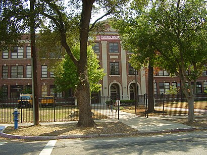
Young Women's College Preparatory Academy Address: Chenevert Street street in Houston
Attractions near Young Women's College Preparatory Academy
Houston Night High School ,Funding 4,Level One Fitness ,A Man & A Pickup Truck,Gigglin' Marlin Swim School,Quad Cigar Lounge (Quad Houston Rest),Shape Community Center (S.H.A.P.E. Community Center),Pioneer Dreams Eats (The Dog House Gourmet Hot Dogs & Eats),3rd Ward Art Institute,Solo Kutz,The Savoy,Central Region Cheers of Houston,Slapwoods,Advanced Chiropractic Clinic (Excellent Chiropractic Care),Vest Safety Medical Service,Third Ward,Awakenings Movement,Turkey Leg Hut,That Funnel Cake Place,The Woman's Earth Nurturing Studio (The Women's Earth)How to get to popular attractions in Houston with public transit
United Airlines In-Flight Training Center, Houston,Lupe Tortilla Mexican Restaurant, Houston,Woodforest National Bank, Houston,Pappasito's Cantina, Houston,US 59 & Bissonnet, Houston,Bechtel OG&C, Houston,I-45 & Almeda-Genoa, Houston,Clay & Beltway 8, Houston,IH 10 at Wilcrest, Houston,Almeda-Genoa Rd & 288 South Fwy, Houston,FM 1960 at Kuykendahl, Houston,Memorial Hermann Memorial City Medical Center, Houston,Chevron Corporation (1500 Louisiana), Houston,UH-Downtown Academic Building, Houston,Baytown, TX, Baytown,Beltway 8 & 249, Houston,Westheimer & Fountainview, Houston,288 South Freeway and Airport Blvd., Houston,Beltway 8 & Hwy 59, Houston,METRO Seton Lake Park & RideGet around Houston by public transit!
Traveling around Houston has never been so easy. See step by step directions as you travel to any attraction, street or major public transit station. View bus and train schedules, arrival times, service alerts and detailed routes on a map, so you know exactly how to get to anywhere in Houston.
When traveling to any destination around Houston use Moovit's Live Directions with Get Off Notifications to know exactly where and how far to walk, how long to wait for your line, and how many stops are left. Moovit will alert you when it's time to get off — no need to constantly re-check whether yours is the next stop.
Wondering how to use public transit in Houston or how to pay for public transit in Houston? Moovit public transit app can help you navigate your way with public transit easily, and at minimum cost. It includes public transit fees, ticket prices, and costs. Looking for a map of Houston public transit lines? Moovit public transit app shows all public transit maps in Houston with all bus routes and stops on an interactive map.
Houston has 1 transit type(s), including: bus, operated by several transit agencies, including METRO, METRO, Greyhound-us, FlixBus-us and Megabus