
1 Bus Route Map
View the 1 route map and see all 1 stops along the route. The map of 1 shows where the bus travels and the location of each stop, making it easy to understand the entire route at a glance.
Explore GoDurham routes on the map and see where GoDurham bus services operate. Use the 1 map to find bus stops and see how the 1 connects different areas along its trip.
All 1 stops on the map are displayed in route order, helping you follow the 1 bus from the first stop to the last.
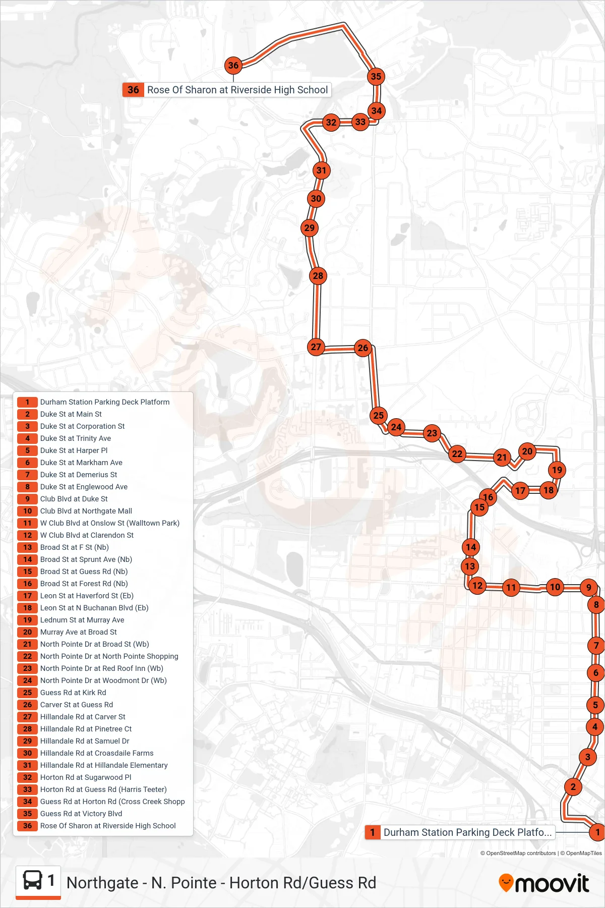
Stops list (1 - Riverside Hs)
- Durham Station Parking Deck Platform
- Duke St at Main St
- Duke St at Corporation St
- Duke St at Trinity Ave
- Duke St at Harper Pl
- Duke St at Markham Ave
- Duke St at Demerius St
- Duke St at Englewood Ave
- Club Blvd at Duke St
- Club Blvd at Northgate Mall
- W Club Blvd at Onslow St (Walltown Park)
- W Club Blvd at Clarendon St
- Broad St at F St (Nb)
- Broad St at Sprunt Ave (Nb)
- Broad St at Guess Rd (Nb)
- Broad St at Forest Rd (Nb)
- Leon St at Haverford St (Eb)
- Leon St at N Buchanan Blvd (Eb)
- Lednum St at Murray Ave
- Murray Ave at Broad St
- North Pointe Dr at Broad St (Wb)
- North Pointe Dr at North Pointe Shopping
- North Pointe Dr at Red Roof Inn (Wb)
- North Pointe Dr at Woodmont Dr (Wb)
- Guess Rd at Kirk Rd
- Carver St at Guess Rd
- Hillandale Rd at Carver St
- Hillandale Rd at Pinetree Ct
- Hillandale Rd at Samuel Dr
- Hillandale Rd at Croasdaile Farms
- Hillandale Rd at Hillandale Elementary
- Horton Rd at Sugarwood Pl
- Horton Rd at Guess Rd (Harris Teeter)
- Guess Rd at Horton Rd (Cross Creek Shopp
- Guess Rd at Victory Blvd
- Rose Of Sharon at Riverside High School