
1 Bus Route Map
View the 1 route map and see all 1 stops along the route. The map of 1 shows where the bus travels and the location of each stop, making it easy to understand the entire route at a glance.
Explore Stadtbus Schwäbisch Hall GmbH routes on the map and see where Stadtbus Schwäbisch Hall GmbH bus services operate. Use the 1 map to find bus stops and see how the 1 connects different areas along its trip.
All 1 stops on the map are displayed in route order, helping you follow the 1 bus from the first stop to the last.
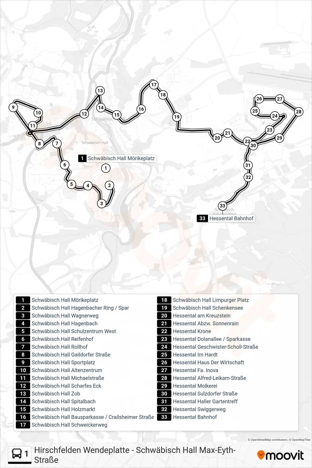
Stops list (1 - Hessental Bahnhof)
- Schwäbisch Hall Mörikeplatz
- Schwäbisch Hall Hagenbacher Ring / Spar
- Schwäbisch Hall Wagnerweg
- Schwäbisch Hall Hagenbach
- Schwäbisch Hall Schulzentrum West
- Schwäbisch Hall Reifenhof
- Schwäbisch Hall Rollhof
- Schwäbisch Hall Gaildorfer Straße
- Schwäbisch Hall Sportplatz
- Schwäbisch Hall Altenzentrum
- Schwäbisch Hall Michaelstraße
- Schwäbisch Hall Scharfes Eck
- Schwäbisch Hall Zob
- Schwäbisch Hall Spitalbach
- Schwäbisch Hall Holzmarkt
- Schwäbisch Hall Bausparkasse / Crailsheimer Straße
- Schwäbisch Hall Schweickerweg
- Schwäbisch Hall Limpurger Platz
- Schwäbisch Hall Schenkensee
- Hessental am Kreuzstein
- Hessental Abzw. Sonnenrain
- Hessental Krone
- Hessental Dolanallee / Sparkasse
- Hessental Geschwister-Scholl-Straße
- Hessental Im Hardt
- Hessental Haus Der Wirtschaft
- Hessental Fa. Inova
- Hessental Alfred-Leikam-Straße
- Hessental Molkerei
- Hessental Sulzdorfer Straße
- Hessental Haller Gartentreff
- Hessental Swiggerweg
- Hessental Bahnhof
Change direction
- Route Map - 1 - Schwäbisch Hall Hagenbacher Ring / Spar
- Route Map - 1 - Hirschfelden Wendeplatte
- Route Map - 1 - Sulzdorf Hauptstraße
- Route Map - 1 - Schwäbisch Hall Sportplatz
- Route Map - 1 - Michelbach An Der Bilz Kreuzung
- Route Map - 1 - Schwäbisch Hall Hagenbacher Ring / Berufsschulzentrum
- Route Map - 1 - Schwäbisch Hall Max-Eyth-Straße
- Route Map - 1 - Gailenkirchen Schule
- Route Map - 1 - Schwäbisch Hall Zob
- Route Map - 1 - Schwäbisch Hall Zob