
10 Bus Route Map
View the 10 route map and see all 10 stops along the route. The map of 10 shows where the bus travels and the location of each stop, making it easy to understand the entire route at a glance.
Explore ATMA S.c.p.a. routes on the map and see where ATMA S.c.p.a. bus services operate. Use the 10 map to find bus stops and see how the 10 connects different areas along its trip.
All 10 stops on the map are displayed in route order, helping you follow the 10 bus from the first stop to the last.
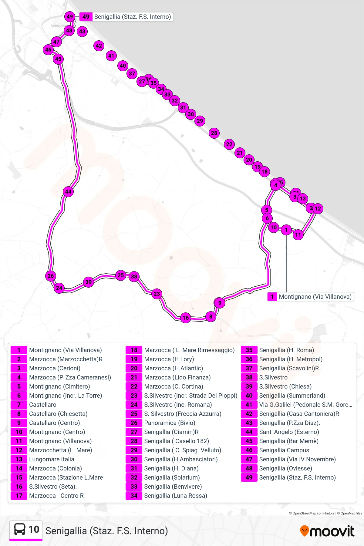
Stops list (10 - Senigallia (Railway Station Interior))
- Montignano (Villanova Street)
- Marzocca (Marzocchetta)R
- Marzocca (Cerioni)
- Marzocca (Cameranesi Square)
- Montignano (Cemetery)
- Montignano (La Torre Junction)
- Castellaro
- Castellaro (Little Church)
- Castellaro (Center)
- Montignano (Center)
- Montignano (Villanova)
- Marzocchetta (Seafront)
- Italy Seafront
- Marzocca (Colony)
- Marzocca (Station Seafront)
- San Silvestro (Seta)
- Marzocca - Center R
- Marzocca (Seafront Storage)
- Marzocca (H Lory)
- Marzocca (Atlantic Hotel)
- Marzocca (Finance Beach)
- Marzocca (C. Cortina)
- S.Silvestro (Poplars Road Intersection)
- San Silvestro (Romana Junction)
- San Silvestro (Blue Arrow)
- Panoramic (Junction)
- Senigallia (Ciarnin) R
- Senigallia (Gate 182)
- Senigallia (Velvet Beach)
- Senigallia (Ambasciatori Hotel)
- Senigallia (Diana Hospital)
- Senigallia (Solarium)
- Senigallia (Benvivere)
- Senigallia (Red Moon)
- Senigallia (Roma Hospital)
- Senigallia (Hotel Metropol)
- Senigallia (Scavolini)R
- S. Silvestro
- San Silvestro (Church)
- Senigallia (Summerland)
- Galilei Street (Santa Maria Goretti Pedestrian)
- Senigallia (Railroad House) R
- Senigallia (Piazza Diaz)
- Sant' Angelo (External)
- Senigallia (Meme Bar)
- Senigallia Campus
- Senigallia (4th November Street)
- Senigallia (Oviesse)
- Senigallia (Railway Station Interior)