
10 Bus Route Map
View the 10 route map and see all 10 stops along the route. The map of 10 shows where the bus travels and the location of each stop, making it easy to understand the entire route at a glance.
Explore Regional Transportation District routes on the map and see where Regional Transportation District bus services operate. Use the 10 map to find bus stops and see how the 10 connects different areas along its trip.
All 10 stops on the map are displayed in route order, helping you follow the 10 bus from the first stop to the last.
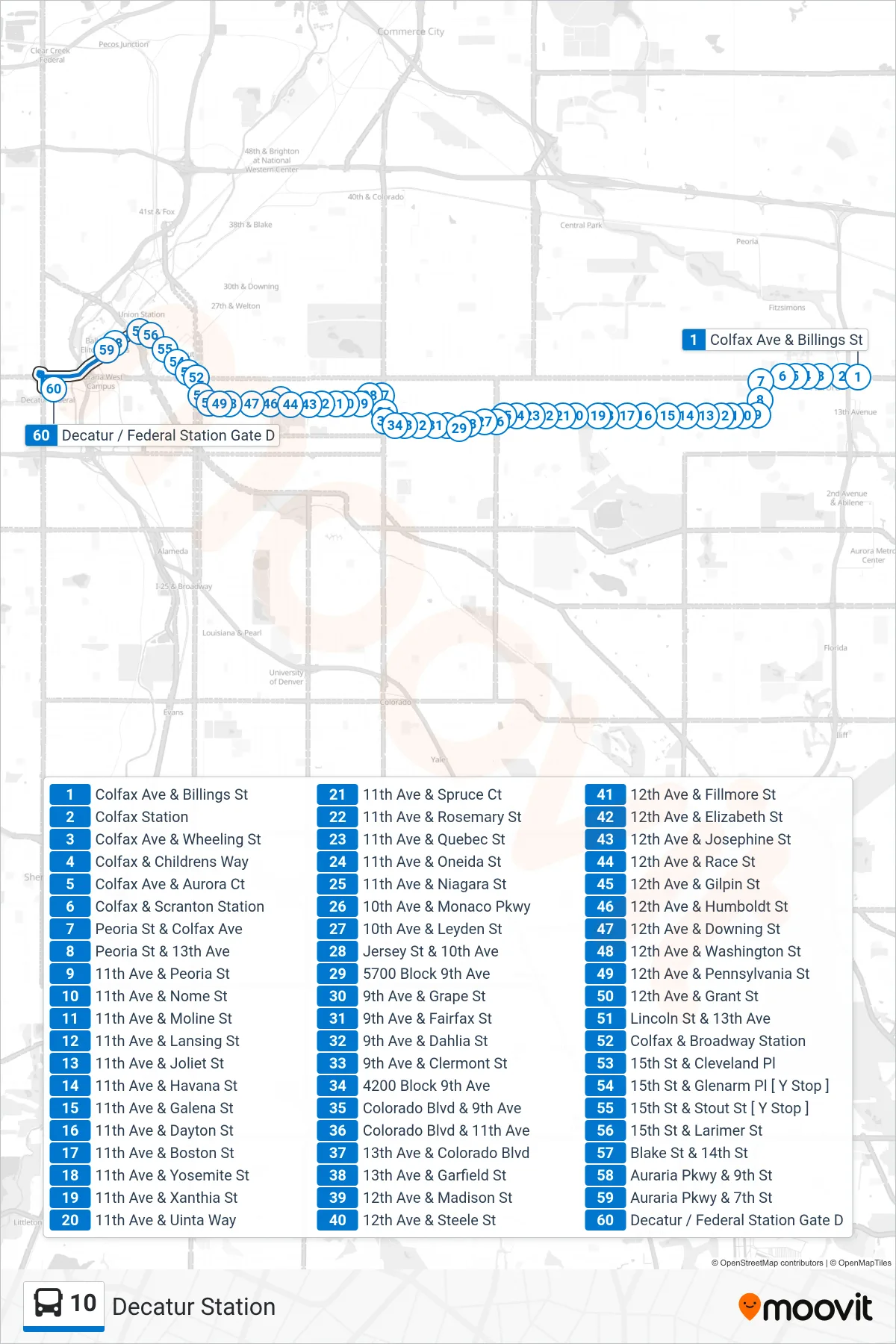
Stops list (10 - Decatur Station)
- Colfax Ave & Billings St
- Colfax Station
- Colfax Ave & Wheeling St
- Colfax & Childrens Way
- Colfax Ave & Aurora Ct
- Colfax & Scranton Station
- Peoria St & Colfax Ave
- Peoria St & 13th Ave
- 11th Ave & Peoria St
- 11th Ave & Nome St
- 11th Ave & Moline St
- 11th Ave & Lansing St
- 11th Ave & Joliet St
- 11th Ave & Havana St
- 11th Ave & Galena St
- 11th Ave & Dayton St
- 11th Ave & Boston St
- 11th Ave & Yosemite St
- 11th Ave & Xanthia St
- 11th Ave & Uinta Way
- 11th Ave & Spruce Ct
- 11th Ave & Rosemary St
- 11th Ave & Quebec St
- 11th Ave & Oneida St
- 11th Ave & Niagara St
- 10th Ave & Monaco Pkwy
- 10th Ave & Leyden St
- Jersey St & 10th Ave
- 5700 Block 9th Ave
- 9th Ave & Grape St
- 9th Ave & Fairfax St
- 9th Ave & Dahlia St
- 9th Ave & Clermont St
- 4200 Block 9th Ave
- Colorado Blvd & 9th Ave
- Colorado Blvd & 11th Ave
- 13th Ave & Colorado Blvd
- 13th Ave & Garfield St
- 12th Ave & Madison St
- 12th Ave & Steele St
- 12th Ave & Fillmore St
- 12th Ave & Elizabeth St
- 12th Ave & Josephine St
- 12th Ave & Race St
- 12th Ave & Gilpin St
- 12th Ave & Humboldt St
- 12th Ave & Downing St
- 12th Ave & Washington St
- 12th Ave & Pennsylvania St
- 12th Ave & Grant St
- Lincoln St & 13th Ave
- Colfax & Broadway Station
- 15th St & Cleveland Pl
- 15th St & Glenarm Pl [ Y Stop ]
- 15th St & Stout St [ Y Stop ]
- 15th St & Larimer St
- Blake St & 14th St
- Auraria Pkwy & 9th St
- Auraria Pkwy & 7th St
- Decatur / Federal Station Gate D