
11 Bus Route Map
View the 11 route map and see all 11 stops along the route. The map of 11 shows where the bus travels and the location of each stop, making it easy to understand the entire route at a glance.
Explore Aachener Straßenbahn- und Energieversorgungs-AG routes on the map and see where Aachener Straßenbahn- und Energieversorgungs-AG bus services operate. Use the 11 map to find bus stops and see how the 11 connects different areas along its trip.
All 11 stops on the map are displayed in route order, helping you follow the 11 bus from the first stop to the last.
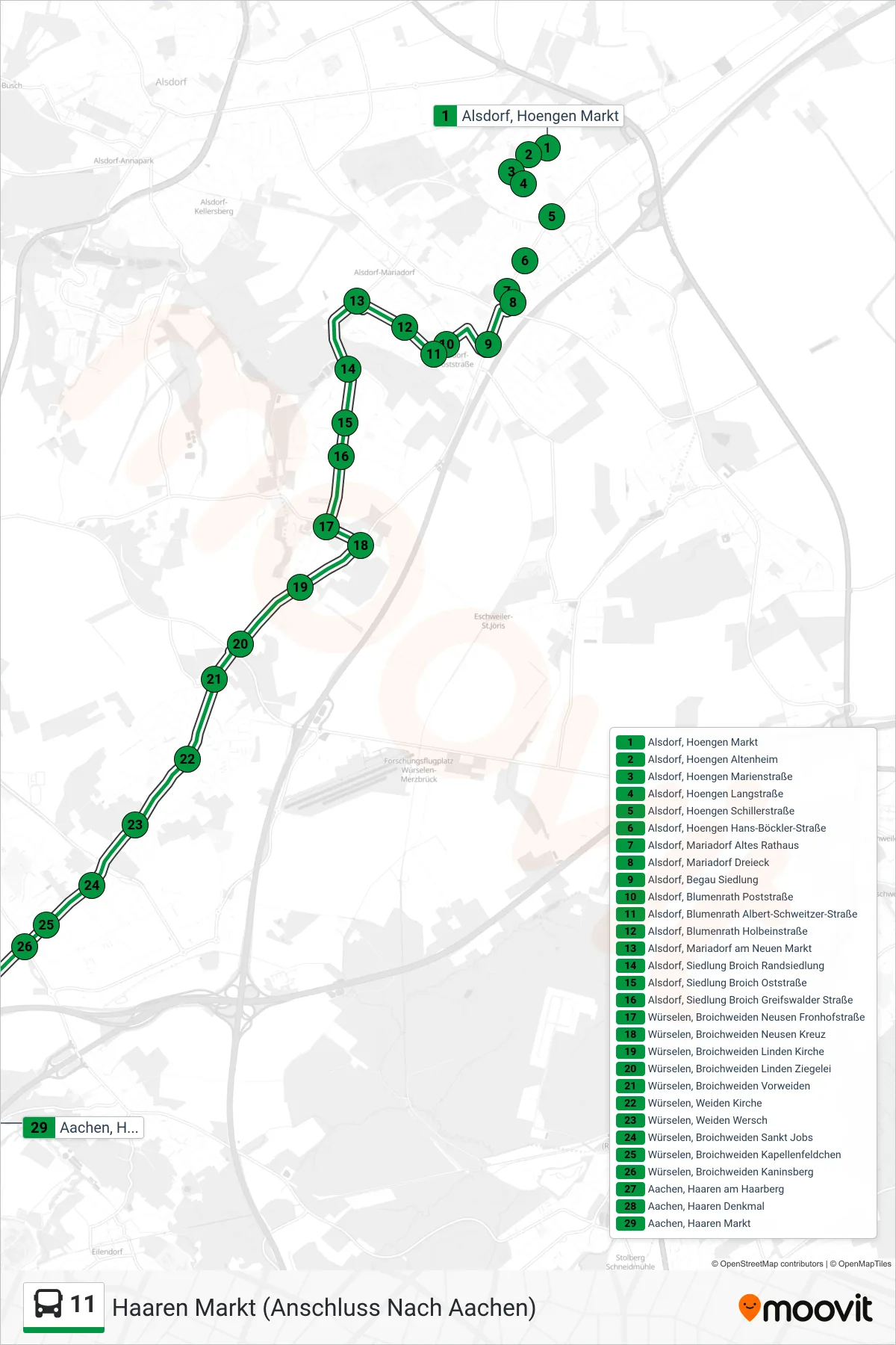
Stops list (11 - Haaren Markt (Anschluss Nach Aachen))
- Alsdorf, Hoengen Markt
- Alsdorf, Hoengen Altenheim
- Alsdorf, Hoengen Marienstraße
- Alsdorf, Hoengen Langstraße
- Alsdorf, Hoengen Schillerstraße
- Alsdorf, Hoengen Hans-Böckler-Straße
- Alsdorf, Mariadorf Altes Rathaus
- Alsdorf, Mariadorf Dreieck
- Alsdorf, Begau Siedlung
- Alsdorf, Blumenrath Poststraße
- Alsdorf, Blumenrath Albert-Schweitzer-Straße
- Alsdorf, Blumenrath Holbeinstraße
- Alsdorf, Mariadorf am Neuen Markt
- Alsdorf, Siedlung Broich Randsiedlung
- Alsdorf, Siedlung Broich Oststraße
- Alsdorf, Siedlung Broich Greifswalder Straße
- Würselen, Broichweiden Neusen Fronhofstraße
- Würselen, Broichweiden Neusen Kreuz
- Würselen, Broichweiden Linden Kirche
- Würselen, Broichweiden Linden Ziegelei
- Würselen, Broichweiden Vorweiden
- Würselen, Weiden Kirche
- Würselen, Weiden Wersch
- Würselen, Broichweiden Sankt Jobs
- Würselen, Broichweiden Kapellenfeldchen
- Würselen, Broichweiden Kaninsberg
- Aachen, Haaren am Haarberg
- Aachen, Haaren Denkmal
- Aachen, Haaren Markt
Change direction
- Route Map - 11 - Aachen, Siegel
- Route Map - 11 - Aachen Bushof (Weiter Als Li. 21)
- Route Map - 11 - Elisenbrunnen (Weiter Als Li. N8)
- Route Map - 11 - Aachen Bushof (Weiter Als Li. 51)
- Route Map - 11 - Aachen Hauptbahnhof
- Route Map - 11 - Schmithof Schule
- Route Map - 11 - Hoengen Markt
- Route Map - 11 - Mariadorf Dreieck
- Route Map - 11 - Mariadorf Montanstraße
- Route Map - 11 - Alsdorf, Hoengen Goethestraße
- Route Map - 11 - Schleckheim Kapelle
- Route Map - 11 - Alsdorf, Mariadorf Dreieck
- Route Map - 11 - Walheim Hasbach
- Route Map - 11 - Lichtenbusch
- Route Map - 11 - Schleckheim Schumag (Weiter Als Li. 55)
- Route Map - 11 - Aachen, Schmithof Kirche
- Route Map - 11 - Alsdorf, Hoengen Business Park Ost
- Route Map - 11 - Hoengen Business Park Süd
- Route Map - 11 - Siegel
- Route Map - 11 - Hoengen Business Park West
- Route Map - 11 - Lichtenbusch (Weiter Als Li. 55)
- Route Map - 11 - Sief Schule
- Route Map - 11 - Alsdorf, Hoengen Business Park Süd
- Route Map - 11 - Aachen Bushof
- Route Map - 11 - Alsdorf, Hoengen Business Park West
- Route Map - 11 - Hoengen Goethestraße
- Route Map - 11 - Hält Nur Zum Aussteigen
- Route Map - 11 - Aachen Waldfriedhof
- Route Map - 11 - Kaninsberg
- Route Map - 11 - Aachen, Walheim Hasbach
- Route Map - 11 - Mariadorf Dreieck