
111 Bus Route Map
View the 111 route map and see all 111 stops along the route. The map of 111 shows where the bus travels and the location of each stop, making it easy to understand the entire route at a glance.
Explore Cooperativa Nicarao routes on the map and see where Cooperativa Nicarao bus services operate. Use the 111 map to find bus stops and see how the 111 connects different areas along its trip.
All 111 stops on the map are displayed in route order, helping you follow the 111 bus from the first stop to the last.
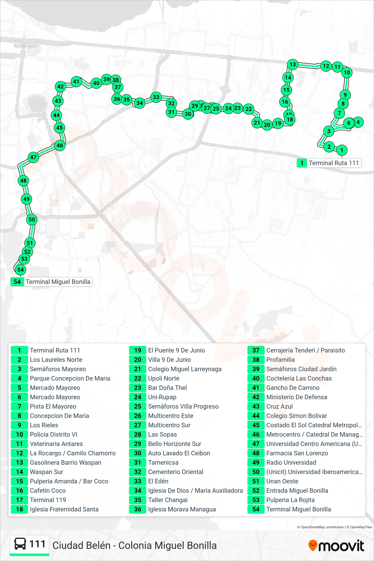
Stops list (111 - Colonia Miguel Bonilla)
- Terminal Ruta 111
- Los Laureles Norte
- Semáforos Mayoreo
- Parque Concepcion De Maria
- Mercado Mayoreo
- Mercado Mayoreo
- Pista El Mayoreo
- Concepcion De Maria
- Los Rieles
- Policía Distrito VI
- Veterinaria Antares
- La Rocargo / Camilo Chamorro
- Gasolinera Barrio Waspan
- Waspan Sur
- Pulperia Amanda / Bar Coco
- Cafetín Coco
- Terminal 119
- Iglesia Fraternidad Santa
- El Puente 9 De Junio
- Villa 9 De Junio
- Colegio Miguel Larreynaga
- Upoli Norte
- Bar Doña Thel
- Uni-Rupap
- Semáforos Villa Progreso
- Multicentro Este
- Multicentro Sur
- Las Sopas
- Bello Horizonte Sur
- Auto Lavado El Ceibon
- Tamenicsa
- Cementerio Oriental
- El Edén
- Iglesia De Dios / María Auxiliadora
- Taller Changai
- Iglesia Morava Managua
- Cerrajería Tenderí / Paraisito
- Profamilia
- Semáforos Ciudad Jardín
- Coctelería Las Conchas
- Gancho De Camino
- Ministerio De Defensa
- Cruz Azul
- Colegio Simon Bolivar
- Costado El Sol Catedral Metropolitana
- Metrocentro / Catedral De Managua
- Universidad Centro Americana (Uca)
- Farmacia San Lorenzo
- Radio Universidad
- (Unicit) Universidad Iberoamericana De Ciencia Y Tecnología
- Unan Oeste
- Entrada Miguel Bonilla
- Pulperia La Rojita
- Terminal Miguel Bonilla