
130 Bus Route Map
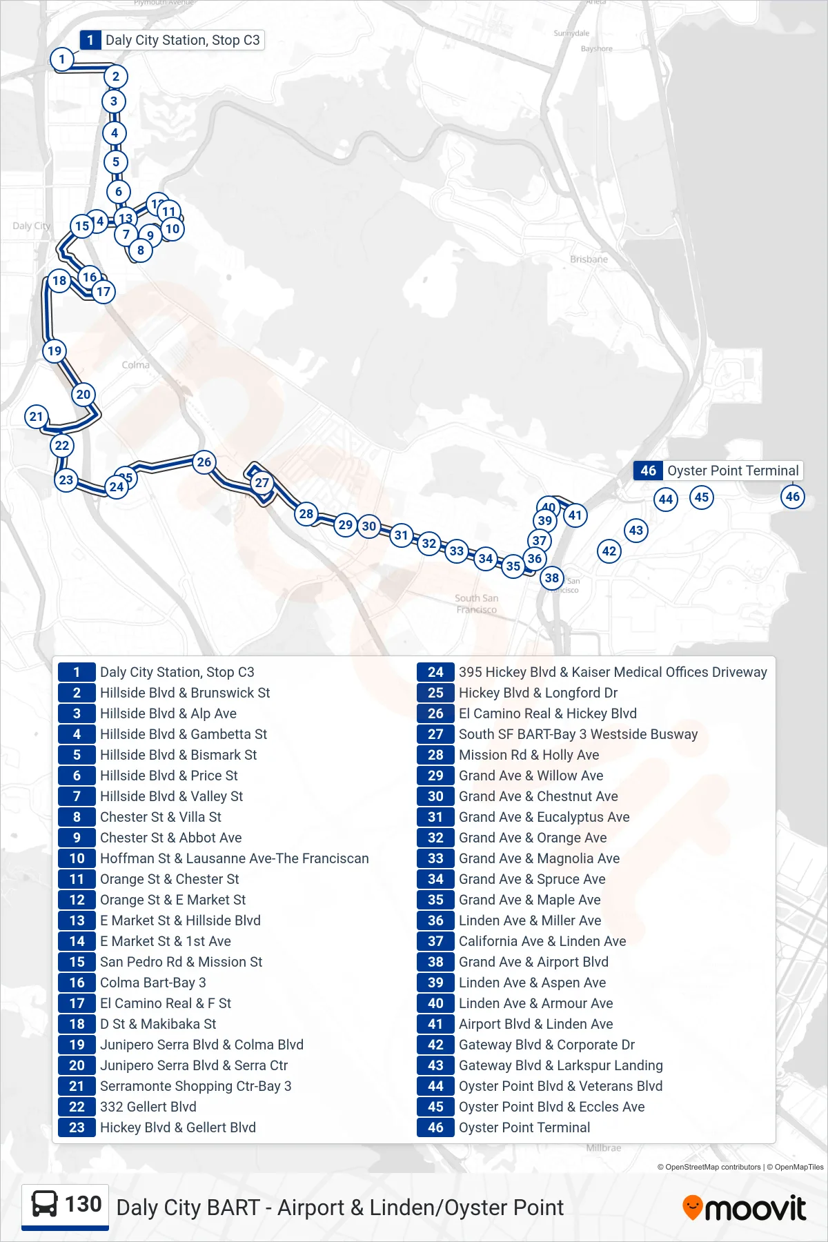
View the 130 route map and see all 130 stops along the route. The map of 130 shows where the bus travels and the location of each stop, making it easy to understand the entire route at a glance.
Explore SamTrans routes on the map and see where SamTrans bus services operate. Use the 130 map to find bus stops and see how the 130 connects different areas along its trip.
All 130 stops on the map are displayed in route order, helping you follow the 130 bus from the first stop to the last.
Stops list (130 - South San Francisco)
- Daly City Station, Stop C3
- Hillside Blvd & Brunswick St
- Hillside Blvd & Alp Ave
- Hillside Blvd & Gambetta St
- Hillside Blvd & Bismark St
- Hillside Blvd & Price St
- Hillside Blvd & Valley St
- Chester St & Villa St
- Chester St & Abbot Ave
- Hoffman St & Lausanne Ave-The Franciscan
- Orange St & Chester St
- Orange St & E Market St
- E Market St & Hillside Blvd
- E Market St & 1st Ave
- San Pedro Rd & Mission St
- Colma Bart-Bay 3
- El Camino Real & F St
- D St & Makibaka St
- Junipero Serra Blvd & Colma Blvd
- Junipero Serra Blvd & Serra Ctr
- Serramonte Shopping Ctr-Bay 3
- 332 Gellert Blvd
- Hickey Blvd & Gellert Blvd
- 395 Hickey Blvd & Kaiser Medical Offices Driveway
- Hickey Blvd & Longford Dr
- El Camino Real & Hickey Blvd
- South SF BART-Bay 3 Westside Busway
- Mission Rd & Holly Ave
- Grand Ave & Willow Ave
- Grand Ave & Chestnut Ave
- Grand Ave & Eucalyptus Ave
- Grand Ave & Orange Ave
- Grand Ave & Magnolia Ave
- Grand Ave & Spruce Ave
- Grand Ave & Maple Ave
- Linden Ave & Miller Ave
- California Ave & Linden Ave
- Grand Ave & Airport Blvd
- Linden Ave & Aspen Ave
- Linden Ave & Armour Ave
- Airport Blvd & Linden Ave
- Gateway Blvd & Corporate Dr
- Gateway Blvd & Larkspur Landing
- Oyster Point Blvd & Veterans Blvd
- Oyster Point Blvd & Eccles Ave
- Oyster Point Terminal