
14 Bus Route Map
View the 14 route map and see all 14 stops along the route. The map of 14 shows where the bus travels and the location of each stop, making it easy to understand the entire route at a glance.
Explore Nazareth Travel and Tourism routes on the map and see where Nazareth Travel and Tourism bus services operate. Use the 14 map to find bus stops and see how the 14 connects different areas along its trip.
All 14 stops on the map are displayed in route order, helping you follow the 14 bus from the first stop to the last.
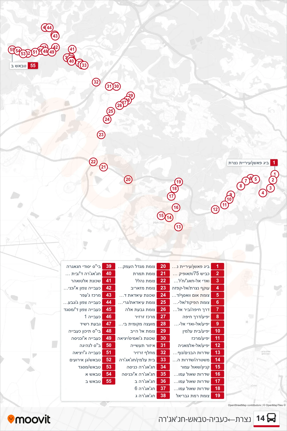
Stops list (14 - Nazareth→Kaabiya-Tabasch-Hajajre)
- Big Fashion/Nazareth Municipality
- Road 75/Tawfiq Ziad
- Wadi al-Haj/Khalet al-Dir
- Nazareth Bypass/Al-Qafza
- Um Wasaf Junction/Haifa Road
- Command Junction/Al-Amara
- Haifa Road/Bir Al-Amir
- Yafi'a/Haifa Road
- Yafi'a/Al-Wadi Al-Kharji
- Yafi'a/Cemetery
- Yafi'a/Center
- Yafi'a/Al-Almania
- HaBanim Boulevard/Nof HaEmek
- Police/HaBanim Boulevard
- Mall/Shaul Amor
- Shaul Amor Boulevard/Nahal HaTzvi
- Shaul Amor Blvd/HaTa'asiya
- Shaul Amor Boulevard/HaLavyan
- Ramat Gabriel Junction
- Migdal HaEmek Junction 75/7555
- Timrat Junction
- Nahalal Junction
- Mazarib Junction
- Southern Ayadat Neighborhood
- Ayadat/Grifat Junction
- Givat Ela Junction
- Zarzir Center
- Beit Zarzir Local Council
- Al Hib Junction
- Jawamis Neighborhood/Exit
- Industrial Zone
- Zarzir Interchange
- Cemetery/Hajajra
- Hajajra Entrance
- Hajajra A/Entrance
- Hajajra B
- Hajajra 6
- Hajajra C
- Hajajra Elementary School
- Hajajra D/Elementary School
- Al-Twahar Neighborhood
- Kaabiya North A/Entrance
- Jaffer Center
- Kaabiya North C/Rashid Hill
- Kaabiya North D/Mosque
- Kaabiya 1
- Givat Rashid
- Kaabiya High School
- Kaabiya A/Entrance
- Driving School
- Kaabiya G/Exit
- Tabash/Event Garden
- Tabash/Mosque
- Tabash A
- Tabash B