
140 Bus Route Map
View the 140 route map and see all 140 stops along the route. The map of 140 shows where the bus travels and the location of each stop, making it easy to understand the entire route at a glance.
Explore KVB Kölner Verkehrs-Betriebe AG routes on the map and see where KVB Kölner Verkehrs-Betriebe AG bus services operate. Use the 140 map to find bus stops and see how the 140 connects different areas along its trip.
All 140 stops on the map are displayed in route order, helping you follow the 140 bus from the first stop to the last.
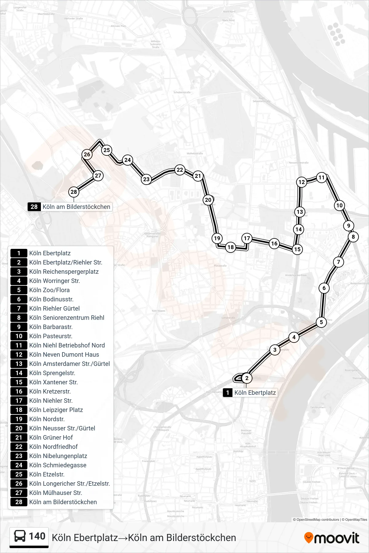
Stops list (140 - Köln Ebertplatz→Köln am Bilderstöckchen)
- Köln Ebertplatz
- Köln Ebertplatz/Riehler Str.
- Köln Reichenspergerplatz
- Köln Worringer Str.
- Köln Zoo/Flora
- Köln Bodinusstr.
- Köln Riehler Gürtel
- Köln Seniorenzentrum Riehl
- Köln Barbarastr.
- Köln Pasteurstr.
- Köln Niehl Betriebshof Nord
- Köln Neven Dumont Haus
- Köln Amsterdamer Str./Gürtel
- Köln Sprengelstr.
- Köln Xantener Str.
- Köln Kretzerstr.
- Köln Niehler Str.
- Köln Leipziger Platz
- Köln Nordstr.
- Köln Neusser Str./Gürtel
- Köln Grüner Hof
- Köln Nordfriedhof
- Köln Nibelungenplatz
- Köln Schmiedegasse
- Köln Etzelstr.
- Köln Longericher Str./Etzelstr.
- Köln Mülhauser Str.
- Köln am Bilderstöckchen
Change direction
- Route Map - 140 - Köln Rochusplatz→Köln Ebertplatz
- Route Map - 140 - Köln Ebertplatz→Köln Niehl Betriebshof Nord
- Route Map - 140 - Köln Ebertplatz→Köln Neusser Str./Gürtel
- Route Map - 140 - Köln am Bilderstöckchen→Köln Leipziger Platz
- Route Map - 140 - Köln Geldernstr./Parkgürtel→Köln Wasseramselweg
- Route Map - 140 - Köln Neusser Str./Gürtel→Köln Ebertplatz
- Route Map - 140 - Köln am Bilderstöckchen→Köln Neusser Str./Gürtel
- Route Map - 140 - Köln Neusser Str./Gürtel→Köln am Bilderstöckchen
- Route Map - 140 - Köln am Bilderstöckchen→Köln Ebertplatz
- Route Map - 140 - Köln Ebertplatz→Köln Rochusplatz
- Route Map - 140 - Köln Aachener Str./Gürtel→Köln Ebertplatz
- Route Map - 140 - Köln Niehl Betriebshof Nord→Köln Ebertplatz
- Route Map - 140 - Köln Etzelstr.→Köln Ebertplatz
- Route Map - 140 - Köln Ebertplatz→Köln Aachener Str./Gürtel