
152 Bus Route Map
View the 152 route map and see all 152 stops along the route. The map of 152 shows where the bus travels and the location of each stop, making it easy to understand the entire route at a glance.
Explore KVB Kölner Verkehrs-Betriebe AG routes on the map and see where KVB Kölner Verkehrs-Betriebe AG bus services operate. Use the 152 map to find bus stops and see how the 152 connects different areas along its trip.
All 152 stops on the map are displayed in route order, helping you follow the 152 bus from the first stop to the last.
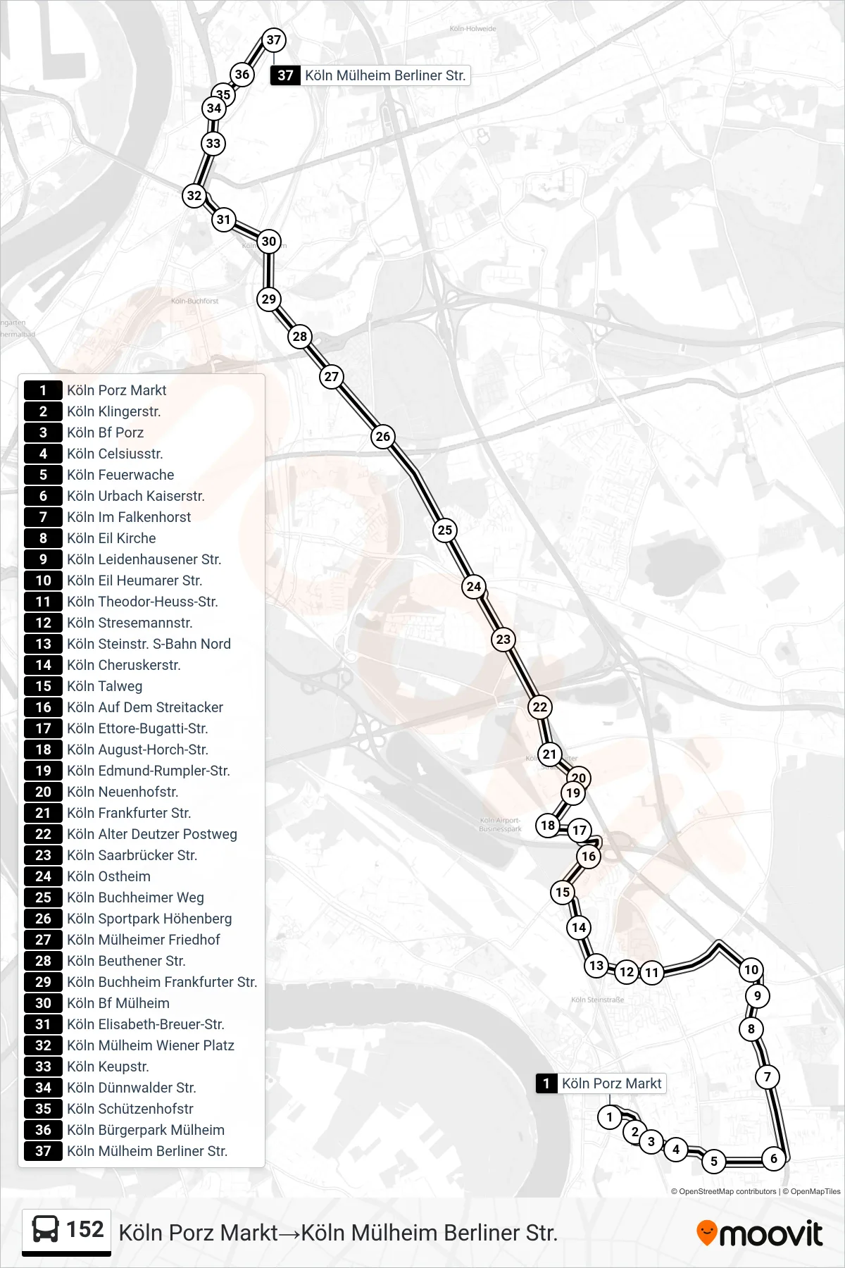
Stops list (152 - Köln Porz Markt→Köln Mülheim Berliner Str.)
- Köln Porz Markt
- Köln Klingerstr.
- Köln Bf Porz
- Köln Celsiusstr.
- Köln Feuerwache
- Köln Urbach Kaiserstr.
- Köln Im Falkenhorst
- Köln Eil Kirche
- Köln Leidenhausener Str.
- Köln Eil Heumarer Str.
- Köln Theodor-Heuss-Str.
- Köln Stresemannstr.
- Köln Steinstr. S-Bahn Nord
- Köln Cheruskerstr.
- Köln Talweg
- Köln Auf Dem Streitacker
- Köln Ettore-Bugatti-Str.
- Köln August-Horch-Str.
- Köln Edmund-Rumpler-Str.
- Köln Neuenhofstr.
- Köln Frankfurter Str.
- Köln Alter Deutzer Postweg
- Köln Saarbrücker Str.
- Köln Ostheim
- Köln Buchheimer Weg
- Köln Sportpark Höhenberg
- Köln Mülheimer Friedhof
- Köln Beuthener Str.
- Köln Buchheim Frankfurter Str.
- Köln Bf Mülheim
- Köln Elisabeth-Breuer-Str.
- Köln Mülheim Wiener Platz
- Köln Keupstr.
- Köln Dünnwalder Str.
- Köln Schützenhofstr
- Köln Bürgerpark Mülheim
- Köln Mülheim Berliner Str.
Change direction
- Route Map - 152 - Köln Porz Markt→Leverkusen Chempark S-Bahn
- Route Map - 152 - Köln Porz Markt→Köln Mülheim Wiener Platz
- Route Map - 152 - Köln Mülheim Wiener Platz→Köln Porz Markt
- Route Map - 152 - Leverkusen Chempark S-Bahn→Köln Porz Markt
- Route Map - 152 - Leverkusen Chempark S-Bahn→Köln Mülheim Wiener Platz
- Route Map - 152 - Köln Hermann-Ost-Str.→Köln Ostheim
- Route Map - 152 - Köln Mülheim Wiener Platz→Leverkusen Chempark S-Bahn