
157 Bus Route Map
View the 157 route map and see all 157 stops along the route. The map of 157 shows where the bus travels and the location of each stop, making it easy to understand the entire route at a glance.
Explore KVB Kölner Verkehrs-Betriebe AG routes on the map and see where KVB Kölner Verkehrs-Betriebe AG bus services operate. Use the 157 map to find bus stops and see how the 157 connects different areas along its trip.
All 157 stops on the map are displayed in route order, helping you follow the 157 bus from the first stop to the last.
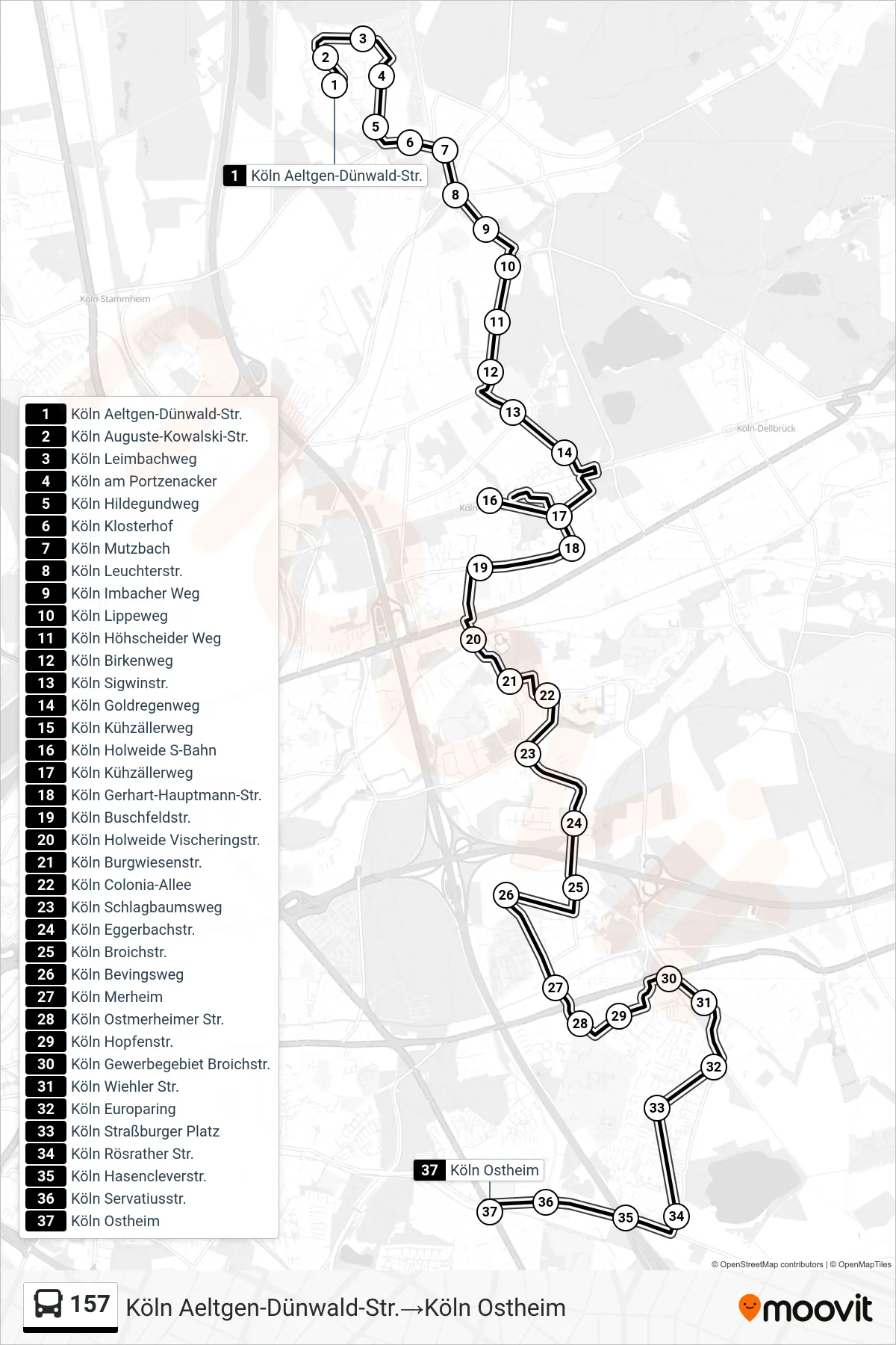
Stops list (157 - Köln Aeltgen-Dünwald-Str.→Köln Ostheim)
- Köln Aeltgen-Dünwald-Str.
- Köln Auguste-Kowalski-Str.
- Köln Leimbachweg
- Köln am Portzenacker
- Köln Hildegundweg
- Köln Klosterhof
- Köln Mutzbach
- Köln Leuchterstr.
- Köln Imbacher Weg
- Köln Lippeweg
- Köln Höhscheider Weg
- Köln Birkenweg
- Köln Sigwinstr.
- Köln Goldregenweg
- Köln Kühzällerweg
- Köln Holweide S-Bahn
- Köln Kühzällerweg
- Köln Gerhart-Hauptmann-Str.
- Köln Buschfeldstr.
- Köln Holweide Vischeringstr.
- Köln Burgwiesenstr.
- Köln Colonia-Allee
- Köln Schlagbaumsweg
- Köln Eggerbachstr.
- Köln Broichstr.
- Köln Bevingsweg
- Köln Merheim
- Köln Ostmerheimer Str.
- Köln Hopfenstr.
- Köln Gewerbegebiet Broichstr.
- Köln Wiehler Str.
- Köln Europaring
- Köln Straßburger Platz
- Köln Rösrather Str.
- Köln Hasencleverstr.
- Köln Servatiusstr.
- Köln Ostheim
Change direction
- Route Map - 157 - Köln Ostheim→Köln Sigwinstr.
- Route Map - 157 - Köln Ostheim→Köln Eggerbachstr.
- Route Map - 157 - Köln Eggerbachstr.→Köln Ostheim
- Route Map - 157 - Köln Holweide S-Bahn→Köln Ostheim
- Route Map - 157 - Köln Ostheim→Köln Aeltgen-Dünwald-Str.
- Route Map - 157 - Köln Ostheim→Köln Holweide S-Bahn
- Route Map - 157 - Köln Sigwinstr.→Köln Ostheim
- Route Map - 157 - Köln Ostheim→Köln Merheim